 Catalogue PIGMA
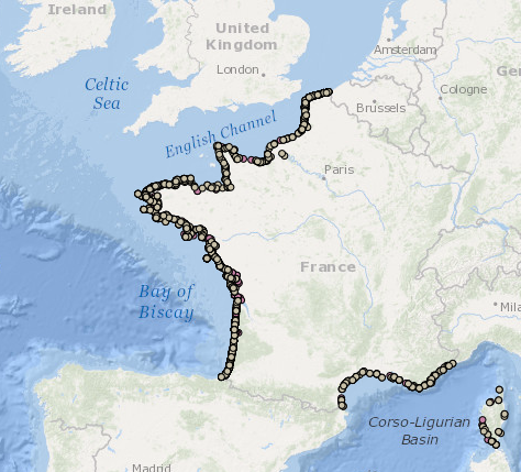
Bilans des échouages de mammifères marins sur le littoral de France métropolitaine en 2014-2020
Marine mammal strandings along French coasts in 2014-2020
Données d’occurrence des échouages de mammifères marins collectées par les correspondants du Réseau National Echouages (date, position, espèce) en métropole en 2014-2020.
cd_nom: code de l'espèce observée selon taxref
lb_nom: nom latin de l'espèce observée selon taxref
nom_commun: nom commun de l'espèce observée selon taxref
date_obs: jj/mm/aaaa, date de l'observation de l'animal échoué
com_codes_insee: code de la commune de l'échouage selon l'INSEE
com_nom: nom de la commune selon l'INSEE
com_coord_lat: y en degrés décimaux de la commune de l'échouage
com_coord_long: x en degrés décimaux de la commune de l'échouage
id_mammifere: référence de l'animal dans la base de données Pelagis
identiteObservateur: nom du correspondant ayant effectué l'observation
organismeObservateur: organisme du correspondant ayant effectué l'observation
organismeGestionnaireDonnees: organisme assurant la gestion de la base de données
Simple
-
Autres appellations ou acronymes
-
Convention AAMP/15/054 RNE_échouages_AAMP_pt_wgs84
-
Date (Publication)Date (Publication)
- 2016-01-19
-
IdentifierIdentificateur
- Convention AAMP/15/054 RNE_échouages_AAMP_pt_wgs84
05 46 44 99 45
www.observatoire-pelagis.cnrs.fr
-
Presentation formForme de la présentation
-
Digital mapCarte numérique
-
ButPurpose
-
Produire un état des lieux de la distribution spatiale et de l'abondance de ces espèces et d’en évaluer la variabilité spatiale et temporelle afin d'alimenter une réflexion commune pour la désignation et gestion d’aires marines protégées.To produce an inventory of the spatial distribution and abundance of these species and to evaluate their spatial and temporal variability in order to provide the information required to designate and manage marine protected areas.
-
ReconnaissanceCredit
-
Réseau National Echouages, Observatoire PELAGIS - UMS 3462 ULR/CNRS, Agence des Aires Marines ProtégéesPELAGIS observatory- UMS 3462 ULR/CNRS, marine protection agency
-
StatusEtat
-
Under developmentEn cours de création
-
Maintenance and update frequencyFréquence de mise à jour
-
As neededLorsque nécessaire
-
Nom
-
ESRI Shapefile
- Version
- 0.1
-
ThemeThème
-
-
échouage
-
cétacé
-
mammifère marin
-
pinnipèdeMarine bird
-
occurrence
-
présencePresence
-
distribution
-
-
PlaceLocalisation
-
-
France
-
métropoleMainland
-
MancheEnglish Channel
-
AtlantiqueAtlantic
-
golfe de GascogneBay of Biscay
-
Méditerranée
-
-
GEMET - INSPIRE themes, version 1.0
-
-
Répartition des espècesSpecies distribution
-
-
Thèmes Sextant
-
-
/Milieu biologique/Espèces/Faune/Biological Environment/Species/Fauna
-
-
Sous-regions marines
-
-
/Métropole/Metropolitan France
-
/Métropole/Manche mer du Nord/Metropolitan France/Channel-North Sea
-
/Métropole/Méditerranée occidentale/Metropolitan France/Western Mediterranean
-
/Métropole/Mers Celtiques/Metropolitan France/Celtic Seas
-
/Métropole/Golfe de Gascogne/Metropolitan France/Bay of Biscay
-
-
DCSMM : Descripteurs
-
-
D1: Biodiversité - Mammifères
-
-
Cadre Réglementaire - SIMM
-
-
Directive Cadre pour la Planification de l'Espace Maritime (DCPEM)Maritime Spatial Planning Directive (MSP)
-
Directive Cadre Stratégie pour le Milieu Marin (DCSMM)Marine Strategy Framework Directive (MSFD)
-
-
Thématiques - SIMM
-
-
/Etat du Milieu/Espèces/Environmental Status/Species
-
-
Ocean Hackathon - Ville et défi
-
-
/Cherbourg/Cherbourg
-
/Brest/Brest
-
/Boulogne-sur-Mer/Boulogne-sur-Mer
-
/Toulon/Toulon
-
/La Rochelle/La Rochelle
-
-
UtilisationSpecific usage
-
Occurence
Distribution
Abondance relative
Presence at sea Distribution at sea
Combining Observation and observation effort :
To define the abundance and distribution of Marine Mammals
Geostatistical modelling
Modelling of preferred habitats
Natura 2000 en mer
Marine Strategy Framework Directive
- User determined limitations
- Les échouages sont le résultat de variations dans l'abondance et la mortalité des mammifères marins en mer, mais aussi des conditions météorologiques et courantologiques qui peuvent mener à l'échouage et sa découverte. Ils doivent donc être interprétés à la lumière de ces fluctuations.
05 46 44 99 45
05 46 44 99 45
-
Limitation d'utilisationUse limitation
-
Utilisation à usage non commercial et sous réserve de mentionner la source (a minima le nom du producteur) et la date de sa dernière mise à jour. Les données d'occurrences témoignent de la présence des espèces (et non pas de leur distribution vraie) et non de leur absence car l'observation des échouages sur le littoral est la conséquence de nombreux paramètres physiques, climatiques et biologiques qui ne sont pas pris en compte dans le jeu de données. Toute interprétation sans analyse préalable et au delà des limites citées est donc sujette à caution. L’utilisation de l'ensemble du jeu de données devra faire l’objet d’une demande à l’Observatoire Pelagis et passe par le respect d'une charte d'utilisation des données produites par l'Observatoire. Il n'y a pas de données 'brutes' dans la mesure où la présente donnée a été validée, corrigée d’un point de vue technique et scientifique.Non commercial use only on the condition that the source is cited in all publications (citing at least the name of the producer) along with the date of the latest update. Occurrence data attests to the presence of species (not their true distribution), rather than their absence as they are not corrected for observation effort. All interpretation without prior analysis and beyond the limitations mentioned should be treated with caution. Use of the dataset as a whole (observation parameters and associated efforts) will be the subject of a request made to the PELAGIS observatory and must respect the Observatory’s data usage charter. Attention! The observations only have quantitative value when they are associated with an observation effort exerted on a specific transect (number of observations/observation time). There is no "raw" data insomuch as the present data has been validated and corrected from a technical and scientific perspective.
-
Access constraintsContraintes d'accès
-
Intellectual property rightsDroit de propriété intellectuelle / Droit patrimonial
-
Use constraintsContraintes d'utilisation
-
Other restrictionsAutres restrictions
-
Autres contraintesOther constraints
-
Obligation de citation "Réseau National Echouages, Observatoire PELAGIS, UMS 3462 ULR/CNRS, AAMP,Occurence des donnéesd'échouages de mammifères marins'"
Obligation de prise de contact pour tout usage, toute publication scientifique et/ou "coauthorship" si jugé nécessaire par les propriétaires
Mandatory citation "Observatoire PELAGIS, UMS 3462 ULR/
CNRS, AAMP, CEBC, 'database name'"
Users must make contact with the data providers prior to all use, scientific publication and/or "coauthorship" if considered necessary by the owners of the data.
-
Spatial representation typeType de représentation spatiale
-
VectorVecteur
-
DenominatorDénominateur de l'échelle
- 1000000
-
DistanceDistance de résolution
- 100 mètre
-
Metadata languageLangue
- Français
-
Character setJeu de caractères
-
UTF8Utf8
-
Topic categoryCatégorie ISO
-
-
BiotaBiote
-
-
Description de l'environnement de travail
-
FME 2013+, Arcgis 10+, Access 2003, VOR, Windows 7
))
- Begin date
- 2014-01-01T00:00:00
- End date
- 2020-12-31T00:00:00
-
Informations supplémentairesSupplemental Information
-
- Métadonnée en cours de rédaction -Metadata being drafted
-
Reference system identifierNom du système de référence
-
EPSG
/
RGF93 (EPSG:4171)/ 8.6
-
Topology levelNiveau topologie
-
Geometry onlyGéométrie seulement
-
OnLine resourceRessource en ligne
-
PELAGIS_ECHOUAGE_MAMMIFERES_MARINS_METRO_2014 PELAGIS_ECHOUAGE_MAMMIFERES_MARINS_METRO_2014
(
OGC:WMS
)
Échouages de mammifères marins en 2014 - France métropolitaineMarine mammal strandings in 2014 - French metropolitan coast
- Protocol
- FILE
-
NomName
-
PELAGIS_ECHOUAGE_MAMMIFERES_MARINS_METRO_2014PELAGIS_ECHOUAGE_MAMMIFERES_MARINS_METRO_2014
-
DescriptionDescription
-
Échouages de mammifères marins en 2014 - France métropolitaineMarine mammal strandings in 2014 - French metropolitan coast
-
OnLine resourceRessource en ligne
-
PELAGIS_ECHOUAGE_MAMMIFERES_MARINS_METRO_2015 PELAGIS_ECHOUAGE_MAMMIFERES_MARINS_METRO_2015
(
OGC:WMS
)
Échouages de mammifères marins en 2015 - France métropolitaineMarine mammal strandings in 2015 - French metropolitan coast
- Protocol
- FILE
-
NomName
-
PELAGIS_ECHOUAGE_MAMMIFERES_MARINS_METRO_2015PELAGIS_ECHOUAGE_MAMMIFERES_MARINS_METRO_2015
-
DescriptionDescription
-
Échouages de mammifères marins en 2015 - France métropolitaineMarine mammal strandings in 2015 - French metropolitan coast
-
OnLine resourceRessource en ligne
-
PELAGIS_ECHOUAGE_MAMMIFERES_MARINS_METRO_2016
(
OGC:WMS
)
Échouages de mammifères marins en 2016 - France métropolitaine
- Protocol
- FILE
-
Nom
-
PELAGIS_ECHOUAGE_MAMMIFERES_MARINS_METRO_2016
-
Description
-
Échouages de mammifères marins en 2016 - France métropolitaine
-
OnLine resourceRessource en ligne
-
PELAGIS_ECHOUAGE_MAMMIFERES_MARINS_METRO_2017
(
OGC:WMS
)
Échouages de mammifères marins en 2017 - France métropolitaine
- Protocol
- FILE
-
Nom
-
PELAGIS_ECHOUAGE_MAMMIFERES_MARINS_METRO_2017
-
Description
-
Échouages de mammifères marins en 2017 - France métropolitaine
-
OnLine resourceRessource en ligne
-
PELAGIS_ECHOUAGE_MAMMIFERES_MARINS_METRO_2018
(
OGC:WMS
)
Échouages de mammifères marins en 2018 - France métropolitaine
- Protocol
- FILE
-
Nom
-
PELAGIS_ECHOUAGE_MAMMIFERES_MARINS_METRO_2018
-
Description
-
Échouages de mammifères marins en 2018 - France métropolitaine
-
OnLine resourceRessource en ligne
-
PELAGIS_ECHOUAGE_MAMMIFERES_MARINS_METRO_2019
(
OGC:WMS
)
Échouages de mammifères marins en 2019 - France métropolitaine
- Protocol
- FILE
-
Nom
-
PELAGIS_ECHOUAGE_MAMMIFERES_MARINS_METRO_2019
-
Description
-
Échouages de mammifères marins en 2019 - France métropolitaine
-
OnLine resourceRessource en ligne
-
PELAGIS_ECHOUAGE_MAMMIFERES_MARINS_METRO_2020
(
OGC:WMS
)
Échouages de mammifères marins en 2020 - France métropolitaine
- Protocol
- FILE
-
Nom
-
PELAGIS_ECHOUAGE_MAMMIFERES_MARINS_METRO_2020
-
Description
-
Échouages de mammifères marins en 2020 - France métropolitaine
-
OnLine resourceRessource en ligne
- Digital Object Identifier (DOI) ( DOI )
-
Hierarchy levelNiveau
-
DatasetJeu de données
-
Généralités sur la provenanceStatement
-
Ce jeu de données est issu de la base appelée BDD Echouages (base de données
développée et administrée par l'UMS 3468 BBEES) et il rassemble les données
d'échouages de mammifères marins issues du RNE. Ce programme national
correspond à la plus longue série historique sur ces espèces en France. Il permet de
suivre de nombreux paramètres en plus de la diversité et de la distribution, comme
des paramètres démographiques, écologiques, et sanitaires.
- Data taken from the following collection and validation protocol : Methodological guide to observing marine mammals and birds in the France’s mainland coastal waters and adjacent areas – PACOMM – SAMM Programme . G.Dorémus et al. 2011.
- The acquisition protocol for this data on these campaigns was implemented thanks to the experience of the team from the PELAGIS observatory gathered over more than 10 years in the field, and notable through the aerial observation campaigns ROMER( 2000-2002), ATLANCET (2003) and SCANS (2005)
Observations are made from an aeroplane flying over predefined transects at a constant altitude of 600 feet and a speed of 90 knots. Two observers record the environmental conditions and the following observations (at the surface or below the surface):
- Using the strip transect method (200m strips): bird observations
- Using the line transect methods (up to 500m): observations of marine mammals, sharks, rays, bony fish (large fish or shoals of fish) and sea turtles.
- Using the strip transect method: macro waste (200 m strips) and boats (500m strips)
Data is collected and coordinated by the PELAGIS observatory by scientific teams and observers, all of whom are specifically trained in aerial observation protocol (identical protocols for REMMOA and SAMM).
Result: SAMM campaigns have made it possible to collect over 20,000 pieces of data of the same type in France’s mainland waters along over 100,000 km of transects.
REMMOA campaigns have made it possible to collect over 55,000 observations of marine megafauna and human activity (waste, vessels and fishing gear) over nearly 205,000 km of transects covered by plane over the sea.
- flyovers in mainland France – SAMM campaign (Aerial Marine Megafauna Monitoring) – are conducted in the context of the PACOMM programme in order to meet community objectives for conservation and the promotion of maritime areas (Natura 2000, MSFD, regional maritime conventions, etc.).
The dataset is made up of two datasets: samm1 for winter 2011 and samm2 for summer 2012.
-
DescriptionDescription
-
-Les données sont collectées par un ensemble de plus de 400 correspondants, bénévoles ou salariés de structures associatives ou gouvernementales sur l'environnement. Ils sont formés par l'observatoire Pelagis, et appliquent un protocole standardisé décrit dansVan Canneyt et al.2015 Le guide des échouages de mammifères marins. Cahier technique de l'Observatoire PELAGIS sur le suivi de la mégafaune marine. Université de La Rochelle et CNRS, 64 pp. (disponible à l'adresse suivante : http://www.observatoire-pelagis.cnrs.fr/publications/ouvrage/article/le-guide-des-echouages-de ).
At least one campaign is attributed to each region of study.
Observers are attributed a campaign and a geographical area. For each sector there are bathymetric strata and transects which are linked to each of these strata (with a few exceptions for the Indian Ocean).
- Definition of sectors: zones corresponding to distinct maritime areas (seaboard, coast, archipelago, etc.)
- Definition of bathymetric strata : areas at the heart of each sector, determined according to bathymetric characteristics such as depth, relief and slope gradient.
- Definition of transects : breakdown of the observation effort between the bathymetric strata was defined according to expected observation rate (available in the literature or from previous unpublished campaigns) in order to obtain a significant number of observations for cetaceans and to make it possible to modify the effort during the campaign according to the real observation rate (increase or decrease of effort. The transects are distributed systematically within the strata.
-
But du processusRationale
-
ACQUISITIONSAMPLING PROGRAMME
-
DescriptionDescription
-
Les données sont ensuite validées et saisies dans une base de données Xataface administrée par l'Observatoire Pelagis et l'UMS BBEES.
Data was acquired during the flights and is also recorded digitally.
Back on land, the data is checked and errors removed. Corresponding codes for species, name, family and genus were verified using the TAXREFv5.0 reference. If need be, species identification is refined using photos taken during the flyovers. Data remains in the initial system of coordinates. Data is acquired within the context of a protocol defined as of acquisition (observers trained) for technical and scientific validation overseen by the PELAGIS observatory.
-
But du processus
-
VALIDATION / SAISIE
-
Included with datasetInclus dans le jeu de données
- No
-
Feature catalogue citationRéférence du catalogue d'objet
-
File identifierIdentifiant de la fiche
- 1925f710-315c-48c2-8ca7-5f0718d872f6 XML
-
Metadata languageLangue
- Français
-
Character setJeu de caractères
-
UTF8Utf8
- Parent identifier
- 9efd49a8-e85c-4393-988d-035a86b58977 9efd49a8-e85c-4393-988d-035a86b58977
-
Hierarchy levelType de ressource
-
SeriesCollection de données
-
Date stampDate des métadonnées
- 2023-11-16T13:45:31.8Z
- Metadata standard name
- ISO 19115:2003/19139 - SEXTANT
- Metadata standard version
- 1.0
05 46 44 99 45
Overviews
Spatial extent
Provided by
