 Catalogue PIGMA
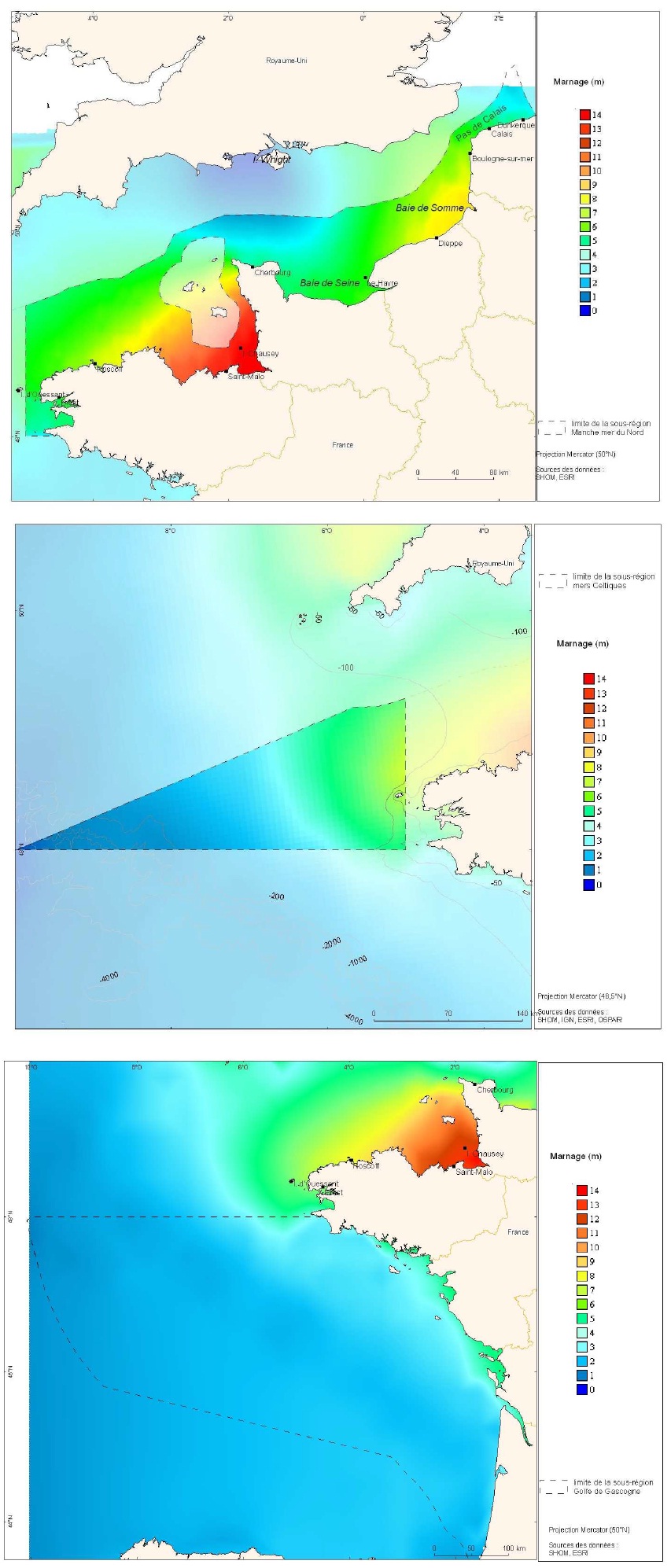
Courantologie : marnages
Cartes des marnages issues de la modélisation de marée CSTFRANCE pour les trois sous-régions marines Manche-mer du Nord, mers Celtiques et golfe de Gascogne.
Simple
- Date (Publication)
- 2013-08-21T10:30:00
- Identifier
- FR-marnages
- Presentation form
- Digital map
- Credit
- SHOM, Ifremer
- Status
- On going
- Maintenance and update frequency
- As needed
- Thèmes Sextant
-
- /Physical Environment/Hydrodynamics/Tide
- Theme
-
- circulation océanique
- courantologie
- état écologique
- marnage
- Place
-
- Manche - mer du Nord
- Golfe de Gascogne
- Mers Celtiques
- GEMET - INSPIRE themes, version 1.0
-
- Oceanographic geographical features
- Sous-regions marines
-
- Bay of Biscay
- Channel-North Sea
- Celtic Seas
- Use limitation
- Accès restreint
- Access constraints
- Intellectual property rights
- Use constraints
- Restricted
- Spatial representation type
- Grid
- Denominator
- 100000
- Metadata language
- Français
- Character set
- UTF8
- Topic category
-
- Oceans
N
S
E
W
))
- Reference system identifier
- 4326
- Topology level
- Geometry only
- Geometric object type
- Complex
Distributor
Distributor
Ifremer - Centre de Brest
-
Sextant server administrator
(
Appointed custodian for digital data
)
- Name
- fichier Shape ESRI
- Version
- ArcGIS 9.3.1
- OnLine resource
- Site web DCSMM ( WWW:LINK )
- Hierarchy level
- Dataset
- Statement
- Les images ont été générées à partir de données issues de modélisation de marée CSTFRANCE. Ces produits sont distribués par le SHOM.
- File identifier
- 5c49cee2-9e9c-4eb3-bd11-a66b90fd91a4 XML
- Metadata language
- Français
- Character set
- UTF8
- Hierarchy level
- Dataset
- Date stamp
- 2020-06-04T00:24:14
- Metadata standard name
- ISO 19115:2003/19139 - SEXTANT
- Metadata standard version
- 1.0
Overviews
Spatial extent
N
S
E
W
Provided by

Associated resources
Not available