 Catalogue PIGMA
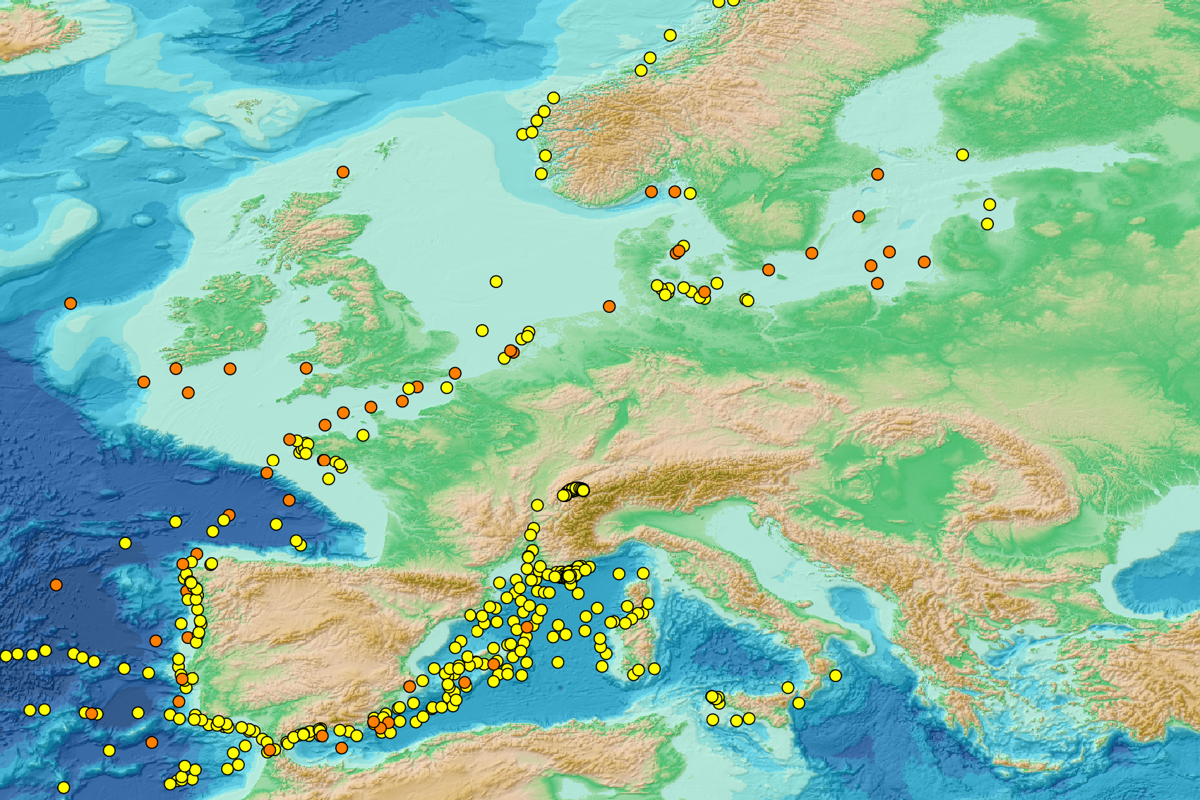
Micro litter - Nets location & mesh size used - Other specific protocols 2011/2021 v2025
This visualization product displays nets locations (start positions) where specific protocols have been applied to collate data on microlitter.
Mesh size used with these protocols have been indicated with different colors in the map.
EMODnet Chemistry included the collection of marine litter in its 3rd phase. Before 2021, there was no coordinated effort at the regional or European scale for micro-litter. Given this situation, EMODnet Chemistry proposed to adopt the data gathering and data management approach as generally applied for marine data, i.e., populating metadata and data in the CDI Data Discovery and Access service using dedicated SeaDataNet data transport formats. EMODnet Chemistry is currently the official EU collector of micro-litter data from Marine Strategy Framework Directive (MSFD) National Monitoring activities (descriptor 10).
A series of specific standard vocabularies or standard terms related to micro-litter have been added to SeaDataNet NVS (NERC Vocabulary Server) Common Vocabularies to describe the micro-litter.
European micro-litter data are collected by the National Oceanographic Data Centres (NODCs). Micro-litter map products are generated from NODCs data after a test of the aggregated collection including data and data format checks and data harmonization.
A filter is applied to represent only micro-litter sampled according to a very specific protocol such as the Volvo Ocean Race (VOR) or Oceaneye.
Warning: the absence of data on the map does not necessarily mean that they do not exist, but that no information has been entered in the National Oceanographic Data Centre (NODC) for this area.
Simple
- Alternate title
- mlf_location_other
- Date (Creation)
- 2025-02-07T00:00:00
- Edition
- 1.0
- Identifier
- DOI:10.13120/81526981-ab80-4e6d-8c32-d0a5935cbf5e
- Credit
- EMODnet Chemistry
Point of contact
+33 (0)2 98.22.46.44
http://www.ifremer.fr/sismer/
+33 (0)2 40.37.40.01
https://wwz.ifremer.fr/Recherche-Technologie/Departements-scientifiques/Departement-Oceanographie-et-Dynamique-des-Ecosystemes/VIGIES
+33 (0)2 40.37.40.01
https://wwz.ifremer.fr/Recherche/Departements-scientifiques/Departement-Oceanographie-et-Dynamique-des-Ecosystemes/VIGIES
+33 (0)2 98.22.46.44
http://data.ifremer.fr/SISMER
https://www.oceaneye.ch/
+49 431 600-2805
https://www.geomar.de/en/
- Thèmes Sextant
-
- /Human Activities/Pollution
- Theme
-
- EMODnet Chemistry
- Mission Atlantic - Resources
-
- Data
- Mission Atlantic - Case Studies
-
- Celtic Seas
- Mission Atlantic - Work Package
-
- WP4 Benthic Mapping
- Mission Atlantic - BODC Parameters
-
- /Environment/Pollution
- Mission Atlantic - Data type (DMP)
-
- Spatial data products
- Ocean Hackathon - City and challenge
-
- /Boulogne-sur-Mer/BOL02
- /Boulogne-sur-Mer/BOL04
- /Boulogne-sur-Mer/BOL06
- /Bournemouth/BOR01
- /Kuala Lumpur/KUL08
- /Peniche/PEN01
- /Concepción/CON06
- /La Rochelle/LAR01
- /Boulogne-sur-Mer
- /Bournemouth
- /Brest
- /Cape Town
- /Cherbourg
- /Concepción
- /Kuala Lumpur
- /International and global data portals
- /La Rochelle
- /Nord de la Réunion
- /Nouméa
- /Peniche
- /Plymouth
- /Rimouski
- /Toulon
- Use limitation
- CC BY 4.0: https://creativecommons.org/licenses/by/4.0/
- Access constraints
- unrestricted
- Use constraints
- Other restrictions
- Other constraints
- Usage is subject to mandatory citation: "This resource was generated in the framework of EMODnet Chemistry, under the support of DG MARE Call for Tender EASME/EMFF/2020/3.1.11/European Marine Observation and Data Network (EMODnet) - Lot 5 - Chemistry".
- Spatial representation type
- Vector
- Metadata language
- eng
- Topic category
-
- Oceans
- Description
- bounding box
))
- Begin date
- 2011-08-31
- End date
- 2021-06-15
Vertical extent
- Reference system identifier
- EPSG / WGS 84 (EPSG:4326)
- Geometric object type
- Point
- Distribution format
-
-
(
)
-
(
)
- OnLine resource
-
Guidelines and formats for gathering micro-litter data
(
WWW:LINK
)
Guidelines and formats for gathering micro-litter data
- OnLine resource
-
Description of the layer's fields
(
WWW:LINK
)
Description of the layer's fields
- OnLine resource
-
Direct Download
(
WWW:DOWNLOAD
)
Direct Download
- OnLine resource
-
EMODnet Map Viewer
(
WWW:LINK
)
EMODnet Map Viewer
- OnLine resource
-
mlf_location_other
(
OGC:WMS
)
Micro litter - Other specific protocols - Nets location & mesh size used
- OnLine resource
-
Visualization products for floating micro-litter data
(
WWW:LINK
)
Methodologies applied to create the maps
- OnLine resource
-
Digital Object Identifier (DOI)
(
DOI
)
Data Access and Citation
- Hierarchy level
- Series
Conformance result
- Date (Publication)
- 2010-12-08
- Explanation
- See the referenced specification
- Statement
- The original datasets can be searched and downloaded from EMODnet Chemistry Chemistry CDI Data and Discovery Access Service: https://cdi-chemistry.seadatanet.org/search
- File identifier
- 81526981-ab80-4e6d-8c32-d0a5935cbf5e XML
- Metadata language
- English
- Character set
- UTF8
- Hierarchy level
- Series
- Hierarchy level name
- Product record
- Date stamp
- 2025-04-25T12:39:51.029254Z
- Metadata standard name
- ISO 19115:2003/19139 - EMODNET - SDN
- Metadata standard version
- 1.0
Overviews
Spatial extent
Provided by
