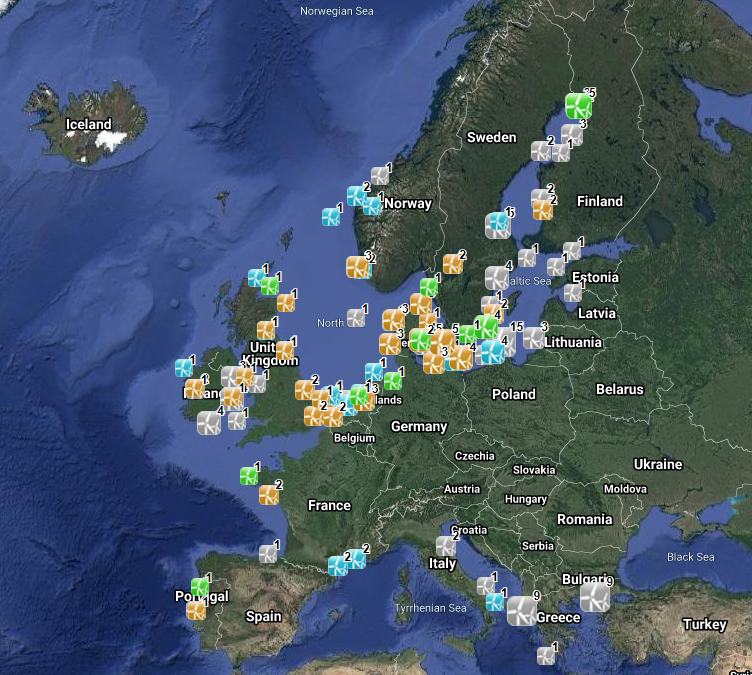
EMODnet_HA_WindFarms_20210217
The database on offshore wind farms in the EU was created in 2014 by CETMAR for the European Marine Observation and Data Network (EMODnet). It is the result of the aggregation and harmonization of datasets provided by several sources. It is updated every year and is available for viewing and download on EMODnet Human Activities web portal (www.emodnet-humanactivities.eu). The database contains points and/or (where available) polygons representing offshore wind farms in the following countries: Belgium, Denmark, Estonia, Finland, France, Germany, Greece, Ireland, Italy, Latvia, Lithuania, Netherlands, Norway, Poland, Portugal, Spain, Sweden and United Kingdom. Each point has the following attributes (where available): Name, Nº of turbines, Status (Approved, Planned, Dismantled, Construction, Production, Test site), Country, Year, Power (MW), Distance to coast (metres) and Area (square kilometres). The distance to coast (EEA coastline shapefile) has been calculated using the UTM WGS84 Zone projected coordinate system where data fall in.
Simple
- Date (Publication)
- 2014-06-01
- Date (Revision)
- 2021-02-17
- Date (Creation)
- 2014-06-01
- Identifier
- EMODnet, Human Activities, Wind Farms
- Credit
- European Marine Observation and Data Network
- GEMET - INSPIRE themes, version 1.0
-
- Energy resources
- GEMET - Concepts, version 2.4
-
- energy
- GEMET - Concepts, version 4.1.4
-
- wind power
- Mission Atlantic - Resources
-
- Data
- Mission Atlantic - BODC Parameters
-
- /Human activities/Energy
- Mission Atlantic - Work Package
-
- WP3 Pelagic Mapping
- WP4 Benthic Mapping
- Mission Atlantic - Data type (DMP)
-
- Spatial data products
- Mission Atlantic - Case Studies
-
- Celtic Seas
- Ocean Hackathon - City and challenge
-
- /Bournemouth
- /Brest
- /Cherbourg
- /La Rochelle
- /La Rochelle/LAR03
- /Toulon
- /Boulogne-sur-Mer
- /La Rochelle/LAR02
- /Cherbourg/CHE01
- Use limitation
- Re-use of content for commercial or non-commercial purposes is permitted free of charge, provided that the sources (both EMODnet - Human Activities, and primary sources) are acknowledged. EMODnet - Human Activities accepts no responsibility or liability whatsoever for the re-use of content accessible on its website.
- Access constraints
- Other restrictions
- Other constraints
- no limitation
- Denominator
- 100000
- Metadata language
- EnglishEnglish
- Topic category
-
- Economy
- Utilities communication
N
S
E
W
))
- Begin date
- 2014-06-01
- Distribution format
-
-
ESRI Shapefile
(
1.0
)
-
ESRI Shapefile
(
1.0
)
- OnLine resource
- http://www.emodnet-humanactivities.eu/ ( WWW:LINK )
- OnLine resource
- Data access ( WWW:LINK )
- Hierarchy level
- Dataset
Conformance result
- Date (Publication)
- 2008-12-04
- Explanation
- See the referenced specification
Conformance result
- Date (Publication)
- 2009-12-15
- Explanation
- See the referenced specification
Conformance result
- Date (Publication)
- 2010-12-08
- Explanation
- See the referenced specification
- Statement
- Data were retrieved from different countries, i.e. Belgium, Denmark, Estonia, Finland, France, Germany, Greece, Ireland, Italy, Latvia, Lithuania, Netherlands, Norway, Poland, Portugal, Spain, Sweden and United Kingdom. Validation and quality assurance remain up to primary data sources, while harmonization is carried out by CETMAR. Information obtained from local sources was cross-checked with information from The Wind Power (www.thewindpower.net) database. For further information on validation and quality assurance, it is suggested that primary data sources are contacted. Generally speaking data are to be considered very reliable, because they come from national sources officially in charge for their collection as well as from well-known private sources.
- File identifier
- EMODnet_HA_WindFarms_20210217 XML
- Metadata language
- EnglishEnglish
- Character set
- MD_CharacterSetCode_utf8
- Hierarchy level
- Dataset
- Date stamp
- 2023-10-31T16:49:36.521Z
- Metadata standard name
- ISO19115
- Metadata standard version
- 2003/Cor.1:2006
Overviews

Spatial extent
N
S
E
W
))
Provided by

Associated resources
Not available
 Catalogue PIGMA