 Catalogue PIGMA
2008
Type of resources
Available actions
Topics
Keywords
Contact for the resource
Provided by
Years
Formats
Representation types
Update frequencies
status
Scale
Resolution
-
Auteur(s): Lehembre Adrien , Projet de reconversion d'un bâtiment industriel situé en centre ville touristique en un centre culturel intégrant médiathèque, librairie ainsi que d'un lieu d'exposition à Bergerac (Dordogne)
-
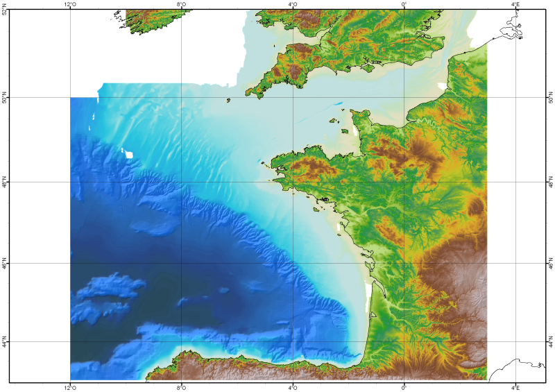
The Digital Terrain Model of the Bay of Biscaye and of the Channel is the result of the processing of a compilation of single and multibeam echosounder data, of DTMs and of chart countours produced before 2008 for hydrodynamic modeling..
-
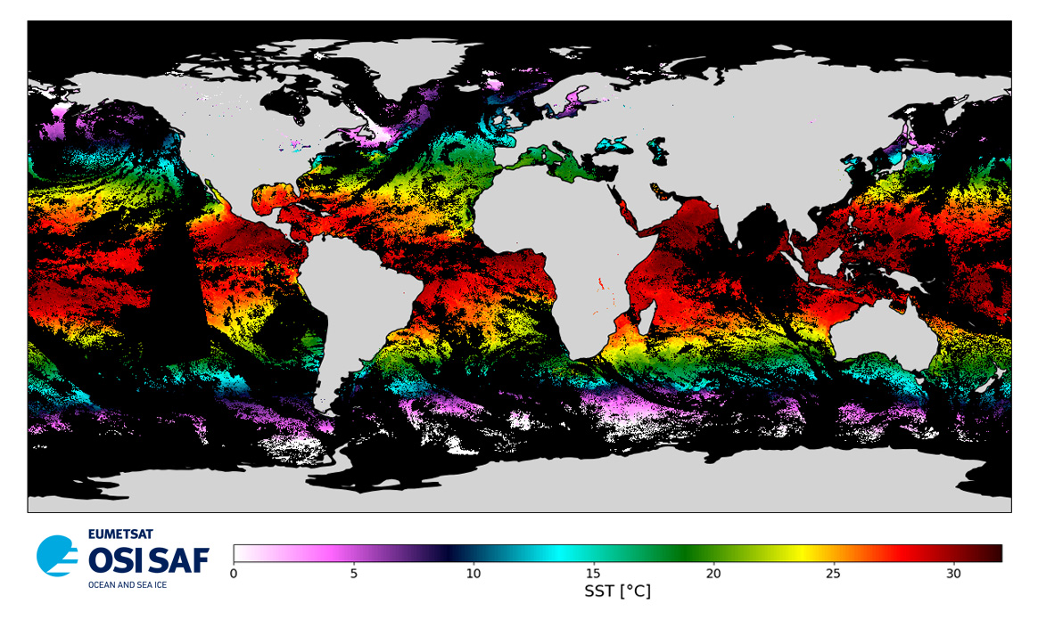
Level 3 twice-daily sub-skin Sea Surface Temperature derived from AVHRR on Metop-A, global and re-projected on a 0.05° regular grid, in GHRSST compliant netCDF format. The satellite input data has successively come from Metop-A and Metop-B level 1 data processed at EUMETSAT. SST is retrieved from AVHRR infrared channels (3.7, 10.8 and 12.0 µm) using a multi-spectral algorithm and a cloud mask. Atmospheric profiles of water vapor and temperature from a numerical weather prediction model, Sea Surface Temperature from an analysis, together with a radiative transfer model, are used to correct the multispectral algorithm for regional and seasonal biases due to changing atmospheric conditions.The quality of the products is monitored regularly by daily comparison of the satellite estimates against buoy measurements. The product format is compliant with the GHRSST Data Specification (GDS) version 2. Users are advised to use data only with quality levels 3, 4 and 5.
-
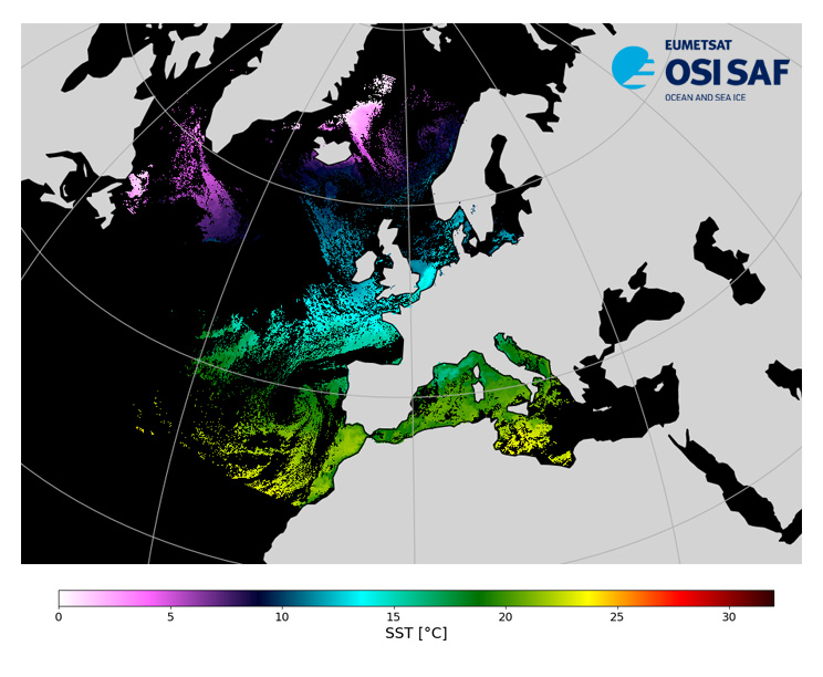
Level 3, four times a day, sub-skin Sea Surface Temperature derived from AVHRR on Metop satellites and VIIRS or AVHRR on NOAA and NPP satellites, over North Atlantic and European Seas and re-projected on a polar stereographic at 2 km resolution, in GHRSST compliant netCDF format. This catalogue entry presents Metop-A North Atlantic Regional Sea Surface Temperature. SST is retrieved from infrared channels using a multispectral algorithm and a cloud mask. Atmospheric profiles of water vapor and temperature from a numerical weather prediction model, Sea Surface Temperature from an analysis, together with a radiative transfer model, are used to correct the multispectral algorithm for regional and seasonal biases due to changing atmospheric conditions. The quality of the products is monitored regularly by daily comparison of the satellite estimates against buoy measurements. The product format is compliant with the GHRSST Data Specification (GDS) version 2.Users are advised to use data only with quality levels 3,4 and 5.
-
Isobathes numérisées à partir de scans 25 IGN couvrant la zone du Bassin d'Arcachon.
-
Découpage administratif de la France au niveau communal par départements
-
Carte Communale (CC) numérisée. Ce lot informe du droit à bâtir sur la commune de MONGAILLARD. Cette CC est numérisée conformément aux prescriptions nationales du CNIG.
-

Depuis septembre 2007, un programme de recherche est en cours sur le cycle du carbone dans le bassin d’Arcachon. Une des différentes actions menées dans ce projet consiste à comprendre et quantifier les flux de carbone organique et inorganique transportés par les rivières alimentant la lagune. Ce point a fait l’objet d’un échantillonnage bi-mensuel depuis entre février 2008 et février 2009. L’objectif est aussi de comparer le flux de carbone biogénique exporté par la nappe phréatique plioquaternaire dans le bassin versant Leyre-Arcachon avec la production primaire forestière du bassin versant et aquatique du Bassin d’Arcachon lui-même.
-
Carte Communale (CC) numérisée. Ce lot informe du droit à bâtir sur la commune de HAUTEFAYE. Cette CC est numérisée conformément aux prescriptions nationales du CNIG.
-
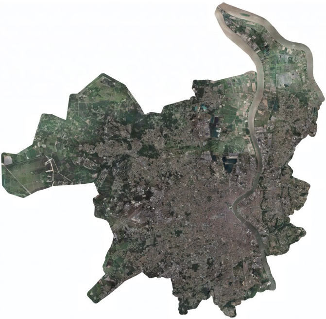
Cette base de données concerne des Orthophotographies au format Tiff. D'une résolution de 10cm (taille du pixel), elle a été constituée par INTERATLAS pour Bordeaux Métropole (La CUB en 2008) à partir de prises de vues aériennes de l'été 2008.