 Catalogue PIGMA
100000
Type of resources
Available actions
Topics
Keywords
Contact for the resource
Provided by
Years
Formats
Representation types
Update frequencies
status
Scale
Resolution
-
.jpg)
The Sir Alister Hardy Foundation for Ocean Science (SAHFOS) is an international charity that operates the Continuous Plankton Recorder (CPR) Survey. The dataset covers the North Atlantic and the North Sea on since 1958.
-
-

Frise chronologique des millésimes de modes d'occupation des sols produits par les régions françaises et par le programme Corine Land Cover.
-
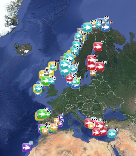
Location distribution per grid cell of 8 young harbor seals (Phoca vitulina), followed by Argos tags (between 2005 and 2008) along the English Channel coast following rehabilitation at the care center CHENE.
-

Aggregates map at 1 : 100 000 of the French metropolitan EEZ produced in the work-package 5 (coastline behavior) of the European project EMODnet Geology. This version of the dataset corresponds to the phase III of the project.
-
The database on marine finfish aquaculture in the EU was created in 2017 by AND-International for the European Marine Observation and Data Network (EMODnet). The dataset provides information about the location of marine finfish farms in the EU and partner countries where data are available. There is an obligation for EU MS to inventory all authorized aquaculture sites under the Council Directive 2006/88/EC on animal health requirements. Despite this obligation, the availability of data varies among MS from no data available at all to a complete regularly updated dataset (e.g.in Ireland). As far as partner countries are concerned, data have been collected only in Norway and the UK (Scotland only) at this stage, where detailed data are provided online. Data provided here cover Cyprus, Danmark, Finland, Greece, Ireland, Malta, Norway, Spain and the UK (Scotland only). Data collection is still undergoing in other EU MS and neighbouring countries. Each point has the following attributes (where available): Country, Owner name, Status (Active, Expired, Inactive, Renewal, n.a.), Farm type (Flatfish, Diversified farm, Other specialised farm, Salmon, Salmonids, Seabass-seabream, Trout,Tuna, n.a.), Production method (Sea cages, Saltwater tanks/raceways, Saltwater ponds, Saltwater closed (recirculation), Quarantine, Other, n.a.), Production stage (Grow out for human consumption, Hatchery, Nursery, Brood stock, Reproduction, Restoration of wild stock, Put and take fisheries, Processing facility, Salughtering facility, Other, n.a.), Purpose (Commercial, Restocking, Other, n.a.), Products detailed (detailed product information names as presented in the source and translated to English), Point information (Polygon centroid, Original) depending on how the information is provided in the source (polygons or points), Site_ID. The farm type relies on a typology established by AND-International, based on available information on species grown. A relational table provides harmonised information about species grown using Eurostat nomenclature for the Species Group (Cods, hakes, haddocks; Flounders, halibuts, soles; Miscellaneous coastal fishes, Miscellaneous demersal fishes; Miscellaneous pelagic fishes; Salmons, trouts, smelts;Tunas, bonitos, billfishes), the species name (commercial and scientific) and the code. Compared with the previous version this new version has been not only updated but was also reviewed (dataset schema and attributes values), in order to add information on production methods, production stages and purposes and to provide a more useful typology based on species grown.
-
-
-
The EEA coastline dataset is created for detailed analysis with a Minimum Mapping Unit of e.g. 1:100000, for geographical Europe. The coastline is a hybrid product obtained from satellite imagery from two projects: 1) EUHYDRO (Pan-European hydrographic and drainage database) [https://land.copernicus.eu/pan-european/satellite-derived-products/eu-hydro/view] and 2) GSHHG (A Global Self-consistent, Hierarchical, High-resolution Geography Database) [http://www.soest.hawaii.edu/pwessel/gshhg/]. The defining criteria was altitude level = 0 from EUDEM [https://land.copernicus.eu/pan-european/satellite-derived-products/eu-dem/view]. Outside the coverage of the EUDEM, the coastline from GSHHG was used without modifications. A few manual amendments to the dataset were necessary to meet requirements from EU Nature Directives, Water Framework Directive and Marine Strategy Framework Directive. In 2015, several corrections were made in the Kalogeroi Islands (coordinates 38.169, 25.287) and two other Greek little islets (coordinates 36.766264, 23.604318), as well as in the peninsula of Porkkala (around coordinates 59.99, 24.42). In this revision (v3, 2017), 2 big lagoons have been removed from Baltic region, because, according to HELCOM, are freshwater lagoons. This dataset is a polygon usable as a water-land mask.
-
