 Catalogue PIGMA
300000
Type of resources
Available actions
Topics
Keywords
Contact for the resource
Provided by
Years
Formats
Representation types
Update frequencies
status
Scale
-
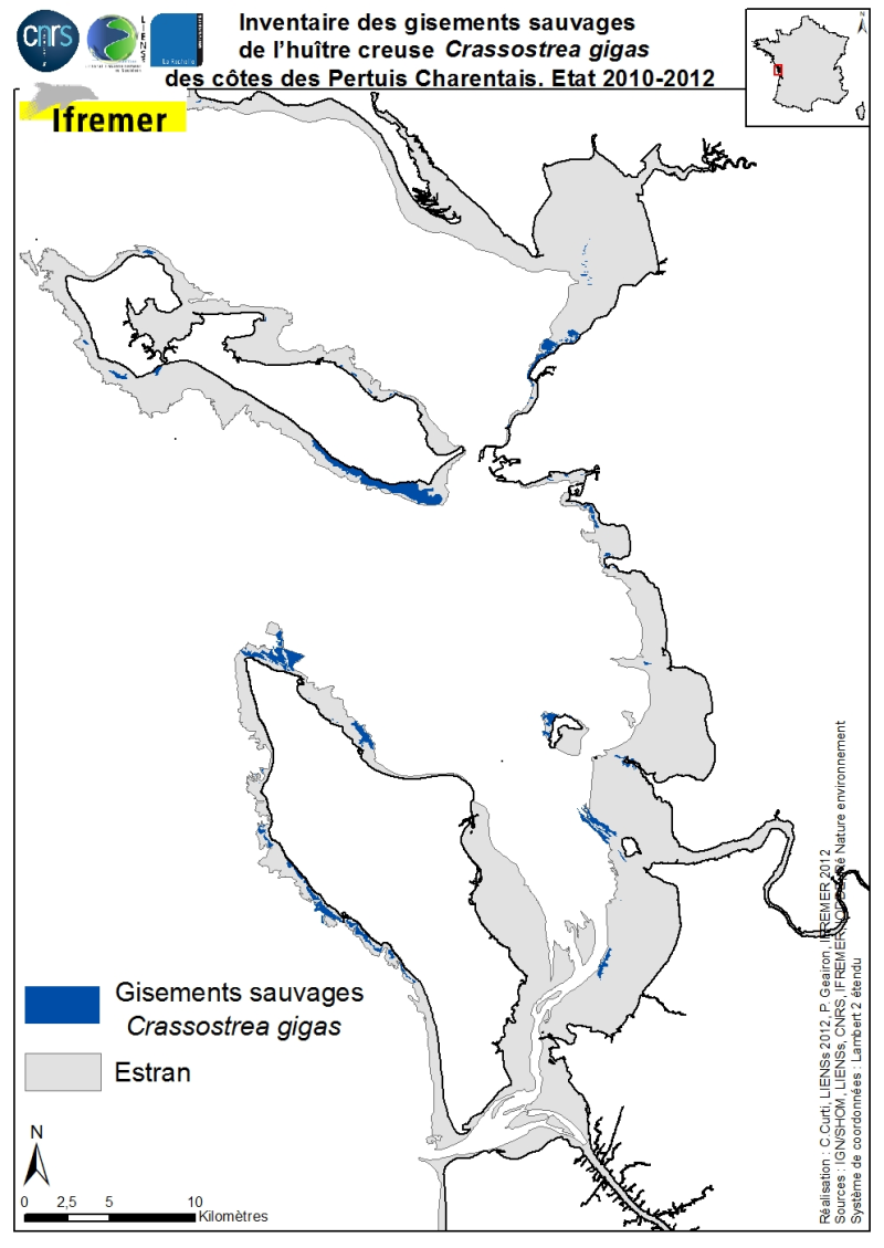
The geographical distribution of the main sources of wild Pacific oysters (Crassostrea gigas) (Thunberg, 1793) on the coasts of the Pertuis Charentais was compiled from 2010 to 2012. The inventory focuses on natural foreshore deposits (+ 6-0 m sea coast) and compiles two cartographic sources: 1) quantitative inventories made in 2010 by Ifremer from the Tranche sur Mer (Vendée) to Vaux-sur-Mer in 21 representative sites to estimate wild stocks of Pacific oysters and 2) inventory mapping of intertidal marine habitats mainly made by LIENSs (in cooperation with CREOCEAN, IODDE, Ré Nature Environnement and GEO-Transfert) under the project CARTHAM Natura 2000at sea of the Agency of Marine Protected Areas. Methodologies used by Ifremer to estimate the areas colonized combine thematic analysis in Geographic Information System (GIS) and field validations (Soletchnik et al., 2012). The methodologies used to estimate LIENSs extension of the intertidal habitat of the oysters combined aerial image analysis, remote sensing, field validations and thematic analysis using GIS (Cajeri et al., 2012).
-
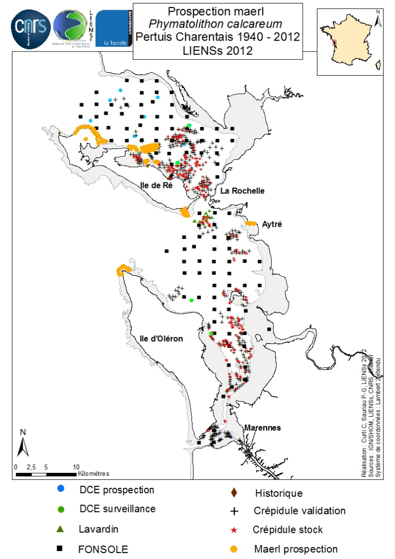
An inventory of mäerl ( unfixed red marine algae Corallinaceae with calcified arbuscular thalli) is taken in the Pertuis Charentais using the compilation of historical data and new observations over the period 2006-2012. The geographic extent of the inventory includes Pertuis Breton, Antioch and Maumusson, extends from the Lay estuary in the north to the Bay of Marennes-Oléron in the south and includes the edges of the islands of Ré, Oléron and Aix. Contributing to this inventory are, surveys DCE 2006 DCE, control monitoring DCE 2007 to 2012 under the aegis of Ifremer and Agences de l’Eau Loire-Bretagne and Adour-Garonne, surveys conducted for the Port Atlantique La Rochelle on the site of dredge spoil deposits in Lavardin from 2007 to 2012, surveys in 2007 FONSOLE by Ifremer and the surveys by Ifremer and laboratory LIENSs to map the crepidula stocks in the Pertuis Charentais Sea. Adding specific surveys conducted in 2011 by the ship Estran by dredge on subtidal bottom sediments of Pertuis Breton and intertidal quadrat in 2012 on the periphery of the islands of Ré, Oléron and along the cliffs of Aytré. The positioning of ground truthing stations were identified by GPS or dGPS. Initially identified by samples of the dredged material in October 2009 during the validation of sonar surveys to individualize stocks of crepidula, a live maerl bed is mapped in July 2011 in the harbor of Saint-Martin in Pertuis Breton. Its area is estimated at more than 2 km². Surveys of pedibus jambi conducted at the point of Grouin and Saint-Martin de Ré has confirmed the presence of live maerl scattered on the lower foreshore. This suggests a scattering of live maerl thalli of several tens of km² around the main bed of Saint-Martin. It is also confirmed by the single algological extraction of Phymatolithon calcareum done at the beginning of the twentieth century in Saint-Martin de Ré by Dollfus, probably already on the lower foreshore as observed in 2012 near the Couronneau beacon. Numerous dead maerl thalli in the procress of diagenesis have also been observed in the East and Southeast of Pertuis Breton and Antioch suggesting passive transport by contributions from live beds farther to the West, including Pertuis in Antioch. The presence of live maerl on the lower foreshore is seen very occasionally in the western islands of Oléron (Pointe Chassiron) and Ré (Phare des Baleines) via recent algologiques and fauna surveys. In biogeographic terms, the maerl bed of Pertuis Breton is the easternmost and southernmost of those known in the Bay of Biscay. The nearest mäerl beds known are respectively located in Noirmoutier (Bourgneuf Bay) and Galicia (Spain). These observations complement the atlas mapping of maerl populations in Europe published under the auspices of the OSPAR Convention. They provide a knowledge base for future conservation actions defined locally in the context of Natura 2000 Sea Marine Natural Park of the Gironde estuary and the Pertuis Charentais.
-
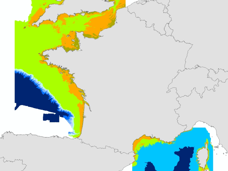
Theoretical Biological areas calculated from two meshed physical variables: bathymetry (resolution 100m), and attenuation of light in the water column (Kpar, resolution 250m). Coasts of mainland France. IFREMER Report "Hamdi Anouar, Vasquez Mickael, Populus Jacques (2010). Cartographie des habitats physiques Eunis - Côtes de France. IFREMER/AAMP agreement n° 09/12177764/FY. http://archimer.ifremer.fr/ doc/00026/13751/ "
-

Communes de Charente éligibles au programme Petites Villes de Demain. Petites villes de demain vise à améliorer les conditions de vie des habitants des petites communes et des territoires alentour, en accompagnant les collectivités dans des trajectoires dynamiques et respectueuses de l’environnement. Le programme a pour objectif de donner aux élus des villes et leurs intercommunalités de moins de 20 000 habitants exerçant des fonctions de centralités les moyens de concrétiser leurs projets de territoire.
-
-

Eunis-classified physical habitats physiques resulting from the combination of three physical variables meshed at a resolution of 100 metres: nature of the substrates, biological area, shearing tension on the sea floor. Coasts of mainland France. Ifremer report "Hamdi Anouar, Vasquez Mickael, Populus Jacques (2010). Cartographie des habitats physiques Eunis - Côtes de France. Ifremer/AAMP agreement n° 09/12177764/FY. http://archimer.ifremer.fr/ doc/00026/13751/ "
-
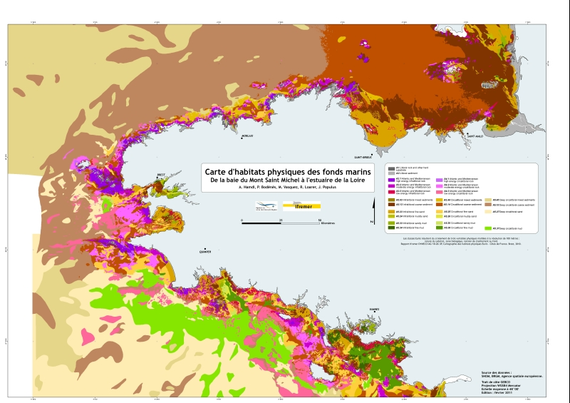
Eunis-classified physical habitats physiques resulting from the combination of three physical variables meshed at a resolution of 100 metres: nature of the substrates, biological area, shearing tension on the sea floor. Coasts of mainland France. Ifremer report "Hamdi Anouar, Vasquez Mickael, Populus Jacques (2010). Cartographie des habitats physiques Eunis - Côtes de France. Ifremer/AAMP agreement n° 09/12177764/FY. http://archimer.ifremer.fr/ doc/00026/13751/ "
-
-

Communes de la Charente ayant procédé à la mise en conformité de leur adressage des voies et numéros d'immeubles via le SIG Départemental. L’Agence technique de la Charente (ATD16) accompagne les communes qui en ont fait le choix, sur la réalisation et la création de leur adresses en créant une Base Adresse Locale (BAL).
-

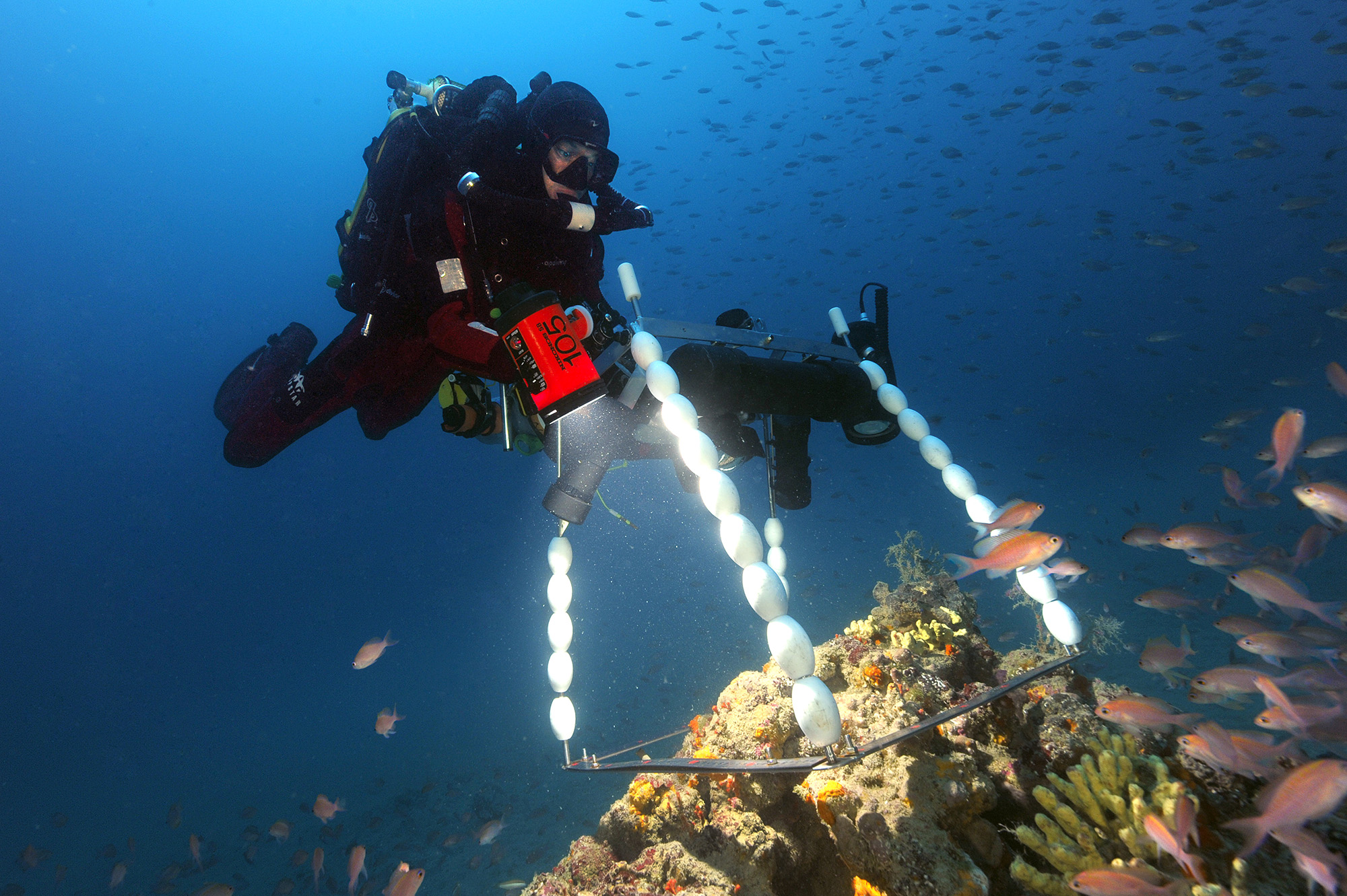
A la demande de l’Agence des Aires Marines Protégées, un inventaire cartographique des habitats des sites Natura 2000 en mer de l’estuaire de la Gironde et des Pertuis charentais a été réalisé afin d’établir un état initial de référence des milieux naturels. Est ici présenté l’inventaire cartographique dévolu aux zones intertidales meubles et rocheuses des Pertuis Charentais comprenant le littoral depuis la Tranche sur Mer jusqu’à Bonne Anse. S’inspirant des protocoles REBENT et MESH, trois méthodes complémentaires ont été combinées pour cartographier ces habitats intertidaux (Cajeri et al., 2012). Elles combinent les inventaires terrain avec relevés GPS différentiel, la télédétection couplant analyse d’ortho littorales et de scènes du satellite KOMPSAT-2 puis l’intégration sous système d’information géographique (SIG). Le rendu cartographique est basé sur la typologie EUNIS de niveau 4. Les structures délimitées sur photographies aériennes et validées par les inventaires terrain sont interprétées à partir de scènes satellite soumises à classification hiérarchique permettant une discrimination en termes de nature de sol, type de végétation et présence de mares. La compilation des informations est réalisée sous SIG en respectant les contraintes d’échelle et de topologie. Cette étude permet de combler un vide majeur de connaissances en particulier pour les habitats rocheux et les habitats d’espèces dans les Pertuis Charentais, les habitats de substrats meubles ayant été décrits par Hily (1976) et interprétés en typologie EUNIS par le REBENT. La carte proposée des habitats intertidaux n’est cependant pas définitive. Elle devrait bénéficier d’ajouts apportés à la typologie EUNIS par l’incorporation de nouveaux habitats en cours de validation à l’échelle européenne.