 Catalogue PIGMA
CSV
Type of resources
Available actions
Topics
Keywords
Contact for the resource
Provided by
Years
Formats
Representation types
Update frequencies
status
Scale
Resolution
-

This is the FAO Fishery and Aquaculture Reference Data repository: Codes and reference data for fishing gear, species, currencies, commodities, countries and others.
-
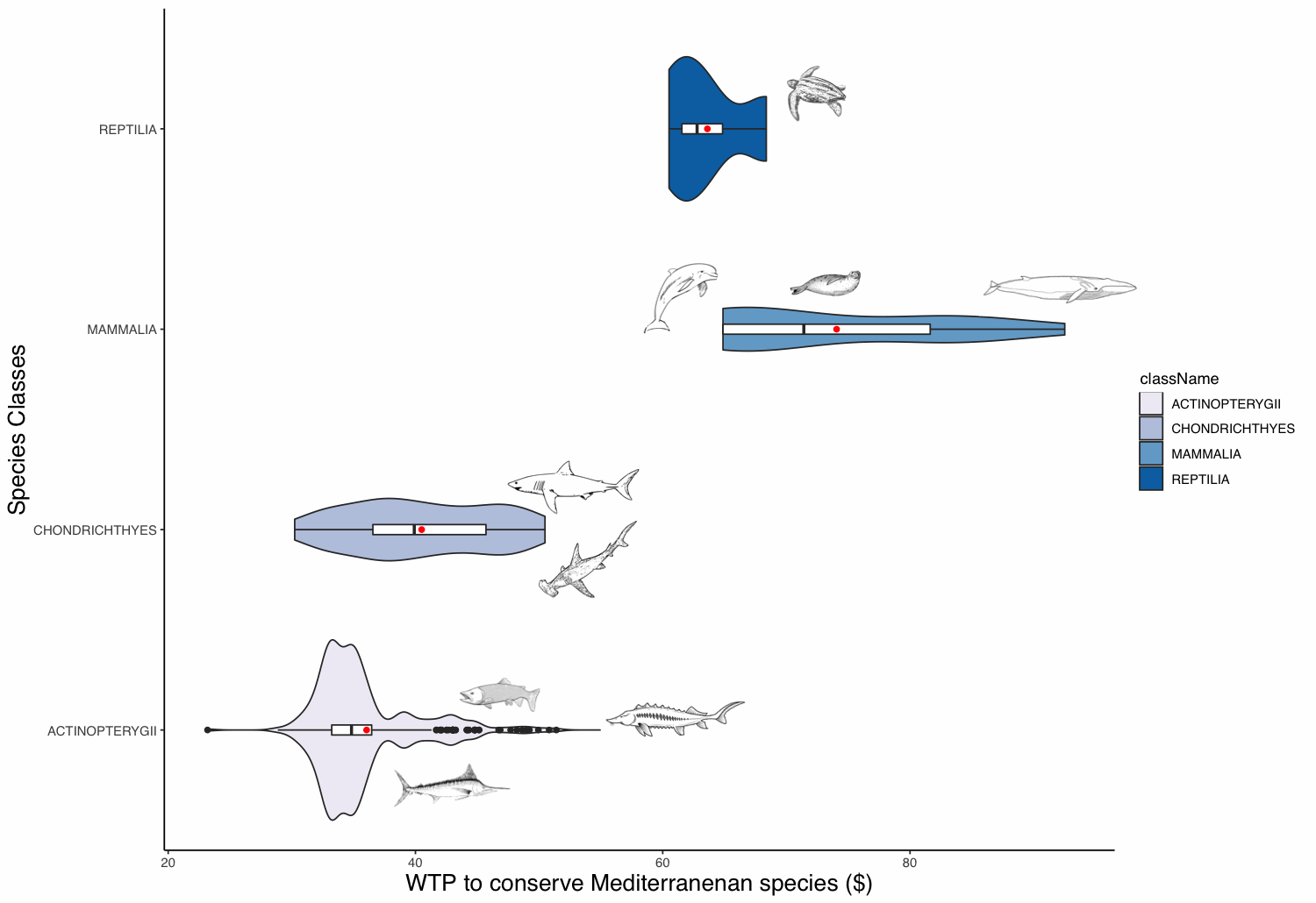
The willingness to pay (WTP) of people to protect animal populations can be used as a tool for these populations’ conservation. The WTP reflects the non-use value of animals, which can be significant for charismatic species. This value can be used as an economic criterion for decision-makers in order to recommend protective measures. The definition of the WTP to protect a species is challenging, as valuation methods are time-consuming and expensive. To overcome these limitations, we built a benefit transfer function based on 112 valuation studies and apply it to 440 Mediterranean marine species. We extracted these species from the IUCN database and retrieved some required parameters from, amongst others, the FishBase database. Marine mammals appear to have the highest WTP value followed in order by sea turtles, sharks and rays, and ray-finned fishes. Commercial fish species appear to have the highest values amongst the fish class.
-
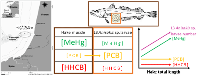
This dataset gathers isotopic ratios (carbon and nitrogen) and concentrations of both priority (mercury species and polychlorinated biphenyls congeners) and emerging (musks and sunscreens) micropollutants measured in a host-parasite couple (hake Merluccius merluccius muscle and in its parasite Anisakis sp) from the south of Bay of Biscay in 2018. In addition, the hake infection degree measured as the number of Anisakis sp. larvae was added for each hake collected.
-
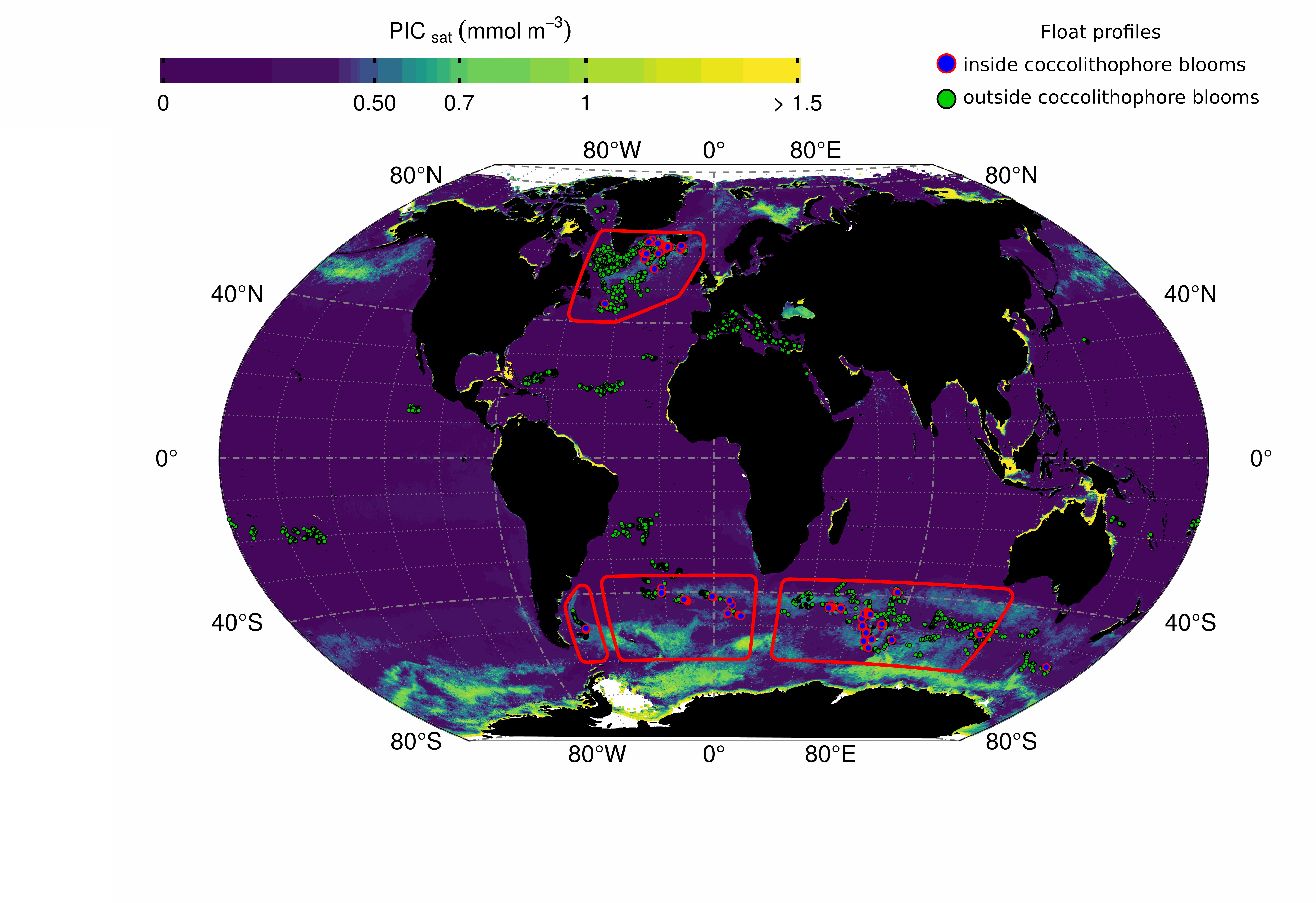
This dataset contains bio-optical measurements from BioGeoChemical-Argo (BGC-Argo) profiling floats complemented with ocean-colour satellite matchups of variables related to the detection of coccolithophore blooms dominated by Emiliania huxleyi. BGC-Argo float data cover the global ocean from November 2012 to December 2018 and include measurements of the particulate backscattering coefficient (BBP_float in m-1), the concentration of Chlorophyll-a (CHLA_float in mg m-3), and the particulate beam attenuation coefficient (CP_float in m-1) with data processing and quality control described in the manuscript entitled “Detection of coccolithophore blooms with BioGeoChemical-Argo floats” submitted to Geophysical Research Letters. The data represent near-surface ocean conditions, calculated as the average value in the top 15m of the water column. Daily ocean-colour satellite data were downloaded from the GlobColour project (ftp://ftp.hermes.acri.fr) with a spatial resolution of 4km and matched with every BGC-Argo float observation by using a 5x5 pixel box and a 9-day temporal window. For each float observation, we extracted concurrent satellite data of the concentrations of Particulate Inorganic Carbon (PIC_sat in mmol m-3) and Particulate Organic Carbon (POC_sat in mmol m-3), from which we derived the proportion of PIC_sat to the total particulate carbon concentration (PIC_POC_sat in % and defined as PIC_sat / [PIC_sat+POC_sat]). Coccolithophore bloom periods were identified using annual times series of PIC_sat and PIC_POC_sat at each profile location as described in the submitted manuscript, and the column “inside_coccolithophore_bloom” reports the float observations occurring inside such blooms.
-
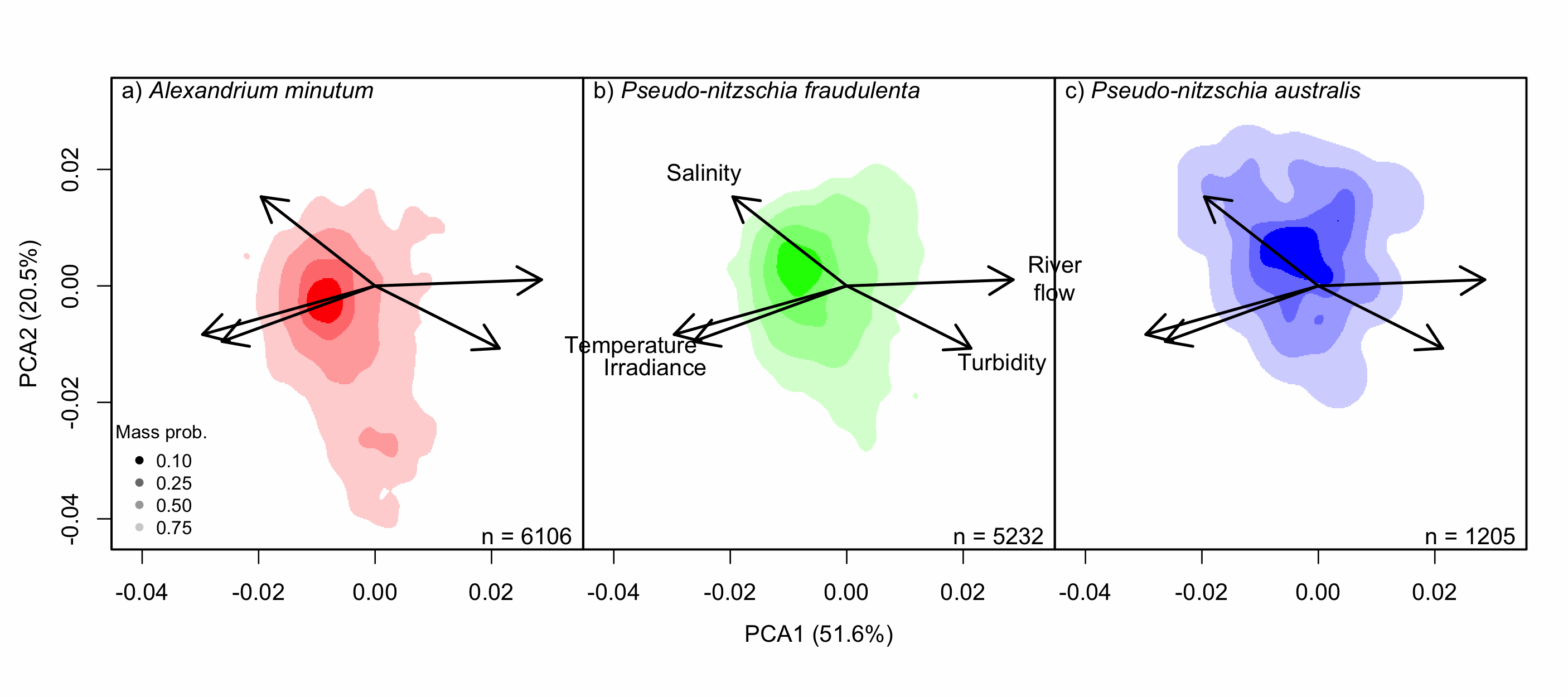
Understanding the spatial and temporal preferences of toxic phytoplankton species is of paramount importance in managing and predicting harmful events in aquatic ecosystems. In this study we address the realised niche of the species Alexandrium minutum, Pseudo-nitzschia fraudulenta and P. australis. We used them to highlight distribution patterns at different scales and determine possible drivers. To achieve this, we have developed original procedures coupling niche theory and habitat suitability modelling using abundance data in four consecutive steps: 1) Estimate the realised niche applying kernel functions. 2) Assess differences between the species’ niche as a whole and at the local level. 3) Develop habitat and temporal suitability models using niche overlap procedures. 4) Explore species temporal and spatial distributions to highlight possible drivers. Data used are species abundance and environmental variables collected over 27 years (1988-2014) and include 139 coastal water sampling sites along the French Atlantic coast. Results show that A. minutum and P. australis niches are very different, although both species have preference for warmer months. They both respond to decadal summer NAO but in the opposite way. P. fraudulenta realised niche lies in between the two other species niches. It also prefers warmer months but does not respond to decadal summer NAO. The Brittany peninsula is now classified as an area of prevalence for the three species. The methodology used here will allow to anticipate species distribution in the event of future environmental challenges resulting from climate change scenarios.
-

The SOMLIT-Antioche observation station, located at 5 nautical miles from Chef de Baie harbor (La Rochelle) is part of the French monitoring network SOMLIT (https://www.somlit.fr/), accredited by the INSU-CNRS as a national Earth Science Observatory (Service National d’Observation : SNO), which comprises 12 observation stations distributed throughout France in coastal locations. It aims to detect long-term changes of these ecosystems under both natural and anthropogenic forcings. SOMLIT is part of the national research infrastructure for coastal ocean observation ILICO (https://www.ir-ilico.fr/?PagePrincipale&lang=en). The SOMLIT-Antioche station (46.0842 °N, 1.30833 °W) is located in the north-eastern part of the Bay of Biscay, halfway between the islands of Ré and Oléron, at the centre of what is commonly known as the Pertuis Charentais area, which correspond to a semi-enclosed shallow basin and includes four islands (Ré, Oléron, Aix and Madame) and three Pertuis (i.e., detroit) (Breton, Antioche and Maumusson). This 40m-deep site, with muddy to sandy marine bottoms, is submitted to a macro-tidal regime and is largely open to the prevailing westerly swells. It remains under a dominant oceanic/neritic influence, even though its winter/spring hydrological context is influenced by the diluted plumes of the Charente, Gironde and Loire rivers, but not by those of too small estuaries (Lay, Seudre and Sèvre Niortaise). SOMLIT-Antioche hydrological monitoring has been carried out by the LIENSs/OASU laboratory on a fortnightly basis since June 2011. Surface water samples are collected at high-tide during intermediate tides (70 ± 10 in SHOM units) on board the research vessel ‘L’Estran’ owned by La Rochelle University. Samples are analyzed for more than 16 core parameters: temperature, salinity, dissolved oxygen, pH, ammonia, nitrates, nitrites, phosphates, silicates, suspended matter, particulate organic carbone, particulate organic nitrogen, chlorophyll, delta15N, delta13C; pico- and nano- plankton. Measurements are carried out in accordance with the ISO/IEC 17025:2017 standard. Simultaneous monitoring of the micro-phytoplankton community (since 2013, SNO PHYTOBS: https://www.phytobs.fr/en) and monitoring of prokaryotic communities (Bacteria and Archaea) are also carried out on a monthly basis. Since 2019, seasonal observations of benthic invertebrate communities (SNO BenthObs : https://www.benthobs.fr/) have also been carried out. This monitoring is complementary to that carried out at hydrological stations in the pre-existing REPHY and DCE networks, some of which are located near marine farming areas (oyster and mussel farms).
-
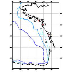
210Pb, 226Ra and 137Cs were measured by non-destructive gamma spectrometry on marine sediment cores, collected during RIKEAU 2002 cruise on board r/v Thalia, on the shelf of the Bay of Biscay
-
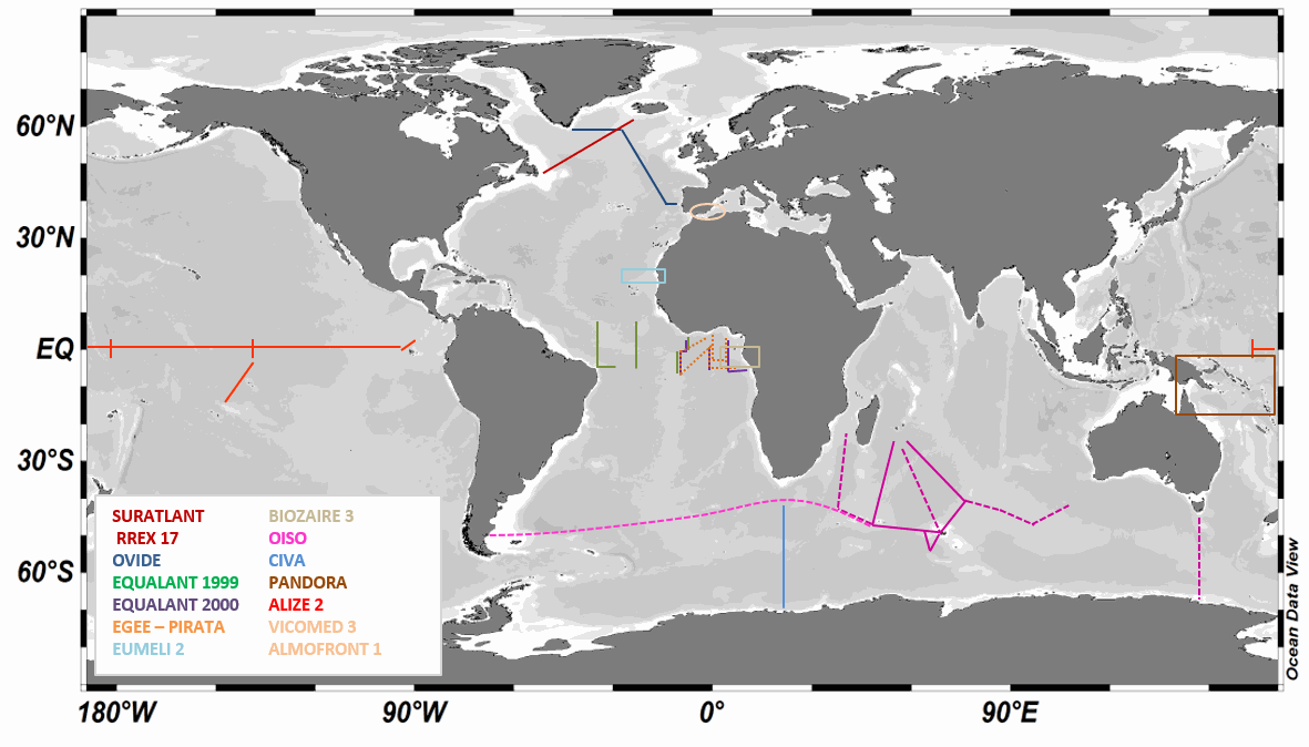
LOCEAN has been in charge of analyzing the isotopic composition of the dissolved inorganic carbon (DIC) in sea water collected during a series of cruises or ships of opportunity mostly in the southern Indian Ocean , the North Atlantic, and the equatorial Atlantic, but also in the Mediterranean Sea and in the equatorial Pacific. The LOCEAN sea-water samples for δ13CDIC were collected in 125/25 ml glass bottles until 2022/since then and poisoned with HgCl2 (1 ml of saturated solution) before storage in a dark room à 4°C until their measurement. The DIC was extracted from the seawater by acidification with phosphoric acid (H3PO4 85%) and CO2 gas that was produced was collected in a vacuum system following the procedure described by Kroopnick (1974). The isotopic composition of CO2 was determined using a dual inlet-isotopic ratio mass spectrometer (SIRA9-VG) by comparing the 13C/12C ratio of the sample to the 13C/12C ratio of a reference material, the Vienna-Pee Dee Belemnite (V-PDB). The isotopic composition is expressed in the δ-unit defined by Craig (1957)(method type 2). Experience showed that samples older than 3-4 years are likely to have experienced conservation issues and have been dismissed. The mass spectrometer has worked very well until 2014-2015. Afterwards, its aging as well as the aging of the preparation line resulted in more data loss, and often less accurate results. The preparation line was renovated in 2019, and analyses in 2020 were run manually, often repeating the measurement a second time for each sample. Up to 2007-2008, δ13CDIC values have a precision of±0.01 ‰ (Vangriesheim et al.,2009) and a reproducibility of±0.02 ‰. After an interlaboratory comparison exercise led by Claire Normandeau (Dalhousie University), results suggest that recent LOCEAN samples have a slightly poorer reproducibility (±0.04 ‰ ) as well as an offset of -0.13‰ (details available in Reverdin et al., ESSD 2018) that is confirmed by Becker et al. 2016 work by comparison with other cruises after removing the anthropogenic signal. Recent comparisons in early May 2021 with Orsay GEOPS facility samples suggest that the current offset is much smaller and might be +0.03‰. LOCEAN has installed in 2021 a new measurement device by coupling a Picarro G2131-I cavity ring down spectrometer (CRDS) with a CO2 extractor (Apollo SciTech) that will measure at the same time DIC (method type 3) (Leseurre, 2022). Since then, all water samples have been analyzed on this device. Part of the data set, as well as a scientific context and publications are also presented on the WEB site https://www.locean-ipsl.upmc.fr/oceans13c. Individual files correspond to regional subsets of the whole dataset. The file names are based on two letters for the region followed by (-) the cruise or project name (see below) followed by –DICisotopes, followed by either -s (surface data) or -b (subsurface data), and a version number (-V0, …): example SI-OISO-DICisotopes-s-V0; the highest version number corresponds to the latest update of the cruise/project data set, and can be directly downloaded. Earlier versions can be obtained on request, but are not recommended. The region two letters are the followings: - SI: station and surface data in the Southern Indian Ocean that include cruises : INDIGO I (1985 – stn) (https://doi.org/10.17600/85000111) CIVA I (1993 – stn & surf) (https://doi.org/10.17600/93000870) (Archambeau et al., JMS 1998) ANTARES (1993 – stn & surf) (https://doi.org/10.17600/93000600) OISO (*) (since 1998 – stn & surf) (https://doi.org/10.18142/228) (Racapé et al., Tellus 2010, Leseurre, 2022) - EA: station and surface data in the Tropical Atlantic Ocean that include cruises : EQUALANT (1999 & 2000 – surf) (https://doi.org/10.18142/98) EGEE (2005 to 2007 – stn & surf) (https://doi.org/10.18142/95) PIRATA (since 2013 – stn & surf) (https://doi.org/10.18142/14) EUMELI 2 (1991 – stn) (https://doi.org/10.17600/91004011) (Pierre et al., JMS 1994) BIOZAIRE 3 (2003 – stn & surf ) (https://doi.org/10.17600/3010120) (Vangriesheim et al., DSRII, 2009) TARA-Microbiomes (2021 - stn & surf) - NA : station and surface data in the North Atlantic Subpolar gyre that include cruises : OVIDE (**) (since 2002 – stn & surf) (https://doi.org/10.17882/46448) (Racapé et al., 2013) RREX (2017 – stn & surf) (https://doi.org/10.17600/17001400) SURATLANT (since 2010 - surf) (https://doi.org/10.17882/54517) (Racapé et al., BG 2014 ; Reverdin et al., ESSD 2018, Leseurre, 2022) NUKATUKUMA (since 2017- surf) - MS: station data in the Mediterranean sea that include cruises : ALMOFRONT 1 (1991 – stn) (https://doi.org/10.17600/91004211) VICOMED 3 (1990 – stn) (https://doi.org/10.17600/90000711) - PO: tropical Pacific that include cruises : PANDORA (2012 – stn) (https://doi.org/10.17600/12010050) ALIZE2 (1991 – stn & surf) (https://doi.org/10.17600/91002711) (Laube-Lenfant and Pierre, Oceanologica Acta 1994) - SO: station and surface data in the Southern Ocean (except OISO) that include cruises: TARA-Microbiomes (2021-2022, stn & surf) AGULHASII-072022 (2022, stn) CONFLUENCE (1993-1994, stn) - AO: station and surface data in the Arctic Ocean and nearby seas that include cruises: GREENFEEDBACK (2024, stn&surf) TCA (2024, stn) REFUGE ARCTIC (2024, stn) (*) The values for cruises OISO19, 21 and 22 are doubtful (for some, too low) and will require further investigation to find whether adjusted values can be proposed. (**) Some of the OVIDE cruises are also referred to as or GEOVIDE (in 2014), and BOCATS (in 2016). CATARINA, BOCATS1 and BOCATS2 (PID2019-104279GB-C21/AEI/10.13039/501100011033) cruises were funded by the Spanish Research Agency The values of the OVIDE 2010 stations are doubtful (too low), but no particular error was found, and they have been left in the files. Data The files are in csv format reported as: - Cruise name, station id, (bottle number), day, month, year, hour, minute, longitude, latitude, pressure (db), depth (m), temperature (°C), temperature qc, salinity (pss-78), salinity qc, d13CDIC, d13CDIC qc, method type - Temperature is an in situ temperature - Salinity is a practical salinity - Method type (1) acid CO2 extraction from helium stripping technique coupled to mass spectrometer, (2) acid CO2 extraction in a vacuum system coupled to mass spectrometer,(3) CO2 extractor (Apollo SciTech) coupled to CRDS measurements. Temperature qc, salinity qc, d13CDIC qc are quality indices equal to: - 0 no quality check (but presumably good data) - 1 probably good data - 2 good data - 3 probably bad data - 4 certainly bad data - 9 missing data (and the missing data are reported with an unlikely missing value)
-
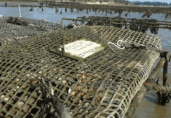
Rocch, the french "mussel watch", provides regulatory data for shellfish area quality management. Once a year, molluscs (mainly mussels and oysters) were sampled at fixed periods (currently mid-February, with a tolerance of one tide before and after the target date) on 70 to 80 monitoring stations in areas used as bivalve molluscs production. For each monitoring station, molluscs are collected in wild beds or facilities, ensuring a minimum stay of 6 months on-site before sampling. The individuals selected are adults of a single species and uniform size (30 to 60 mm long for mussels, 2 to 3 years old for oysters, and commercial size for other species). A minimum of 50 mussels (and other species of similar size) or 10 oysters is required to constitute a representative pooled sample. Lead, mercury, cadmium, PAHs, PCBs, dioxins and, since 2023, regulated PFASs are analysed in molluscs tissues.
-
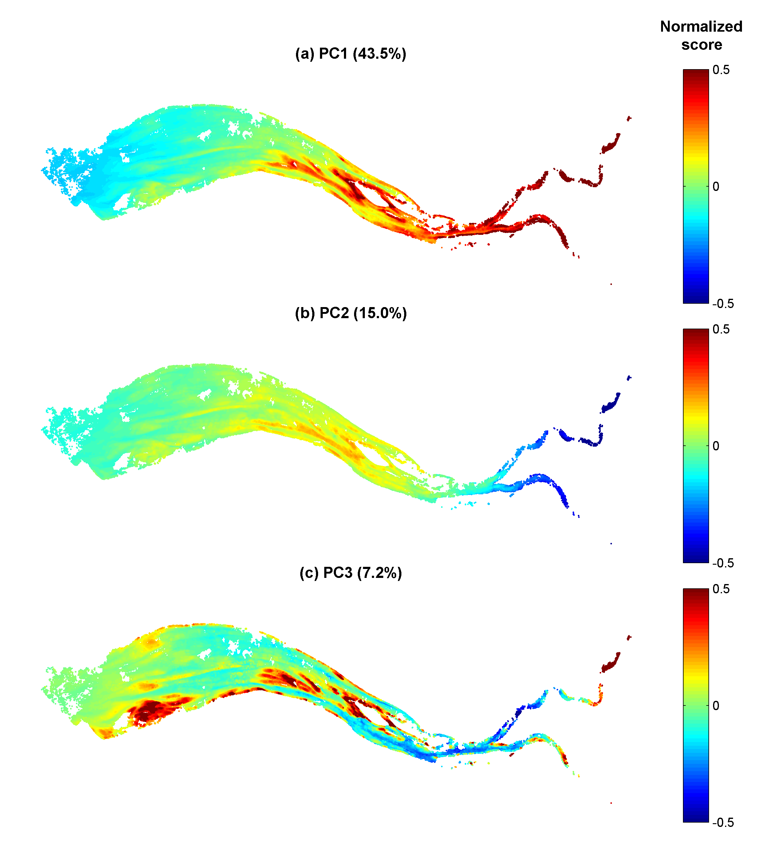
Gironde estuary environmental parameters and SPM maps generated from 41 Landsat-8/OLI and Sentinel-2/MSI images acquired over the period 2013-2018. Except bathymetry and daily river discharge data, that are accessible on public platforms, the dataset includes all of the time seris used in the publication: Analysis of suspended sediment variability in a large highly-turbid estuary using a 5-year-long remotely-sensed data archive at high resolution, Journal of Geophysical Research: Oceans, DOI:10.1029/2019JC015417.