 Catalogue PIGMA
XLS, XLSX
Type of resources
Available actions
Topics
Keywords
Contact for the resource
Provided by
Years
Formats
-

Sardine physiological measurments from september to november 2020
-
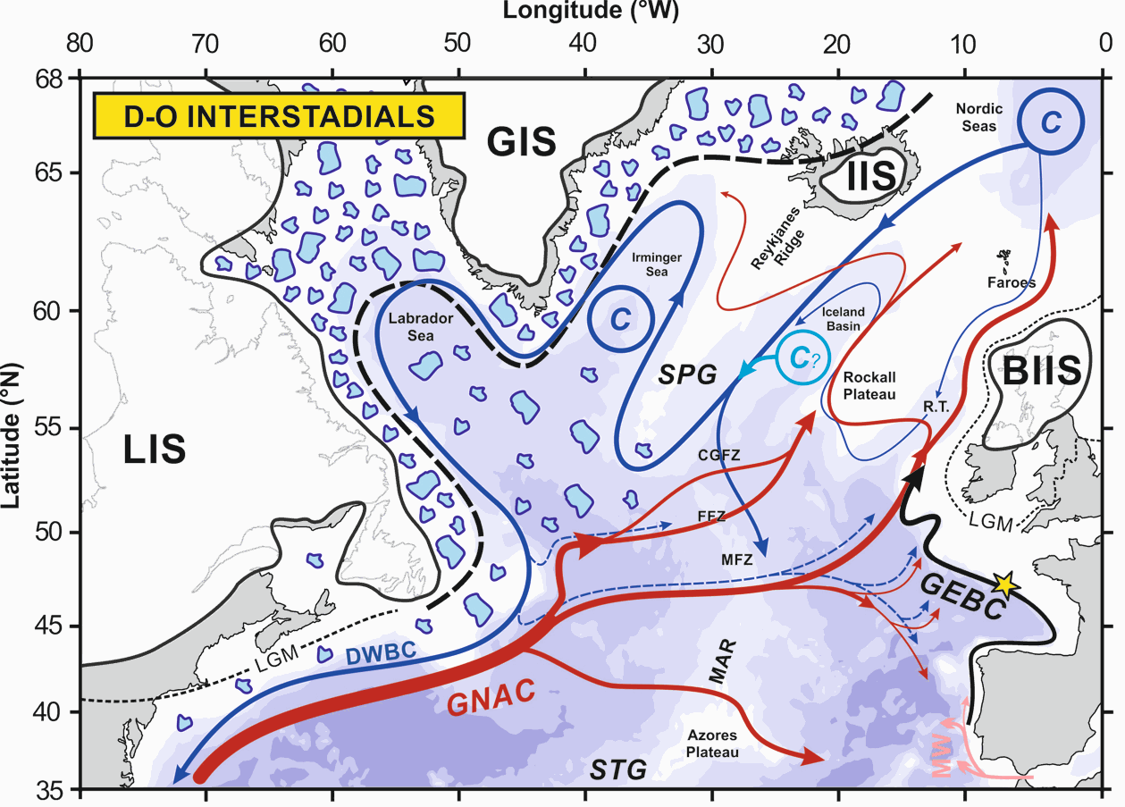
The upper branch of the Atlantic Meridional Overturning Circulation (AMOC) plays a critical role in ocean circulation and climate change, yet its variability during the last glacial period is poorly documented. Here, we investigate the northward-flowing Glacial Eastern Boundary Current (GEBC) in the North Atlantic, known today as the European Slope Current, and representing the easternmost portion of the upper branch of the AMOC. Based on flow speed (sortable silt, XRF) and radiogenic/stable isotopic records, we show that Dansgaard-Oeschger (D/O) interstadials (stadials) correspond to a faster (weaker) GEBC during the ~50-15 ka period. This, by analogy to present-day conditions, suggests enhanced (reduced) strength of the subpolar gyre and, by extension, of northern-sourced water production and AMOC during D-O interstadials (stadials). Concomitant fluctuations of both the European Ice Sheet and the GEBC between ~30 and 17 ka suggest an active role of the upper branch of AMOC in the poleward transport of heat and freshwater to the northern North Atlantic, with direct impacts on deep water formation and AMOC strength. Our GEBC reconstruction is the first physical (non-chemical) record documenting dynamic upper AMOC variability at high resolution in the eastern basin of the North Atlantic. Together with the deep North Atlantic records of northern-sourced water export, they confirm the central role of the AMOC in the generation of abrupt climate changes.
-

As part of the European Horizon Europe FOCCUS project (https://foccus-project.eu/), the metadata inventory of European coastal platforms has been extracted. The inventory was based on the following History and Latest products, downloaded from the CMEMS website (https://marine.copernicus.eu/fr/acces-donnees) at: 1) Global Ocean-In-Situ Near-Real-Time Observation, 2) Atlantic Iberian Biscay Irish Ocean-In-Situ Near Real Time Observations, 3) Mediterranean Sea-In-Situ Near Real Time Observations, 4) Atlantic-European North West Shelf-Ocean In-Situ Near Real Time Observations. To carry out this inventory, it was decided to target only coastal platforms, located less than 200km from the coast and at a depth of less than 400m. For mobile platforms, it was also decided to focus only on the first position in the file. This data must be located within 200 km of the coast and at a depth of less than 400 m. In this inventory, FerryBox platforms have all been considered as coastal platforms. The following platforms were extracted from the products: BO (Bottles), CT (CTD), DB (Drifting Buoys), FB (Ferry Box), GL (Gliders), HF (High Frequency Radar), MO (Mooring), PF (Profiling Float), TG (Tide Gauge) and XB (XBT). Once the metadata had been extracted from the files, duplicates were removed (files with the same names). Duplicate platforms of type _TS_ and _WS_ were merged (date and parameters). Latest‘ files have been merged with ’History" files. Missing metadata have been replaced in the Excel file by ‘Missing Data’. Some old dates were also revised by hand because they had been badly extracted, as well as some institution names that included special characters. Platforms located on estuaries/rivers/lakes/ponds have also been removed by hand. This inventory identified a total of 10,479 coastal platforms.
-
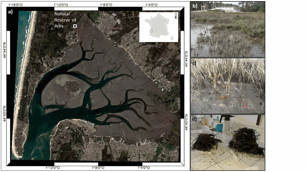
The ARCHYD dataset, which have been collected since 1988, represents the longest long-term hydrologic data sets in Arcachon Bay. The objectives of this monitoring programme are to assess the influence of oceanic and continental inputs on the water quality of the bay and their implications on biological processes. It also aims to estimate the effectiveness of management policies in the bay by providing information on trends and/or shifts in pressure, state, and impact variables. Sampling is carried on stations spread across the entire bay, but since 1988, the number and location of stations have changed slightly to better take into account the gradient of ocean and continental inputs. In 2005, the ARCHYD network was reduced to 8 stations that are still sampled by Ifremer to date. All the stations are sampled at a weekly frequency, at midday, alternately around the low spring tide and the high neap tide. Data are complementary to REPHY dataset. Physico-chemical measures include temperature, salinity, turbidity, suspended matters (organic, mineral), dissolved oxygen and dissolved inorganic nutrients (ammonium, nitrite+nitrate, phosphate, silicate). Biological measures include pigment proxies of phytoplankton biomass and state (chlorophyll a and phaeopigment).
-
Ifremer conducts numerous fisheries surveys dedicated to benthic and demersal populations (commercial / non-commercial fishes and invertebrates). For several years, in application of the ecosystem approach, all benthic invertebrate fauna collected in fishing gear has been systematically monitored: megabenthic invertebrates captured have been sorted, identified, counted and weighted. All these surveys are based on fixed or random stratified sampling strategy with varying intensity depending on the covered survey area. These data are stored, in historical access-based databases or for the most recent years in the centralised “Harmonie” database held in the Ifremer Fishery Information Systeme (SIH). The species nomenclature used was standardized using WoRMS database. Taxa caught at least once a year are listed for each monitoring area on the basis of already available data series. In order to facilitate the identification of individuals sampled on board vessels and to improve the training of onboard scientists, the present work aims to define the minimum level of identification for each of them. The analysis identifies taxa that appears recurrently on available historical series or gathers them on less precise taxonomic levels if this is not the case, which may indicate potential identification difficulties. The following procedure was used: all taxa expressed at the species level were first aggregated at genus level if they occurred less 90% of the years over the available time series. For MEDITS, EPIBENGOL and ORHAGO, the occurrence threshold was set to 70% and to only 50% for NOURMONT because the datasets were less than 10 years long. Then to be kept at that taxonomic level, a given genus had to be observed over 90% of the time (for example over at least 9 years if the dataset contains 10 years). Otherwise it was iteratively regrouped into a higher taxonomic level (family, order, class, division) following the same criteria (Foveau et al, 2017). For instance, for the NOURSEINE survey, this resulted into the aggregation of the 103 origin taxa into 35 taxonomic groups. The name of the final taxon after data processing represents the minimum level of identification defined by the analysis. However, these results are very theoretical. This is why they were sent to scientists who embark regularly in order to refine the level of taxonomic identification with field experience. The first dataset is composed of 8 tables relevant to the different vessel surveys. The first column of each table represents the permanent code of the taxon in the Ifremer taxonomic referential, the second the systematic number and the third the species abbreviated code. The other columns are the different taxonomic levels of the taxon. The minimum level of identification at sea defined by the data processing appears in blue. The level determined by feedback of scientist’s field experience, which is the one to use at sea, appears in green. The second dataset summaries the results detailed in the first table and indicates directly for each taxon identified to far, the minimum level of identification required for the benthic invertebrates by-catch of each fisheries surveys studied.
-
Questions: Invasiveness depends in part on the ability of exotic species to either exclude native dominants or to fill an empty niche. Comparisons of niches and effects of closely related native and invasive species enable the investigation of this topic. Does Spartina anglica invade European salt marshes through competitive exclusion of the native Spartina maritima or due to the occurrence of an empty ecological niche in highly anoxic conditions? Location: The Arcachon Bay (France). Methods: At three intertidal levels, we quantified competitive response and effect abilities of the two species through a cross-transplantation removal experiment. We also compared at three intertidal levels the biomass, root/shoot ratio, productivity and environmental conditions (elevation, salinity, potential redox and soil moisture) of salt marsh communities dominated by the exotic Spartina anglica or the native Spartina maritima. Results: Both established species showed similar biotic resistance to the invasion of the other species, but the exotic showed important intraspecific facilitation for growth. Species had similar niches and total biomass along a gradient of anoxic conditions, but the exotic had a much higher root/shoot ratio and productivity than the native. Owing to its rhizome density, the exotic showed a high ability to increase sediment oxygenation, likely to explain its important intraspecific facilitation. Conclusions: Our results showed that the invasion success of S. anglica cannot be explained by the competitive exclusion of the native or by its ability to fill an empty niche along a gradient of anoxia. Its behaviour as a self-facilitator invasive engineer is very likely to explain its rapid spread in the Bay and biotic resistance to the colonization of other congeneric species when established in dense patches. Additionally, we suggest that physical disturbance in the marsh communities dominated by the native S. maritima may disrupt its biotic resistance against the invasion of S. anglica.
-
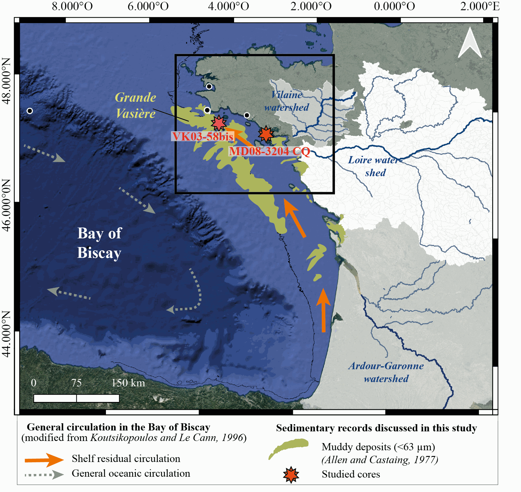
New results acquired in south-Brittany (MD08-3204 CQ core: Bay of Quiberon and VK03-58bis core: south Glénan islands) allow depicting Holocene paleoenvironmental changes from 8.5 ka BP to present through a multi-proxy dataset including sedimentological and palynological data. First, grain-size analyses and AMS-14C dates highlight a common sedimentary history for both study cores. The relative sea level (RSL) slowdown was accompanied by a significant drop of the sedimentation rates between ca. 8.3 and 5.7 ka BP, after being relatively higher at the onset of the Holocene. This interval led to the establishment of a shell-condensed level, identified in core VK03-58bis by the “Turritella layer” and interpreted as a marker for the maximum flooding surface. Palynological data (pollen grains and dinoflagellate cyst assemblages) acquired in core MD08-3204 CQ argue for an amplification of the fluvial influence since 5.7 ka BP; the establishment of the highstand system tract (i.e., mixed marine and fluviatile influences on the platform) then accompanying the slowdown of the RSL rise-rates. On the shelf, the amplification of Anthropogenic Pollen Indicators (API) is then better detected since 4.2 ka BP, not only due to human impact increase but also due to a stronger fluvial influence on the shelf during the Late Holocene. Palynological data, recorded on the 8.5–8.3 ka BP interval along an inshore-offshore gradient, also demonstrate the complexity of the palynological signal such as i) the fluvial influence that promotes some pollinic taxa (i.e., Corylus, Alnus) from proximal areas and ii) the macro-regionalization of palynomorph sources in distal cores. In addition, the comparison of palynological tracers, including API, over the last 7 kyrs, with south-Brittany coastal and mid-shelf sites subjected to northern vs. southern Loire catchment areas, allowed discussing a major hydro-climatic effect on the reconstructed palynological signals. Strengthened subpolar gyre dynamics (SPG), combined with recurrent positive North Atlantic Oscillation (NAO) configurations, appear responsible for increased winter precipitations and fluvial discharges over northern Europe, such as in Brittany. Conversely, weakened SPG intervals, associated with negative NAO-like modes, are characterized by intensified winter fluvial discharges over southern Europe. Interestingly, we record, at an infra-orbital timescale, major peaks of API during periods of strengthened (/weakened) SPG dynamics in sites subjects to Brittany watersheds (/Loire watersheds) inputs.
-
Particularly suited to the purpose of measuring the sensitivity of benthic communities to trawling, a trawl disturbance indicator (de Juan and Demestre, 2012, de Juan et al. 2009) was proposed based on benthic species life history traits to evaluate the sensibility of mega- and epifaunal community to fishing pressure known to have a physical impact on the seafloor (such as dredging and bottom trawling). The selected biological traits were chosen as they determine vulnerability to trawling: mobility, fragility, position on substrata, average size and feeding mode that can easily be related to the fragility, recoverability and vulnerability ecological concepts. Life history traits of species have been defined from the BIOTIC database (MARLIN, 2014) and from information given by Le Pape et al. (2007), Brindamour et al. (2009) and Garcia (2010). For missing life history traits, additional information from literature has been considered. The five categories retained are life history functional traits that were selected based on the knowledge of the response of benthic taxa to trawling disturbance (de Juan and Demestre, 2012). They reflect respectively the possibility to avoid direct gear impact, to benefit from trawling for feeding, to escape gear, to get caught by the net and to resist trawling/dredging action, each of these characteristics being either advantageous or sensitive to trawling. Then, to allow quantitative analysis, a score was assigned to each category: from low vulnerability (0) to high vulnerability (3). The five categories scores were then summed for each taxon (the highly vulnerable taxon could reach the maximum score is 15) and this value may be considered as a species index of sensitivity to trawling disturbance. The scores of 812 taxa commonly found in bottom trawl by-catch in the southern North Sea, English Channel and north-western Mediterranean were described.
-
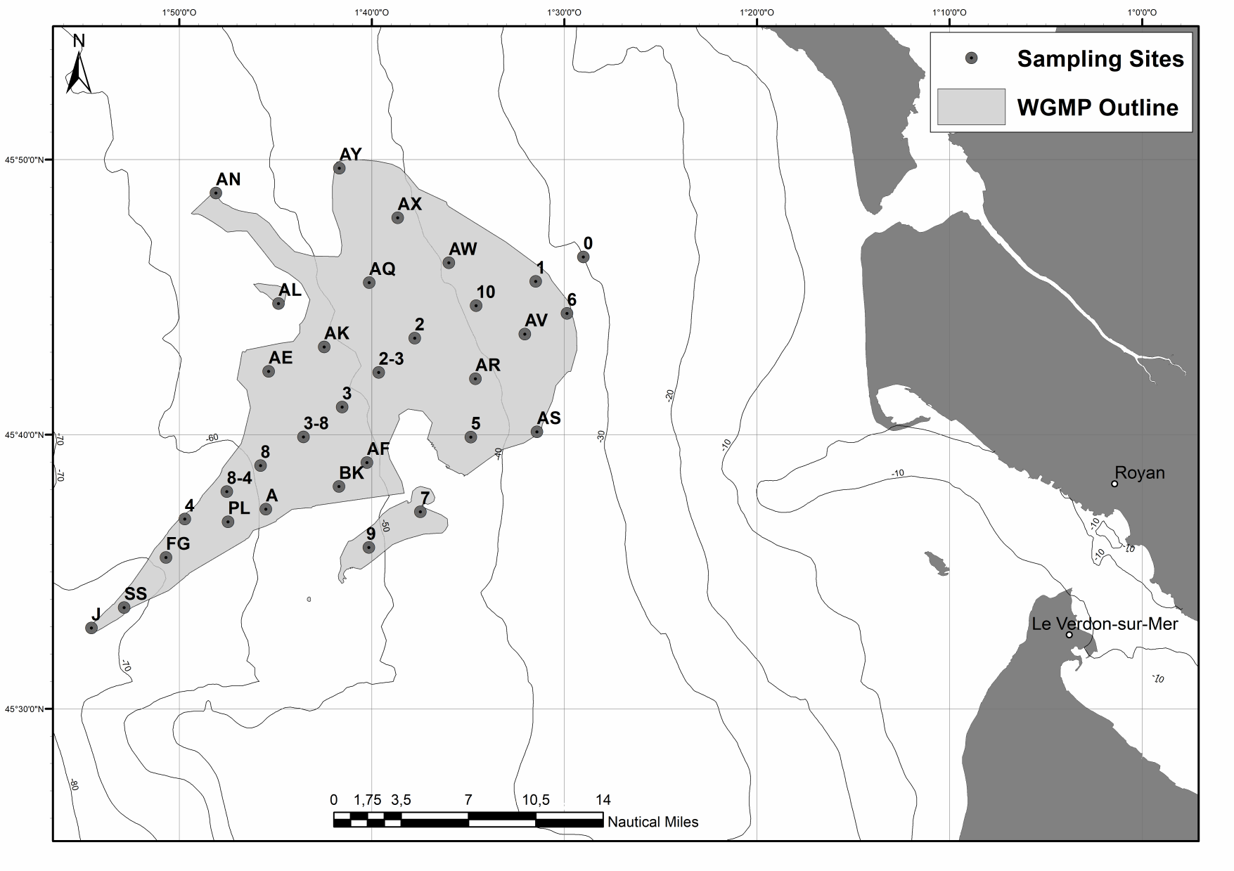
The spatial distributions of (1) surface sediment characteristics (D0.5, Sediment Surface Area (SSA), Particulate Organic Carbon (POC), Chlorophyll-a (Chl-a), Phaeophytin-a (Phaeo-a), Total and Enzymatically Hydrolyzable Amino Acids (THAA, EHAA), δ13C) and (2) sediment profile image (apparent Redox Potential Discontinuity (aRPD), numbers and depths of biological traces) characteristics were quantified based on the sampling of 32 stations located within the West Gironde Mud Patch (Bay of Biscay, NE Atlantic) in view of (1) assessing the spatial structuration of a temperate river-dominated ocean margin located in a high-energy area, (2) disentangling the impacts of hydrodynamics and bottom trawling on this structuration, and (3) comparing the West Gironde Mud Patch with the Rhône River Prodelta (located in a low-energy area). Results support the subdivision of the West Gironde Mud Patch in a proximal and a distal part and show (1) the existence of depth gradients in surface sedimentary organics characteristics and bioturbation within the distal part; (2) no evidence for a significant effect of bottom trawling, as opposed to Bottom Shear Stress, on the West Gironde Mud Patch spatial structuration; and (3) major discrepancies between spatial structuration in the West Gironde Mud Patch and the Rhône River Prodelta, which were attributed to differences in tidal regimes, sedimentation processes, and local hydrodynamics, which is in agreement with current river-dominated ocean margin typologies.
-
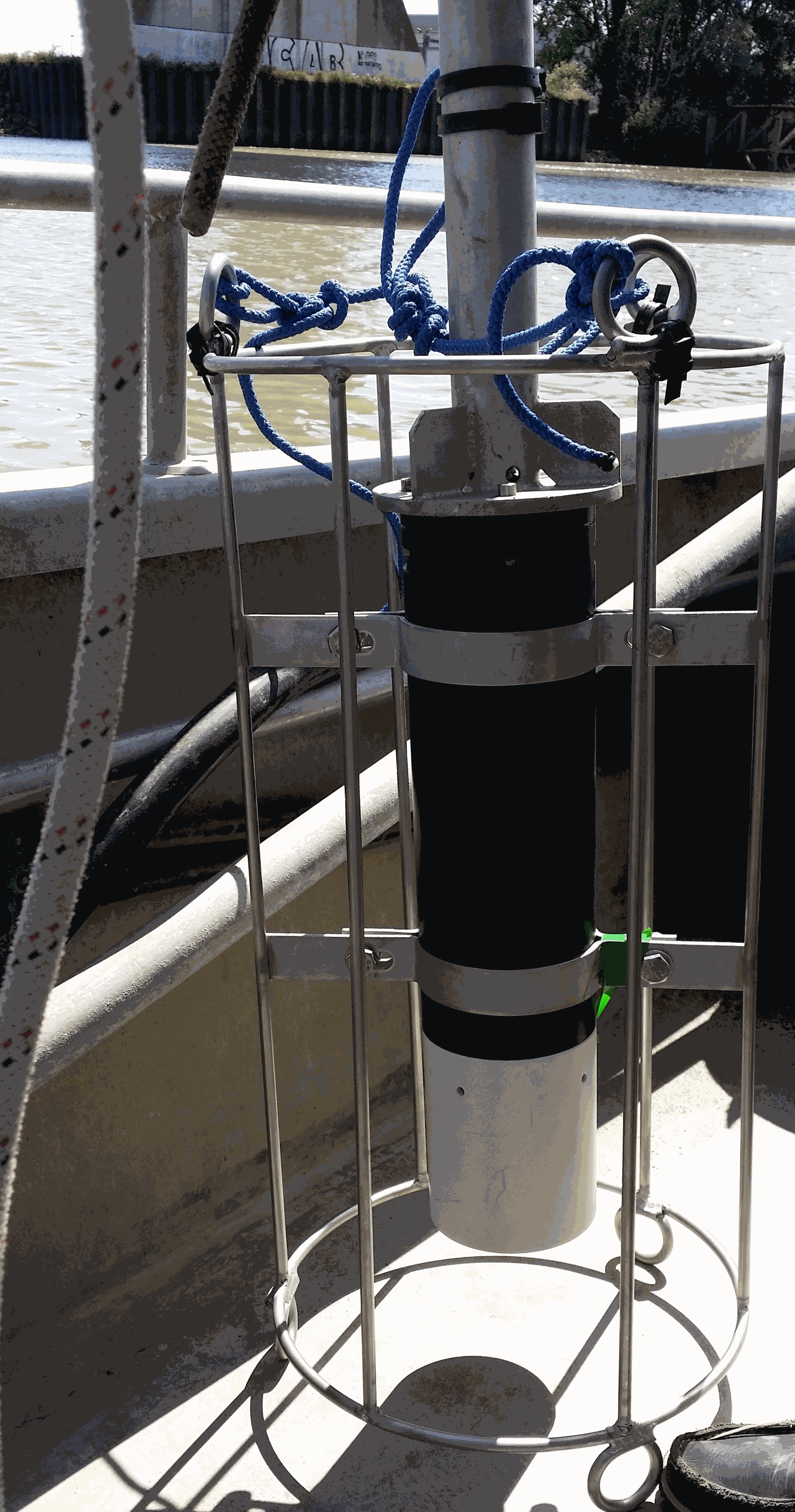
Key physico-chemical parameters (salinity, temperature, turbidity and dissolved oxygen) were measured in surface water during longitudinal transects in the Loire and Gironde estuaries in summers 2017 and 2018. This objective of this work was to determine the distribution of the dissolved oxygen and to detect potential severe desoxygenation. The transects were scheduled in order to begin the measurements at high tide from a site located upstream of an area where severe deoxygenation have been already been reported. Then, the transect was realised by sailing at low speed downstream with a multiparameter probe SAMBAT, maintained at 0.5 m below the surface, that collected a measurement every 2 minutes.