 Catalogue PIGMA
shp
Type of resources
Available actions
Topics
Provided by
Years
Formats
Representation types
Update frequencies
status
Scale
-

Aquitaine : zones de 1er appel
-
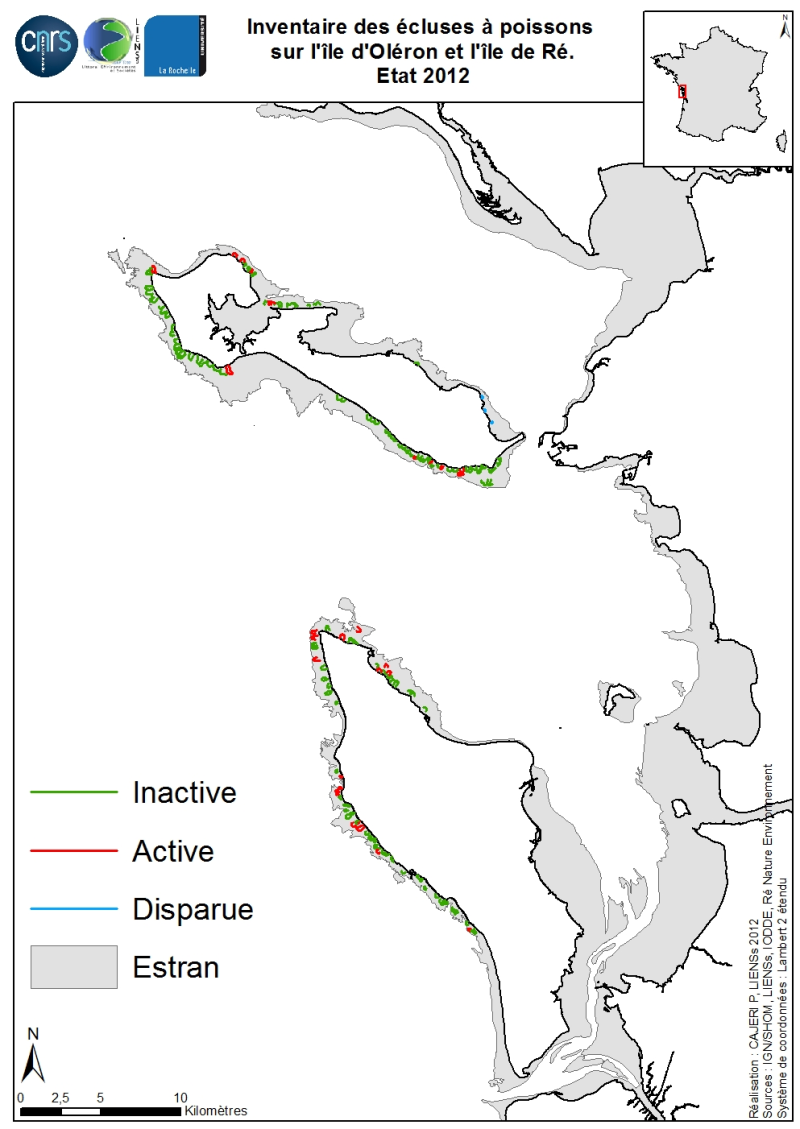
Un inventaire exhaustif des écluses à poissons a été réalisé pour les estrans des îles de Ré et d’Oléron en 2012. La méthode utilisée est la digitalisation sous SIG de supports géographiques comme les SCAN-25 de l’IGN. Cet inventaire a été par la suite validé par des reconnaissances de terrain par l’association IODDE (J. Pigeot) pour les écluses oléronaises et par Ré-Nature-Environnement (P. Le Gall) pour les écluses rhétaises. Ainsi les écluses toujours en activité ont pu être différenciées des écluses non actives et disparues. Au début du XVIII ème siècle, l’île de Ré comptait 114 écluses ; aujourd’hui, seules 15 sont toujours en activité. De même, pour l’île d’Oléron : 117 écluses étaient comptabilisées au XVIII ème siècle pour seulement 17 en activité aujourd’hui.
-
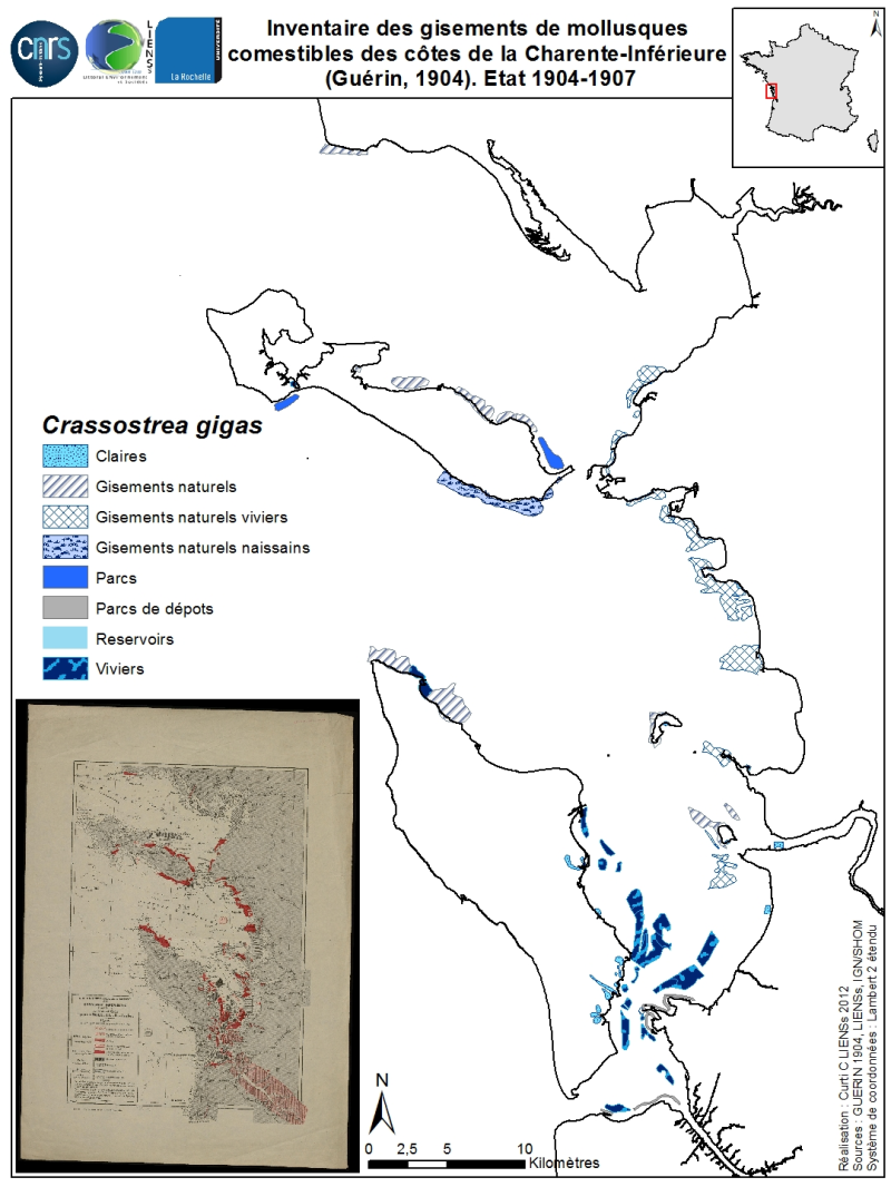
La distribution géographique des principaux gisements de mollusques comestibles des côtes de la Charente-Inférieure et du sud Vendée a été dressée en 1904 et 1907 par J. Guérin nommé aussi Guérin-Ganivet, préparateur au Muséum d’Histoire naturelles de Paris. L’iconographie est présentée sous forme de cartes dressées par A. Vaset (Guérin, 1904 ; Guérin-Ganivet, 1907). La carte de 1904 préalablement numérisée sur un support présent à la Médiathèque de La Rochelle a été digitalisée gisements par gisements afin d’extraire l’information spécifique. L’inventaire porte sur les gisements naturels et les structures d’élevage sur estrans (viviers, parcs, bouchots) ou à terre (claires) pour les espèces comestibles de l’époque. Sont répertoriées les gisements naturels disparus ou actifs, les viviers et claires d’engraissement et de verdissage de l’huître plate indigène Ostrea edulis Linné, 1758, les gisements naturels anciens ou récents, les viviers et claires pour l’huître introduite portugaise Crassostrea angulata Lamarck reconnue aujourd’hui comme étant similaire à l’huître creuse japonaise Crassostrea gigas (Thunberg, 1793) ; les moulières naturelles et bouchots à Mytilus edulis Linné, 1758 ainsi que les principaux gisements naturels du pétoncle Mimachlamys varia (Linné, 1758), de la palourde européenne Venerupis decussata (Linné, 1758), de la coque commune Cerastoderma edule (Linné, 1758) et de deux espèces de couteaux Ensis ensis (Linné, 1758) et Solen marginatus Pulteney, 1799. La reprise des informations des deux textes publiés (Guérin, 1904 ; Guérin-Ganivet, 1907) apporte des compléments sur la localisation de gisements naturels d’anomie Anomia ephippium Linné, 1758, de la lutraire Lutraria oblonga (Gmelin, 1791) et de la coquille St-Jacques Pecten maximus (Linné, 1758).
-
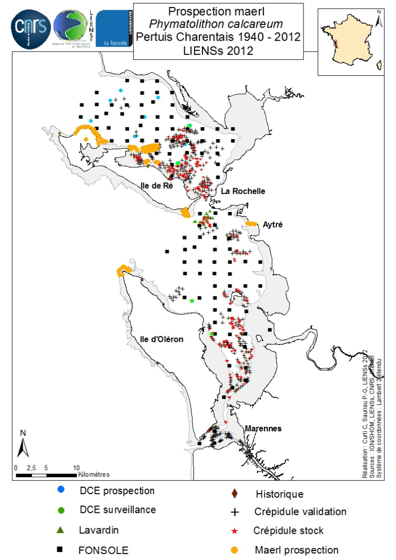
An inventory of mäerl ( unfixed red marine algae Corallinaceae with calcified arbuscular thalli) is taken in the Pertuis Charentais using the compilation of historical data and new observations over the period 2006-2012. The geographic extent of the inventory includes Pertuis Breton, Antioch and Maumusson, extends from the Lay estuary in the north to the Bay of Marennes-Oléron in the south and includes the edges of the islands of Ré, Oléron and Aix. Contributing to this inventory are, surveys DCE 2006 DCE, control monitoring DCE 2007 to 2012 under the aegis of Ifremer and Agences de l’Eau Loire-Bretagne and Adour-Garonne, surveys conducted for the Port Atlantique La Rochelle on the site of dredge spoil deposits in Lavardin from 2007 to 2012, surveys in 2007 FONSOLE by Ifremer and the surveys by Ifremer and laboratory LIENSs to map the crepidula stocks in the Pertuis Charentais Sea. Adding specific surveys conducted in 2011 by the ship Estran by dredge on subtidal bottom sediments of Pertuis Breton and intertidal quadrat in 2012 on the periphery of the islands of Ré, Oléron and along the cliffs of Aytré. The positioning of ground truthing stations were identified by GPS or dGPS. Initially identified by samples of the dredged material in October 2009 during the validation of sonar surveys to individualize stocks of crepidula, a live maerl bed is mapped in July 2011 in the harbor of Saint-Martin in Pertuis Breton. Its area is estimated at more than 2 km². Surveys of pedibus jambi conducted at the point of Grouin and Saint-Martin de Ré has confirmed the presence of live maerl scattered on the lower foreshore. This suggests a scattering of live maerl thalli of several tens of km² around the main bed of Saint-Martin. It is also confirmed by the single algological extraction of Phymatolithon calcareum done at the beginning of the twentieth century in Saint-Martin de Ré by Dollfus, probably already on the lower foreshore as observed in 2012 near the Couronneau beacon. Numerous dead maerl thalli in the procress of diagenesis have also been observed in the East and Southeast of Pertuis Breton and Antioch suggesting passive transport by contributions from live beds farther to the West, including Pertuis in Antioch. The presence of live maerl on the lower foreshore is seen very occasionally in the western islands of Oléron (Pointe Chassiron) and Ré (Phare des Baleines) via recent algologiques and fauna surveys. In biogeographic terms, the maerl bed of Pertuis Breton is the easternmost and southernmost of those known in the Bay of Biscay. The nearest mäerl beds known are respectively located in Noirmoutier (Bourgneuf Bay) and Galicia (Spain). These observations complement the atlas mapping of maerl populations in Europe published under the auspices of the OSPAR Convention. They provide a knowledge base for future conservation actions defined locally in the context of Natura 2000 Sea Marine Natural Park of the Gironde estuary and the Pertuis Charentais.
-

Impacts de foudre air-sol du 01/01/2014 au 31/12/2014. Ces données sont issues d'un export depuis l'application Météorage permettant d'afficher et d'analyser les événements foudre en temps réel (impacts air-air et air sol). Pour cet export seul les impacts air/sol ont été retenus.
-
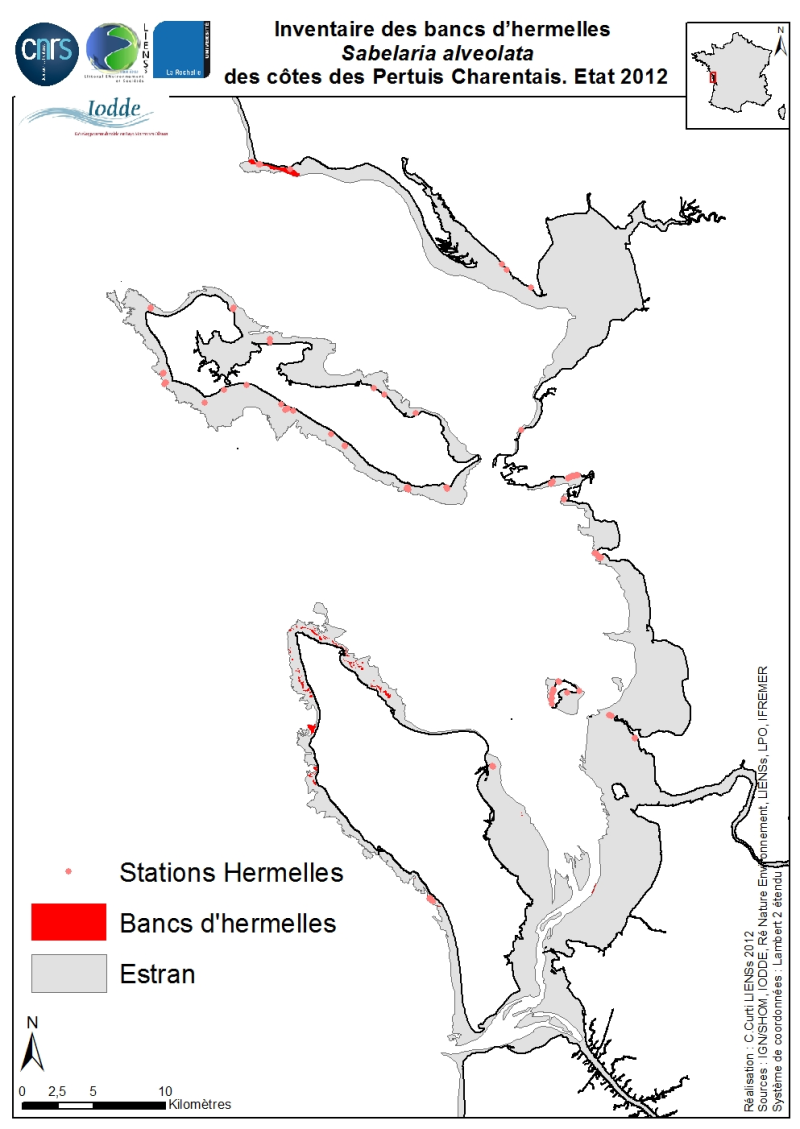
The geographical distribution of the main Sabellaria Hermelles alveolata beds (Linné, 1767) from the coast of the Pertuis Charentais was compiled from 2010 to 2012. The inventory focuses on the tidal beds (+ 6-0 m marine coast) and compiles two cartographic sources from the project CARTHAM Natura 2000 at sea of the Agency of Marine Protected Areas: 1) Hermelles inventories made on 2011 by the Association IODDE on the west of Oleron Island and 2) mapping inventory of intertidal marine habitats by LIENSs (in cooperation with CREOCEAN, Ré Nature Environnement, GEO-Transfert et la LPO Moëze-Oléron). Methodologies used by IODDE on Oléron combine ground truths with reports with Geographic Information System (GIS). The methodologies used by LIENSs to estimate the extension of the intertidal habitats throughout the Pertuis Charentais combine aerial image analysis, remote sensing, field validations by differential GPS and thematic analysis using GIS (Cajeri et al., 2012). It is during these ground truths that the presence of tackles or small Hermelles reefs was noted. The IODDE results have allowed an almost exhaustive inventory of Hermelles reefs west of Oleron. Those of LIENSs have clarified the distribution of Hermelles on most of the Pertuis Charentais foreshores.
-
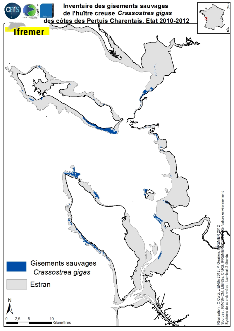
The geographical distribution of the main sources of wild Pacific oysters (Crassostrea gigas) (Thunberg, 1793) on the coasts of the Pertuis Charentais was compiled from 2010 to 2012. The inventory focuses on natural foreshore deposits (+ 6-0 m sea coast) and compiles two cartographic sources: 1) quantitative inventories made in 2010 by Ifremer from the Tranche sur Mer (Vendée) to Vaux-sur-Mer in 21 representative sites to estimate wild stocks of Pacific oysters and 2) inventory mapping of intertidal marine habitats mainly made by LIENSs (in cooperation with CREOCEAN, IODDE, Ré Nature Environnement and GEO-Transfert) under the project CARTHAM Natura 2000at sea of the Agency of Marine Protected Areas. Methodologies used by Ifremer to estimate the areas colonized combine thematic analysis in Geographic Information System (GIS) and field validations (Soletchnik et al., 2012). The methodologies used to estimate LIENSs extension of the intertidal habitat of the oysters combined aerial image analysis, remote sensing, field validations and thematic analysis using GIS (Cajeri et al., 2012).
-

Dordogne : Plan Local d'Urbanisme (PLU) Le plan local d'urbanisme (PLU) est le principal document d'urbanisme de planification de l'urbanisme au niveau communal ou éventuellement intercommunal. Il remplace le plan d'occupation des sols (POS) depuis la loi relative à la solidarité et au renouvellement urbains du 13 décembre 2000, dite loi SRU[
-

Aquitaine : tours de guet
-
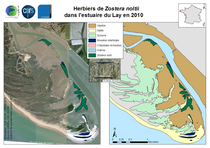
La répartition de l’herbier de Zostera noltii Hornemann, 1832 sur les estrans de la pointe d’Arcay côté estuaire du Lay a été cartographiée les 8 et 26 novembre 2010 à partir de relevés à marée basse fait par dGPS Trimble (GéoExplorer GeoXT 2005) de précision submétrique. Cette carte est présentée dans la synthèse réalisée par Auby et al. (2010a, b) dans le volume des annexes (p. 141-145) à propos de la répartition des angiospermes des côtes françaises Manche-Atlantique dans les masses d’eau suivies dans le cadre de la DCE. L’herbier se présente sous la forme de quatre grandes entités disjointes réparties le long des estrans, rive droite, du chenal du Lay. Chaque entité est située à proximité d’un ancien crochon dunaire dont la succession depuis deux siècles caractérise la progression vers le Sud-Est de la pointe d’Arcay. De petites tâches éparses d’herbier sont notées dès le premier crochon dunaire jusqu’à l’îlot vaseux situé au centre du chenal au droit du lieu dit Les Caves. L’herbier est apparu dense à très dense. La présence de moulières intertidales à Mytilus edulis sur vase et de bancs de crépidules Crepidula fornicata en chaînes éparses drossées à la côte a été notée. Ni Zostera marina ni sa forme naine Zostera marina angustifolia n’ont été observées en 2010 sur le site et leur présence est jugée improbable. Cette cartographie sur estran des herbiers vient compléter les cartographies de végétation terrestre disponibles pour la Réserve de chasse et de faune sauvage de la pointe d’Arcay.