/Human Activities
Type of resources
Available actions
Topics
Keywords
Contact for the resource
Provided by
Years
Formats
Representation types
Resolution
-

The Human Activities portal was not included in the first phase of EMODnet, and its development only begun in September 2013. Nonetheless, in the previous EMODnet phase, the Human Activities team caught up with the other portals, and now work towards providing a seamless multi-resolution digital map of European waters, with the highest resolution possible. EMODnet Human Activities aims to facilitate access to existing marine data on activities carried out in EU waters, by building a single entry point for geographic information on 14 different themes. The portal makes available information such as geographical position, spatial extent of a series of activities related to the sea, their temporal variation, time when data was provided, and attributes to indicate the intensity of each activity. The data are aggregated and presented so as to preserve personal privacy and commercially-sensitive information. The data also include a time interval so that historic as well as current activities can be included. The information provided through the portal is collated from a variety of sources, harmonised and made interoperable. Data are free and free of any restrictions, in such a way as to ensure their use from a multitude of stakeholders (policy makers, researchers, students, spatial planners, etc.).
-

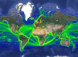
This data was obtained through a partnership with IMF, as part of IMF's World Seaborne Trade Monitoring System (Cerdeiro, Komaromi, Liu and Saeed, 2020). The data analysis was supported by the World Bank’s ESMAP and PROBLUE programs. The dataset contains 6 density layers, with vessel types aggregated to suit the needs of the WBG Offshore Wind Development Program: 1) Commercial ships 2) Fishing ships 3) Oil & Gas [note: this is just platforms, rigs, and FPSOs] 4) Passenger ships 5) Leisure vessels 6) GLOBAL ship density layers of all ship categories combined
 Catalogue PIGMA