 Catalogue PIGMA
Land cover
Type of resources
Available actions
Topics
Keywords
Contact for the resource
Provided by
Years
Formats
Representation types
Update frequencies
status
Scale
Resolution
-

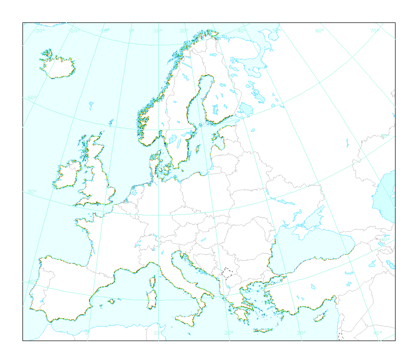
The EMODnet Bathymetry World Coastline is available as a WFS service from EMODnet Bathymetry. The service URL is: https://ows.emodnet-bathymetry.eu/wfs. The layer contains vector lines derived from land polygons available from OpenStreetMap. The original source url is https://osmdata.openstreetmap.de/. Parts of these polygons have been modified for use in EMODnet Bathymetry. In addition to the OSM EMODnet default coastline, three sub-layers are available as part of the EMODnet world coastline service. These sub-layers contain the best-estimate coastlines for Europe determined by Dutch research institute Deltares from satellite data (typically Sentinel-2 and Landsat-8) and in combination with the Global Tide Surge Model (GTSM) processed into digital coastlines for the European seas at LAT (Lowest Astronomical Tide), MSL (Mean-Sea-Level), and MHW (Mean-High-Water). The level of detail is bound to the resolution of the satellite sensor (e.g. 10m for Sentinel-2). The latest December 2020 version now covers the entire coastline of Europe. A detailed paper is available describing the methodology used to determine the three versions of the satellite derived coastline: https://emodnet.ec.europa.eu/sites/emodnet.ec.europa.eu/files/public/20201219_emodnet_bathymetry_satellite_derived_coastline_report.pdf
-
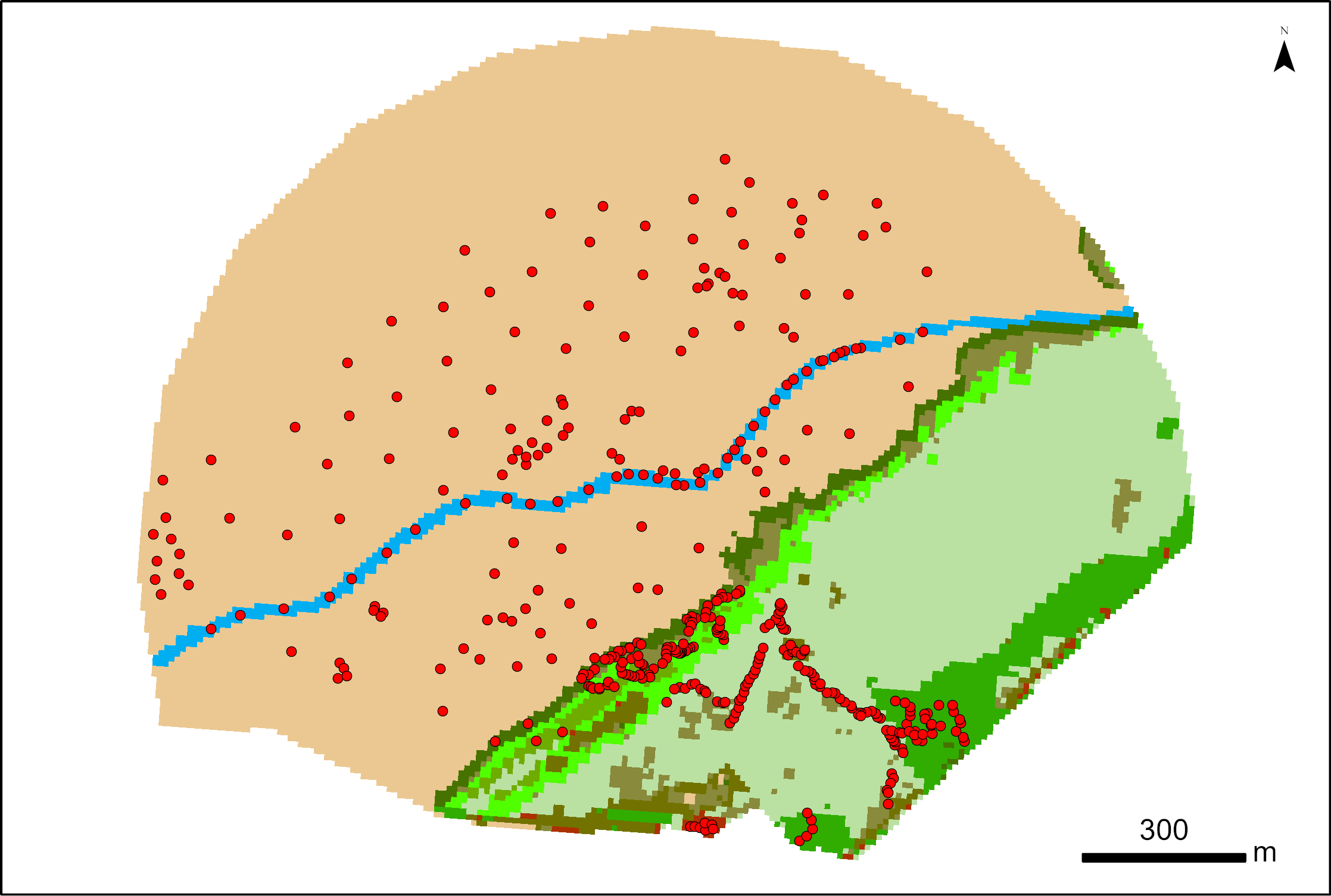
387 points were surveyed with a SP80 DGPS by Maxime Paschal as part of the La Rochelle Zero Carbon Territory (LRTZC) project on 26/05/23. At each point, the type of vegetation was specified.
-
LaCoast is a research project undertaken in the mid 1990 under the lead of the Joint Research Centre (JRC) and aimed at quantifying the changes of land cover types in a 10 km land strip from the coastline. LaCoast uses CORINE Land Cover version 1990 as its reference dataset and track differences of land cover changes using LANDSAT satellite images from the mid-1970's.
-

The dataset on Natura 2000 sites was created in 2014 by Cogea for the European Marine Observation and Data Network. It is entirely based on spatial data from the European Environmental Agency (EEA), plus additional info, links and selected EEA data joined to the feature attributes, as well as a calculation by Cogea of marine and coastal location of features. It is available for viewing and download on EMODnet - Human Activities web portal (www.emodnet-humanactivities.eu). Natura 2000 is an ecological network composed of sites designated under the Birds Directive (Special Protection Areas, SPAs) and the Habitats Directive (Sites of Community Importance, SCIs, and Special Areas of Conservation, SACs). The dataset covers the whole EU. Following the United Kingdom’s withdrawal from the EU on 31 January 2020, it ceased to be part of the EEA’s institutional networks and governance. In the webmap the EEA dataset has been filtered by Cogea to show only (i) marine sites, i.e. sites with a marine area percentage higher than 0 (as calculated by the EEA) and (ii) sites that, even if not identified as marine by the EEA, intersect the EEA coastline or that are within a distance of 1 km from the coastline (using a 1 km inner buffer from the EEA coastline). In both cases the COAST_MAR field value=1. The EEA coastline dataset is available at https://www.eea.europa.eu/data-and-maps/data/eea-coastline-for-analysis-2. Compared with the previous version, this one includes the updated dataset 'Natura 2000 End 2020', published by the EEA in July 2021. For further information (e.g. biogeographic region, directive, habitats, sites, impact, management, species and metadata) please visit the EEA's website hosting the Natura 2000 tabular data.
-

Cartographie de l'Aide du département des Pyrénées Atlantiques à l'installation des Jeunes Agriculteurs (AJA)
-

Cartographie des établissements publics ayant choisi d'adhérer à la charte Manger Bio&Local, Labels et Terroir. Cartographie réalisée par géocodage avec le batch géocodeur en ligne et reprise des éléments non géocodés de manière manuelle (Google maps et pages blanches/jaunes)
-
Cartographie des zones de haute montagne, montagne, piémont et défavorisées
-
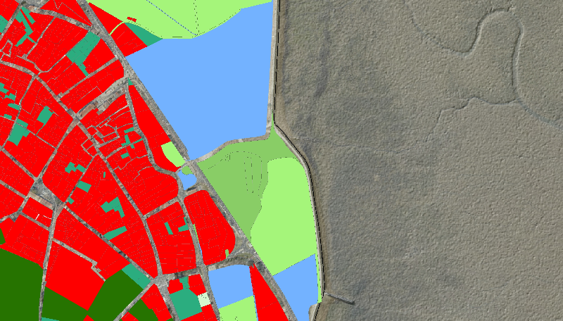
Description à la parcelle de l’occupation du sol en 2013, pour les 4 communes d'étude de l'île d'Oléron du programme de recherche RISKS : Saint-Pierre-d'Oléron, Le Château-d'Oléron, Saint-Georges-d'Oléron et Saint-Trojan-les-Bains.
-
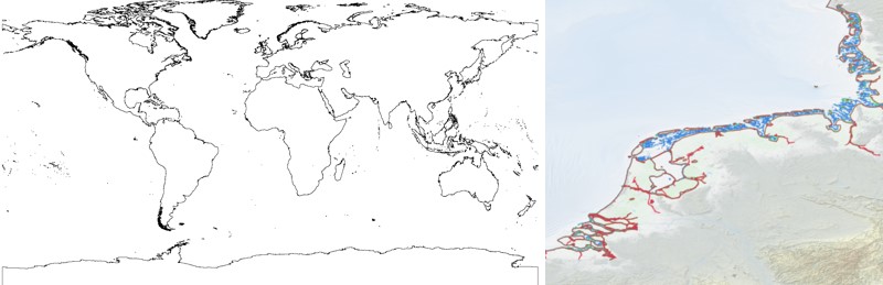
The EMODnet Bathymetry World Coastline is available as a WFS service from EMODnet Bathymetry. The service URL is: https://ows.emodnet-bathymetry.eu/wfs. The layer contains vector lines derived from land polygons available from OpenStreetMap. The original source url is https://osmdata.openstreetmap.de/. Parts of these polygons have been modified for use in EMODnet Bathymetry. In addition to the OSM EMODnet default coastline, three sub-layers are available as part of the EMODnet world coastline service. These sub-layers contain the best-estimate coastlines for Europe determined by Dutch research institute Deltares from satellite data (typically Sentinel-2 and Landsat-8) and in combination with the Global Tide Surge Model (GTSM) processed into digital coastlines for the European seas at LAT (Lowest Astronomical Tide), MSL (Mean-Sea-Level), and MHW (Mean-High-Water). The level of detail is bound to the resolution of the satellite sensor (e.g. 10m for Sentinel-2). The latest 2024 version covers the entire coastline of Europe and now also part of the Caribbean. A detailed paper is available describing the methodology used to determine the three versions of the satellite derived coastline: https://emodnet.ec.europa.eu/sites/emodnet.ec.europa.eu/files/public/EMODnet_Bathymetry_2024-satellite_derived_coastline_report_Deltares_Feb2025.pdf
-
This dataset is the coastal zone land surface region from Europe, derived from the coastline towards inland, as a series of 10 consecutive buffers of 1km width each. The coastline is defined by the extent of the Corine Land Cover 2018 (raster 100m) version 20 accounting layer. In this version all Corine Land Cover pixels with a value of 523, corresponding to sea and oceans, were considered as non-land surface and thus were excluded from the buffer zone.