 Catalogue PIGMA
Waves
Type of resources
Available actions
Topics
Keywords
Contact for the resource
Provided by
Years
Formats
Representation types
Update frequencies
status
Scale
Resolution
-
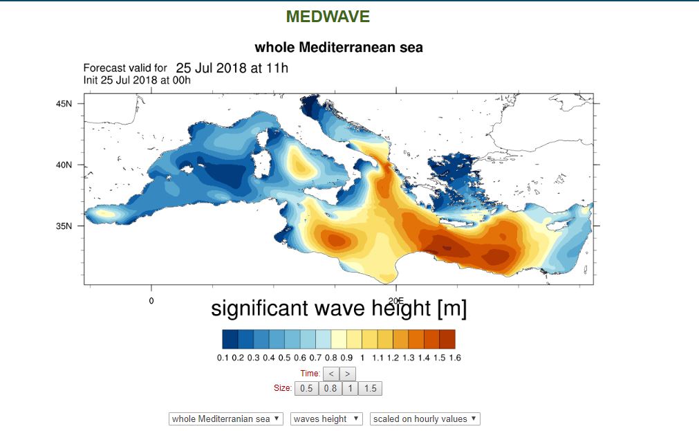
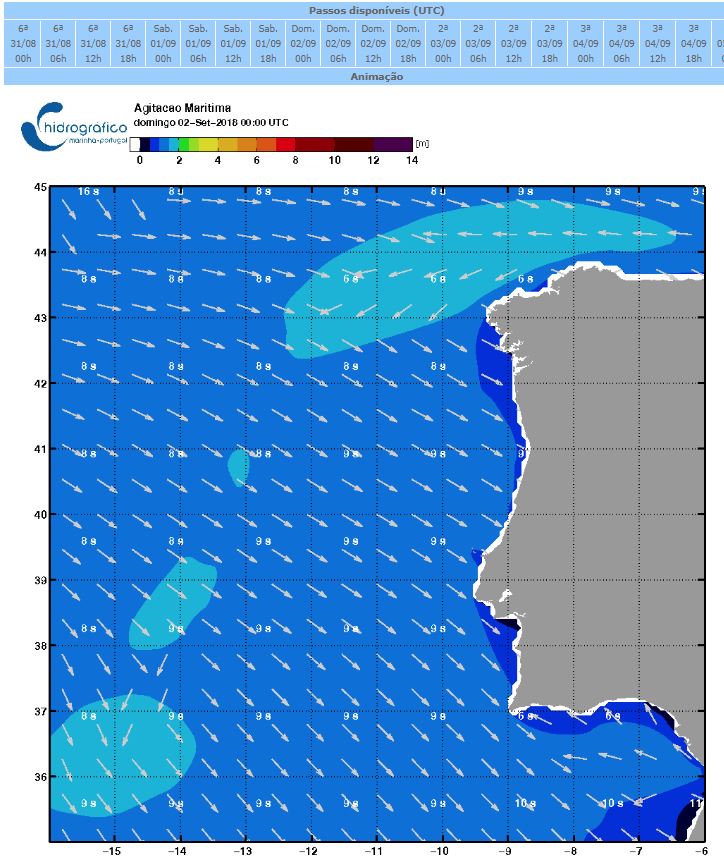
Web portal providing wave energy forecast at the spatial resolution of 1/32°. Higher resolution forecasts (1/128°) are computed over ten sub-basins around the Italian coasts.
-
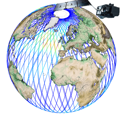
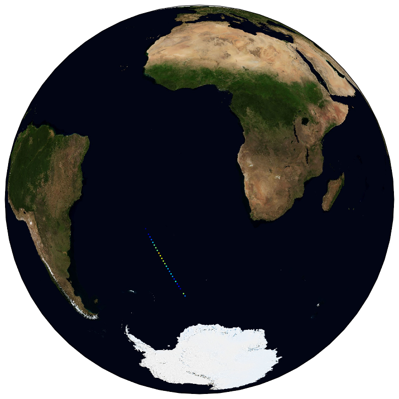
Along-track significant wave height (SWH) and wind speed modulus for the following missions : CFOSAT (nadir), Sentinel-3A, Sentinel-3B, Jason-3, Saral-AltiKa, Cryosat-2 and HY-2B in Near-Real Time (NRT) for a global coverage (-66°S/66+N for Jason-3, -80°S/80°N for Sentinel-3A and Saral/AltiKa). SWH measurements are computed from the leading edge of the altimeter waveform. For Sentinel-3A and 3B, they are deduced from the SAR altimeter. One file containing valid SWH is produced for each mission and for a 3-hour time window. It contains the filtered SWH (VAVH), the unfiltered SWH (VAVH_UNFILTERED) and the wind speed (wind_speed).
-
During the SARDINIA experiment, three coincident MCS reflection and wide-angle seismic profiles, sub-bottom high resolution (CHIRP) profiles, and bathymetry data were collected on the Gulf of Lion margin. The seismic reflection data were acquired using a 4.5 km, 360 trace digital streamer and a tuned airgun array of 8260 in3, towed at a depth of 18-28 m. A total of 57 ocean bottom seismometer/ hydrophones (OBS/OBH) from Ifremer, University of Brest, and Geomar Kiel were deployed in the Gulf of Lion, spaced every 7 Nm (~13 km). The airgun array consists of 16 airguns ranging from 100 in3 G-guns to 16 L Bolt airguns, with main frequencies centered around 10-15 Hz. The airguns were tuned to the first bubble to enhance low frequencies and ensure a good penetration. The shot interval was 60 s at an average speed of 5 knots, which translates to a trace spacing of about 140-150 m. The sample rate was 8 ms for the micrOBS, 5 ms for the Geomar’s OBS and 4 ms for the OldOBS. A total of 6160 shots (profile AB: 3032, profile CD: 1730, profile EF: 1398) were fired by the air gun array. Profile AB crosses the Gulf of Lion’s margin, parallel to the ECORS profile, from the continental shelf to Domain III. Twenty-five ocean bottom seismometers (OBS) were deployed on this profile, of 467 km in length. Twenty-two instruments were used in the wide-angle modelling, since three instruments (OBS 45, 49 and 52) did not properly record. The shots on this profile were additionally recorded by 9 land seismic stations (OSIRIS stations from the University of Brest and Geosciences Azur) that have extended the marine profile ~120 km onshore. Profiles CD and EF are 250 and 210 km long transects parallel to the margin. Profile CD was acquired using 19 OBS of which 18 yielded usable data. Profile EF was acquired using 15 OBS of which 12 yielded usable data. These two profiles cross the profile AB, respectivelyat OBS 26 and OBS 8.
-
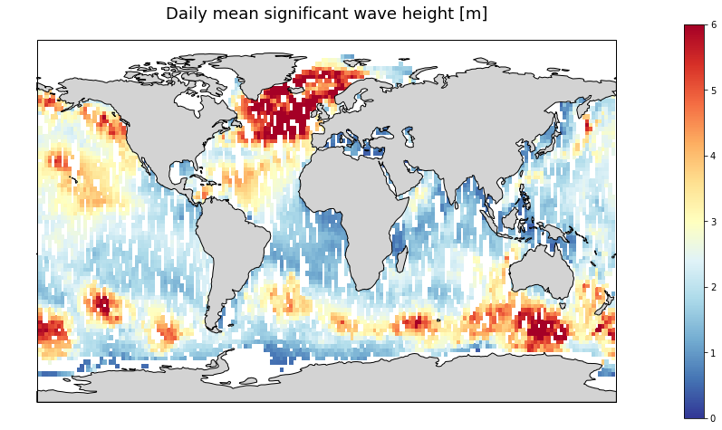
Gridded multi-mission merged satellite significant wave height in Near-Real-Time. It merges along-track SWH data from the following missions: Jason-3, Sentinel-3A, Sentinel-3B, SARAL/AltiKa, Cryosat-2 and CFOSAT.
-
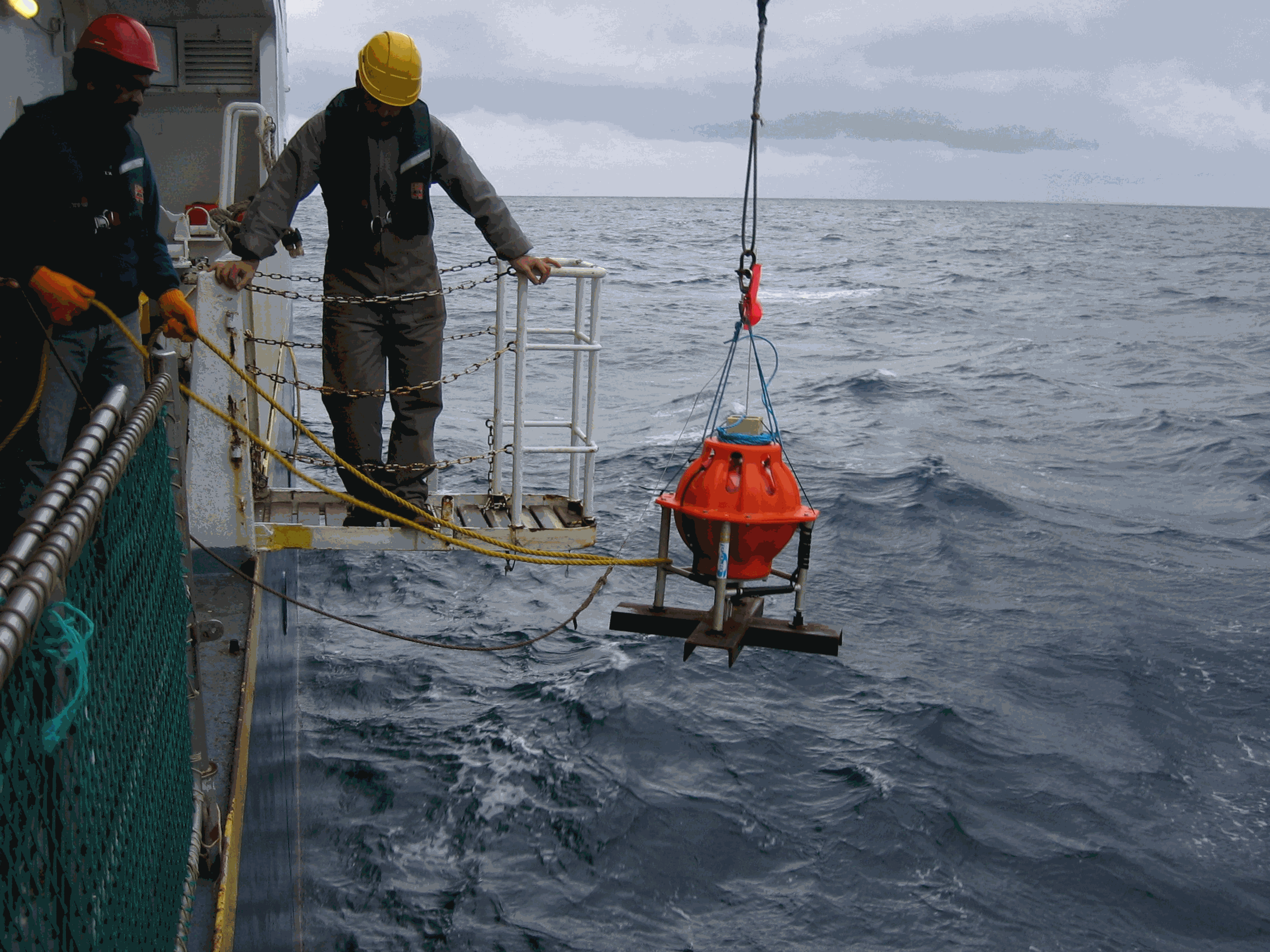
This product integrates observations aggregated and validated from the Regional EuroGOOS consortium (Arctic-ROOS, BOOS, NOOS, IBI-ROOS, MONGOOS and Black Sea GOOS) as well as from National Data Centers (NODCs) and JCOMM global systems (Argo, GOSUD, OceanSITES, GTSPP, DBCP) and the Global telecommunication system (GTS) used by the Met Offices. Data are available in a dedicated directory to waves (INSITU_GLO_WAV_REP_OBSERVATIONS_013_045) of GLOBAL Distribution Unit in one file per platform. This directory is updated twice a year. Data are distributed in two datasets, one with original time sampling and the other with hourly data and rounded timestamps. The information distributed includes wave parameters and wave spectral information. The latest version of Copernicus delayed-mode wave product is distributed from Copernicus Marine catalogue. Additional credits: The American wave data are collected from US NDBC (National Data Buoy Center). The Australian wave data are collected from Integrated Marine Observing System (IMOS); IMOS is enabled by the National Collaborative Research Infrastructure Strategy (NCRIS); It is operated by a consortium of institutions as an unincorporated joint venture, with the University of Tasmania as Lead Agent. The Canadian data are collected from Fisheries and Oceans Canada.
-
he Hydrographic Institute of Portugal collects and disseminates to a wide user community useful hydrographic/oceanographic information.
-
Significant Wave Height (SWH) monomission along-track altimeter satellite product available for Sentinel-3A, Sentinel-3B and Sentinel-6 Michael Freilich missions in Near-Real-Time. SWH values are computed from the High Resolution Mode, also known as Synthetic Aperture Radar mode (SAR) and are calibrated relative to buoys. A validity flag and the applied correction are also provided. Since April 2021, a new variable is included in the files : wind speed, computed by Gourrion (2002) algorithm using Collard (2005) table with PLRM sigma0 and SWH. Moreover, the values are cross-calibrated with Jason-3 standard F wind speed.
-
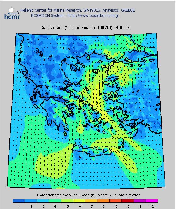
By establishing a network of observation buoys and the creation of a specialized operational center for the processing of the data collected and the production of forecasts, POSEIDON is an infrastructure at the leading edge of modern oceanography in Europe. The network of observation buoys records continuously the physical, biological and chemical parameters of the Greek seas. Those data are then transmitted to the operational center where they are sorted and fed into forecasting models.
-
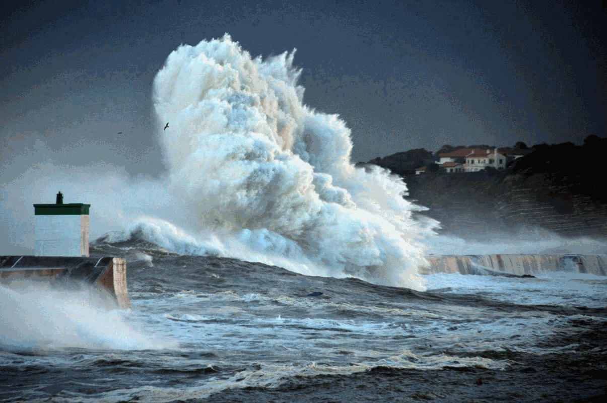
Wave impact is the primary cause of coastal structure failure. While wave impact is widely studied in controlled environments, in situ measurements of wave impact pressure are rare. The results of a campaign to measure wave impact pressure in situ are summarised here. Data were collected from 2016 to 2019 from anchored pressure gauges on the wall of the Artha breakwater in southwestern France. The acquisition frequency is 10 kHz and 10-minute bursts are recorded every hour. Two databases are published, one by burst and one by impact. The burst database summarises the main parameters describing the 10-minute record, while the impact database contains a list of parameters describing each impact.
-
The ESA Sea State Climate Change Initiative (CCI) project has produced global multi-sensor time-series of along-track satellite synthetic aperture radar (SAR) integrated sea state parameters (ISSP) data from ENVISAT (referred to as SAR Wave Mode onboard ENVISAT Level 2P (L2P) ISSP data) with a particular focus for use in climate studies. This dataset contains the ENVISAT Remote Sensing Integrated Sea State Parameter product (version 1.1), which forms part of the ESA Sea State CCI version 3.0 release. This product provides along-track significant wave height (SWH) measurements at 5km resolution every 100km, processed using the Li et al., 2020 empirical model, separated per satellite and pass, including all measurements with flags and uncertainty estimates. These are expert products with rich content and no data loss. The SAR Wave Mode data used in the Sea State CCI SAR WV onboard ENVISAT Level 2P (L2P) ISSP v3 dataset come from the ENVISAT satellite mission spanning from 2002 to 2012.