 Catalogue PIGMA
benthos
Type of resources
Available actions
Topics
Keywords
Contact for the resource
Provided by
Years
Formats
Representation types
Update frequencies
status
Scale
-
EMODnet Biology provides three keys services and products to users. 1)The data download toolbox allows users to explore available datasets searching by source, geographical area, and/or time period. Datasets can be narrowed down using a taxonomic criteria, whether by species group (e.g. benthos, fish, algae, pigments) or by both scientific and common name. 2) The data catalogue is the easiest way to access nearly 1000 datasets available through EMODnet Biology. Datasets can be filtered by multiple parameters via the advanced search from taxon, to institute, to geographic region. Each of the resulting datasets then links to a detailed fact sheet containing a link to original data provider, recommended citation, policy and other relevant information. Data Products - EMODnet Biology combines different data from datasets with overlapping geographic scope and produces dynamic maps of selected species abundance. The first products are already available and they focus on species whose data records are most complete and span for a longer term.
-
The European Ocean Biogeographic Information System - EurOBIS - is an online marine biogeographic database compiling data on all living marine creatures. The principle aims of EurOBIS are to centralize the largely scattered biogeographic data on marine species collected by European institutions and to make these data freely available and easily accessible. All data go through a number of quality control procedures before they are made available online, assuring a minimum level of quality necessary to put the data to good use. The available data are either collected within European marine waters or by European researchers and institutes outside Europe. The database focuses on taxonomy and distribution records in space and time; all data can be searched and visualised through a set of online mapping tools. All data are freely available online and easily accessible, without requiring a login or password.
-
données invertébrés et vertébrés benthiques des habitats d'intérêt communautaire récifs 1130 en 2008, acquises en plongées. transects sous-marins.
-

Dans le cadre de l'ANR Pampas, plusieurs stations ont été définies et identifiées. Ces stations regroupent l'ensemble des captures, des prélèvements, des carottages, des mesures et des enquêtes réalisées, pour chaque compartiment étudié : Arthropode; Benthos; Enquête Art Sciences; Enquêtes de perception; Enquête Patrimoine; Flux de Carbone; Hydrodynamisme; Oiseaux; Plancton; Poissons; Sédimentation et Carbone.
-

The International Council for the Exploration of the Sea (ICES), is a global organization that develops science and advice to support the sustainable use of the oceans. ICES is a network of more than 5,000 scientists from over 690 marine institutes in 20 member countries and beyond. 1,500 scientists participate in our activities annually. ICES has a well-established Data Centre, which manages a number of large dataset collections related to the marine environment. The majority of data – covering the Northeast Atlantic, Baltic Sea, Greenland Sea, and Norwegian Sea – originate from national institutes that are part of the ICES network. The ICES Data Centre provides marine data services to ICES member countries, expert groups, world data centres, regional seas conventions (HELCOM and OSPAR), the European Environment Agency (EEA), Eurostat, and various other European projects and biodiversity portals. ICES aims to provide all data collections online and according to the ICES Data policy, which enables open access to all data that are do not fall under specific commercial or personal privacy concerns.
-
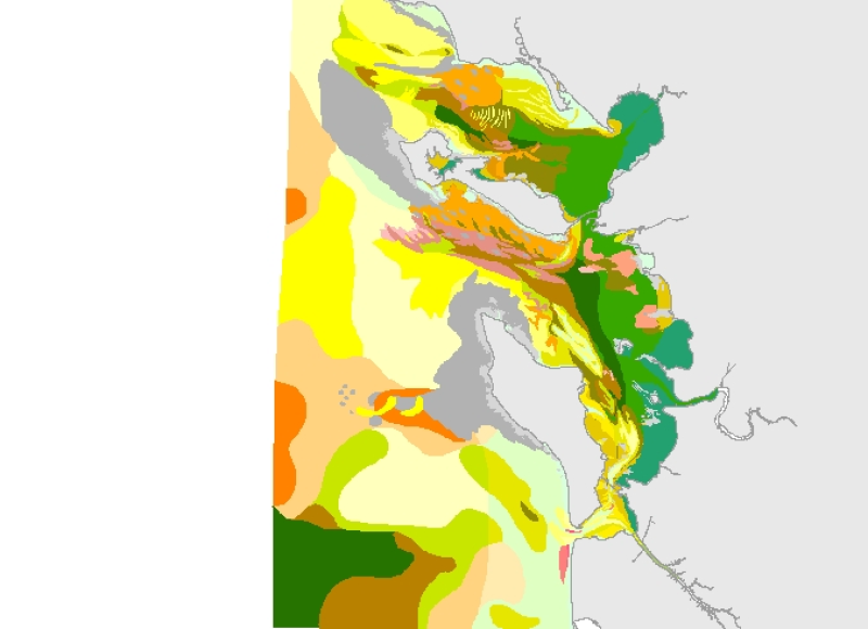
Cette carte est la synthèse de cartes extraites de la thèse de Christian Hily sur les "Pertuis Charentais" publiée en 1976 et de la carte de Claude Chassé intitulée "Pertuis et îles Charentais - Carte bio-sédimentaire (Prévision)" de 1974, (avec pour la partie ouest, l'intégration des travaux géomorphologiques de J.P. Barusseau, D. Dorel et M. Tesson et des travaux de biologie de F. Lagardère (vasière de Gironde)). Une harmonisation avec la typologie EUNIS a été réalisée en 2008, avec l’expertise de l’auteur (projets Rebent et Interreg-MESH).
-
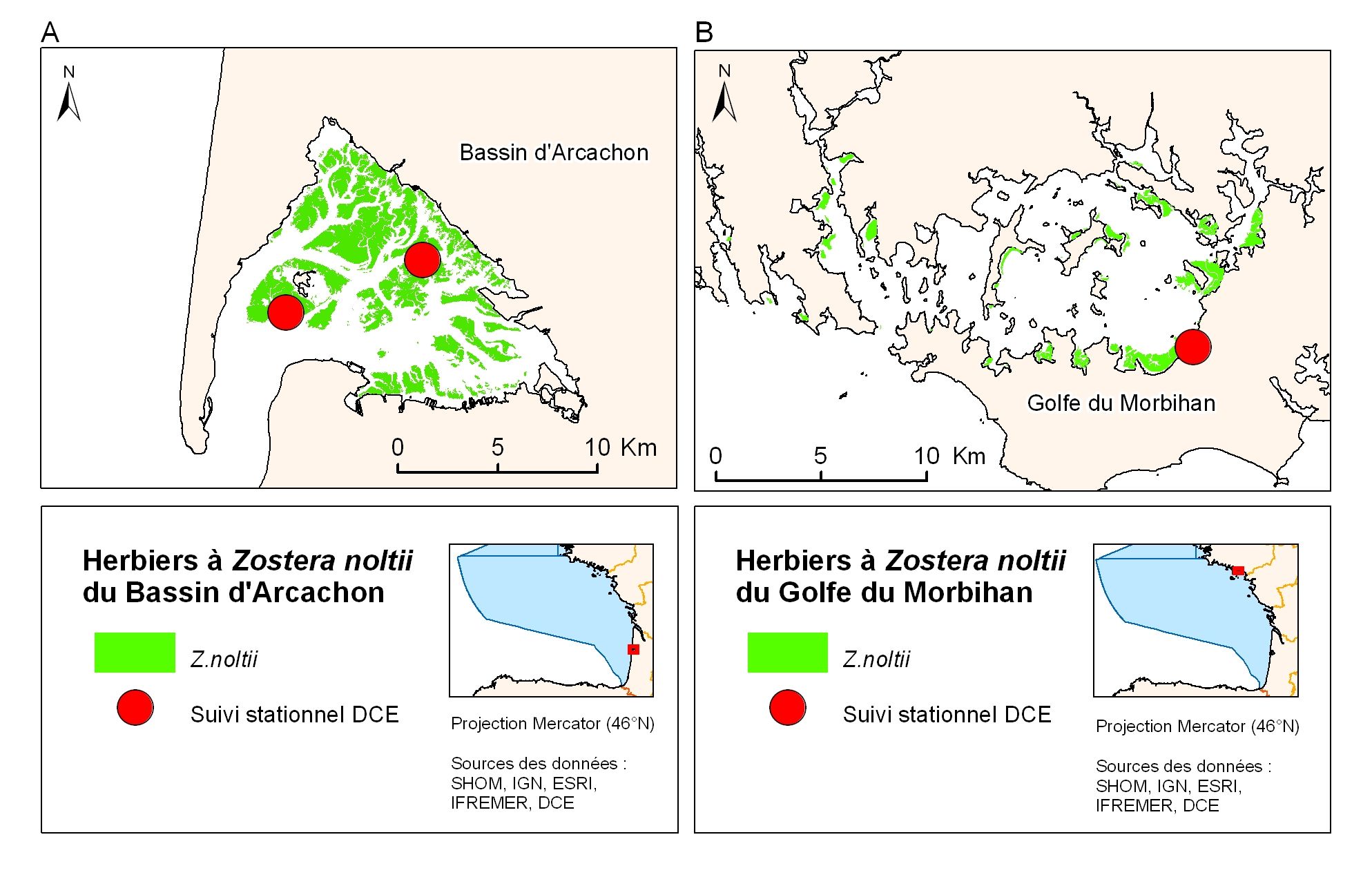
Cartographie des herbiers à Zostera noltii du Bassin d'Arcachon et du Golfe du Morbihan, sous-région Golfe de Gascogne
-
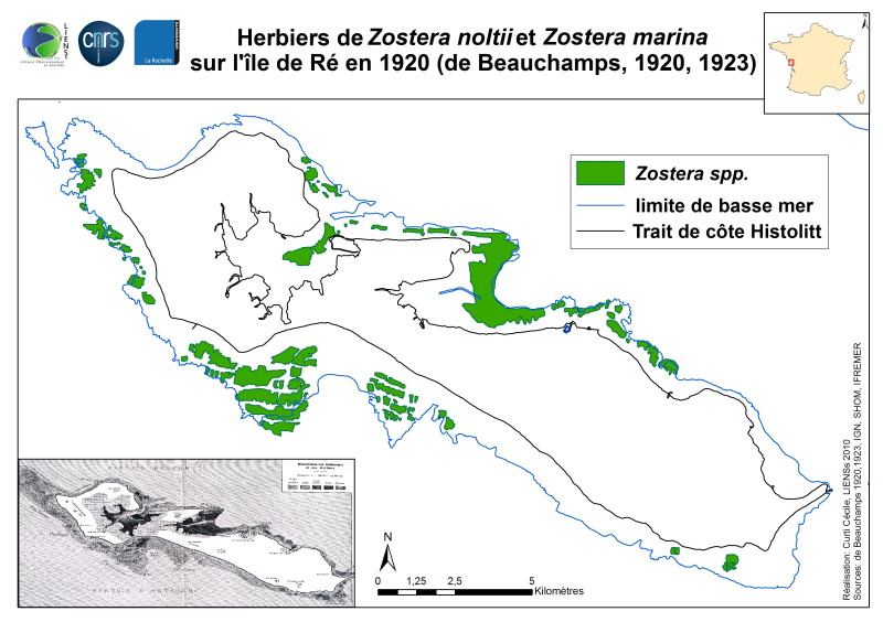
La distribution des herbiers à Zostera marina Linné, 1753 et Zostera noltii Hornemann, 1832 a été cartographiée en août-septembre 1920 par des observations terrain de bionomie et reports manuels sur carte au 1 : 93000 environ. Cette carte est issue de l’article par de Beauchamp (1923) « Etudes de bionomie intercotidale les Iles de Ré et d’Yeu » publié dans les Archives de Zoologie Expérimentale et Générale sous la planche XVIII. Les prospections pédestres se sont limitées, sauf exceptions, à la zone de balancement des marées et ont concerné l’ensemble de la flore et de la faune des estrans. Cet article constitue une somme de connaissances floristiques et faunistiques de premier plan pour l’île de Ré, tout en n’étant pas un inventaire exhaustif des espèces observées. L’approche se veut descriptive et de bionomie afin de dresser à grands traits les associations faunistiques et floristiques des faciès rocheux et des faciès non rocheux des estrans rhétais. La répartition des zostères est détaillée p. 481-482 permettant de distinguer Zostera marina de Zostera nana Roth, 1827 aujourd’hui mise en synonymie de Zostera noltii puis p. 485-489 sont dressées les associations. Est également signalée la présence anecdotique d’une seule tâche à Zostera marina f. angustifolia sur les vasières du Fier d’Ars près d’Ars en Ré à un niveau marégraphique élevé. Cette carte a été réutilisée par den Hartog (1997) « Is Sargassum muticum a threat to eelgrass beds ? » publié dans Aquatic Botany 58 p. 37 à 41. Fort inopportunément, l’illustrateur de la carte (voir la figure 1 de l’article) a confondu les trois codes « Vase », « Sable vaseux » et « Zostères » de la carte d’origine, en utilisant probablement une photocopie à faible contraste. Cela conduit l’auteur à fortement surestimer les superficies d’herbiers de Zostera marina sur Ré en 1920 aux détriments des simples vasières intertidales dépourvues de phanérogames ou couvertes d’herbier à Zostera noltii (cas du Fier d’Ars, de la Fosse de Loix et de Rivedoux).
-
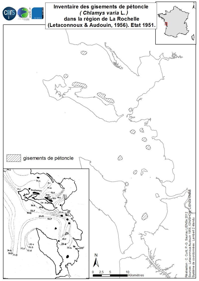
La distribution géographique des principaux gisements du pétoncle Chlamys varia L. aujourd’hui nommé Mimachlamys varia (Linné, 1758) a été dressée en 1951 par Letaconnoux & Audouin (1956) pour la région de La Rochelle englobant les Pertuis Breton et d’Antioche. L’inventaire porte sur les principaux gisements naturels de pétoncle du Pertuis Breton, du Pertuis d’Antioche jusqu’au Pertuis de Maumusson puis détaille les structures d’âge de deux populations issues du banc du Bûcheron et du banc de la Flotte dans le Pertuis Breton. L’analyse des conditions thermiques et salines en 1951-1952 permet aux auteurs de préciser le régime hydrologique propre aux bancs de pétoncle : marin (30 à 35 de salinité) et non perturbé par l’influence des eaux peu salées issues des panache fluviaux de la Sèvre et de la Charente, zone peu profonde au-dessus de l’isobathe des -15 m jusqu’à l’infralittoral exondable. Sont localisés treize bancs de pétoncle dont cinq dans le Pertuis Breton (en particulier les bancs du Bûcheron et de La Flotte qui sont les plus étendus), sept dans le Pertuis d’Antioche (situé le long des côtes de La Rochelle et d’Angoulin et à proximité de l’île d’Aix) et un au cœur du bassin de Marennes-Oléron (à proximité du banc de Lamouroux). La toponymie des gisements de pétoncle est issue des cartes IGN actuelles sauf pour les bancs du Bûcheron et de la Flotte clairement identifiés par Letaconnoux & Audouin (1956).
-
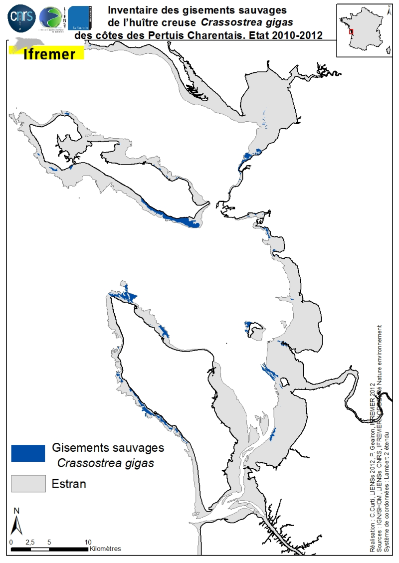
La distribution géographique des principaux gisements sauvages de l’huître creuse Crassostrea gigas (Thunberg, 1793) des côtes des Pertuis Charentais a été dressée de 2010 à 2012. L’inventaire porte sur les gisements naturels d’estrans (+ 6 à 0 m cote marine) et compile deux sources cartographiques : 1) les inventaires quantitatifs réalisés en 2010 par l’Ifremer depuis la Tranche sur Mer (Vendée) jusqu’à Vaux-sur-Mer en 21 sites représentatifs pour estimer les stocks sauvages d’huîtres creuses et 2) les inventaires cartographiques des habitats marins intertidaux réalisés principalement par LIENSs (en coopération avec CREOCEAN, IODDE, Ré Nature Environnement et GEO-Transfert) dans le cadre du projet CARTHAM Natura 2000 en mer de l’Agence des Aires Marines Protégées. Les méthodologies utilisées par Ifremer pour estimer les superficies colonisées combinent analyses thématiques sous Système d’Informations Géographiques (SIG) et validations terrain (Soletchnik et al., 2012). Les méthodologies utilisées par LIENSs pour estimer l’extension de l’habitat intertidal de l’huître creuse combinent analyses d’images aériennes, télédétection, validations terrain et analyses thématiques sous SIG (Cajeri et al., 2012).