 Catalogue PIGMA
European Space Agency (ESA)
Type of resources
Available actions
Topics
Keywords
Contact for the resource
Provided by
Years
Formats
Representation types
Update frequencies
status
Resolution
-
-
This dataset provides detections of fronts derived from high resolution remote sensing SST observations by SEVIRI L3C from OSISAF over Western Europe region. The data are available through HTTP and FTP; access to the data is free and open. In order to be informed about changes and to help us keep track of data usage, we encourage users to register at: https://forms.ifremer.fr/lops-siam/access-to-esa-world-ocean-circulation-project-data/ This dataset was generated by OceanDataLab and is distributed by Ifremer / CERSAT in the frame of the World Ocean Circulation (WOC) project funded by the European Space Agency (ESA).
-
This dataset provides detections of fronts derived from low resolution optimally interpolated remote sensing microwave SST L4 from REMSS over North Atlantic region. The data are available through HTTP and FTP; access to the data is free and open. In order to be informed about changes and to help us keep track of data usage, we encourage users to register at: https://forms.ifremer.fr/lops-siam/access-to-esa-world-ocean-circulation-project-data/ This dataset was generated by OceanDataLab and is distributed by Ifremer / CERSAT in the frame of the World Ocean Circulation (WOC) project funded by the European Space Agency (ESA).
-
This dataset provides Level 4 total current including geostrophy and a data-driven approach for Ekman and near-inertial current, based on a convolution between drifter observation and wind history, to fit empirically a complex and time-lag dependant transfert function between ERA5 wind stress and current The data are available through HTTP and FTP; access to the data is free and open. In order to be informed about changes and to help us keep track of data usage, we encourage users to register at: https://forms.ifremer.fr/lops-siam/access-to-esa-world-ocean-circulation-project-data/ This dataset was generated by Datlas and is distributed by Ifremer / CERSAT in the frame of the World Ocean Circulation (WOC) project funded by the European Space Agency (ESA).
-
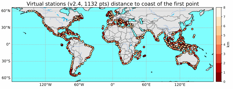
Until recently, classical radar altimetry could not provide reliable sea level data within 10 km to the coast. However dedicated reprocessing of radar waveform together with geophysical corrections adapted for the coastal regions now allows to fill this gap at a large number of coastal sites. In the context of the Climate Change Initiative Sea Level project of the European Space Agency, we have recently performed a complete reprocessing of high resolution (20 Hz, i.e., 350m) along-track altimetry data of the Jason-1, Jason-2 and Jason-3 missions over January 2002 to June 2021 along the coastal zones of Northeast Atlantic, Mediterranean Sea, whole African continent, North Indian Ocean, Southeast Asia, Australia and North and South America. This reprocessing has provided valid sea level data in the 0-20 km band from the coast. More than 1000 altimetry-based virtual coastal stations have been selected and sea level anomalies time series together with associated coastal sea level trends have been computed over the study time span. In the coastal regions devoid from tide gauges (e.g., African coastlines), these virtual stations offer a unique tool for estimating sea level change close to the coast (typically up to 3 km to the coast but in many instances up to 1 km or even closer). Results show that at most of the virtual stations, the rate of sea level rise at the coast is similar to the rate offshore (15 km away from the coast). However, at some stations, the sea level rate in the last 3-4 km to the coast is either faster or slower than offshore.