 Catalogue PIGMA
0.05 degree
Type of resources
Topics
Keywords
Contact for the resource
Provided by
Years
Formats
Representation types
Update frequencies
status
Resolution
-
Level 3 hourly sub-skin Sea Surface Temperature derived from Meteosat at 41.5° longitude, covering 60S-60N and 18.5W-101.5E and re-projected on a 0.05° regular grid, in GHRSST compliant netCDF format. The satellite input data has successively come from Meteosat at 41.5° longitude level 1 data processed at EUMETSAT. SST is retrieved from SEVIRI using a multi-spectral algorithm and a cloud mask. Atmospheric profiles of water vapor and temperature from a numerical weather prediction model, Sea Surface Temperature from an analysis, together with a radiative transfer model, are used to correct the multispectral algorithm for regional and seasonal biases due to changing atmospheric conditions.The quality of the products is monitored regularly by daily comparison of the satellite estimates against buoy measurements. The product format is compliant with the GHRSST Data Specification (GDS) version 2. Users are advised to use data only with quality levels 3, 4 and 5.
-

-

Level 3 hourly sub-skin Sea Surface Temperature derived from Meteosat at 0° longitude, covering 60S-60N and 60W-60E and re-projected on a 0.05° regular grid, in GHRSST compliant netCDF format. The satellite input data has successively come from Meteosat level 1 data processed at EUMETSAT. SST is retrieved from SEVIRI using a multi-spectral algorithm and a cloud mask. Atmospheric profiles of water vapor and temperature from a numerical weather prediction model, Sea Surface Temperature from an analysis, together with a radiative transfer model, are used to correct the multispectral algorithm for regional and seasonal biases due to changing atmospheric conditions.The quality of the products is monitored regularly by daily comparison of the satellite estimates against buoy measurements. The product format is compliant with the GHRSST Data Specification (GDS) version 2. Users are advised to use data only with quality levels 3, 4 and 5.
-
Data record (2004-2012) of level 3 hourly sub-skin Sea Surface Temperature derived from Meteosat at 0° longitude, covering 60S-60N and 60W-60E and re-projected on a 0.05° regular grid, in GHRSST compliant netCDF format. The satellite input data come from the imager SEVIRI on MSG satellites (Meteosat-8 and Meteosat-9). SST is retrieved from SEVIRI infrared channels (10.8 and 12.0 µm) using a multispectral algorithm and the cloud mask from CM SAF. NWP outputs (temperature and humidity profiles), OSTIA Sea Surface Temperature re-analysis and analysis, together with a radiative transfer model (RTTOV), are used to correct the multispectral algorithm for regional and seasonal biases due to changing atmospheric conditions. The product format is compliant with the GHRSST Data Specification (GDS) version 2. Users are advised to use data only with quality levels 3,4 and 5.
-
Level 3 twice-daily sub-skin Sea Surface Temperature derived from AVHRR on Metop-A, global and re-projected on a 0.05° regular grid, in GHRSST compliant netCDF format. The satellite input data has successively come from Metop-A and Metop-B level 1 data processed at EUMETSAT. SST is retrieved from AVHRR infrared channels (3.7, 10.8 and 12.0 µm) using a multi-spectral algorithm and a cloud mask. Atmospheric profiles of water vapor and temperature from a numerical weather prediction model, Sea Surface Temperature from an analysis, together with a radiative transfer model, are used to correct the multispectral algorithm for regional and seasonal biases due to changing atmospheric conditions.The quality of the products is monitored regularly by daily comparison of the satellite estimates against buoy measurements. The product format is compliant with the GHRSST Data Specification (GDS) version 2. Users are advised to use data only with quality levels 3, 4 and 5.
-

Level 3 twice-daily sub-skin Sea Surface Temperature derived from AVHRR on Metop-B, global and re-projected on a 0.05° regular grid, in GHRSST compliant netCDF format. The satellite input data has successively come from Metop-A and Metop-B level 1 data processed at EUMETSAT. SST is retrieved from AVHRR infrared channels (3.7, 10.8 and 12.0 µm) using a multi-spectral algorithm and a cloud mask. Atmospheric profiles of water vapor and temperature from a numerical weather prediction model, Sea Surface Temperature from an analysis, together with a radiative transfer model, are used to correct the multispectral algorithm for regional and seasonal biases due to changing atmospheric conditions.The quality of the products is monitored regularly by daily comparison of the satellite estimates against buoy measurements. The product format is compliant with the GHRSST Data Specification (GDS) version 2. Users are advised to use data only with quality levels 3, 4 and 5.
-
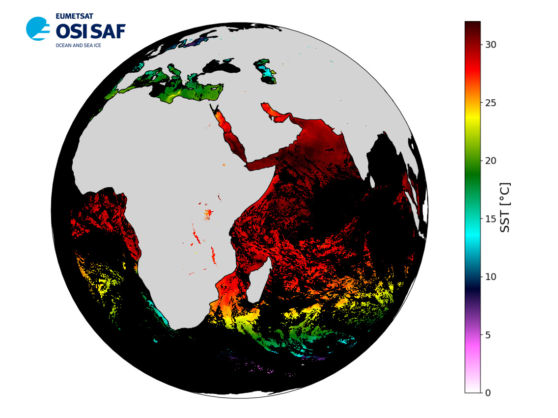
A Group for High Resolution Sea Surface Temperature (GHRSST) dataset for the Eastern Atlantic Region from the Spinning Enhanced Visible and InfraRed Imager (SEVIRI) on the MSG satellites (Meteosat-8 and Meteosat-9). The European Organization for the Exploitation of Meteorological Satellites (EUMETSAT),Ocean and Sea Ice Satellite Application Facility (OSI SAF) has reprocessed SST products in (long) delayed-mode from MSG/SEVIRI. SST is retrieved from the SEVIRI infrared channels (10.8 and 12.0 micrometer) using a multispectral algorithm and the cloud mask (CM) from OSI SAF. Atmospheric profiles of water vapor and temperature from a numerical weather prediction (NWP) model, OSTIA Sea Surface Temperature re-analysis and analysis, together with a radiatiave transfer model (RTTOV), are used to correct the multispectral algorithm for regional and seasonal biases due to changing atmospheric conditions. Every 15 minutes slot is processed at full satellite resolution. The operational products are then produced by remapping over a 0.05 degree regular grid (60S-60N and 60W-60E) SST fields obtained by aggregating all 15 minute SST data available in one hour time, and the priority being given to the value the closest in time to the product nominal hour. The product format is compliant with the GHRSST Data Specification (GDS) version 2.
-
A global Group for High Resolution Sea Surface Temperature (GHRSST) Level 3 Collated (L3C) dataset derived from the Advanced Very High Resolution Radiometer (AVHRR) on the European Meteorological Operational-A (MetOp-A) platform (launched 19 Oct 2006). The European Organization for the Exploitation of Meteorological Satellites (EUMETSAT), Ocean and Sea Ice Satellite Application Facility (OSI SAF) is producing SST products in near real time from Metop/AVHRR. Global AVHRR level 1b data are acquired at Meteo-France/Centre de Meteorologie Spatiale (CMS) through the EUMETSAT/EUMETCAST system. SST is retrieved from the AVHRR infrared channels (3.7, 10.8 and 12.0 micrometer) using a multispectral algorithm. Atmospheric profiles of water vapor and temperature from a numerical weather prediction model, together with a radiatiave transfer model, are used to correct the multispectral algorithm for regional and seasonal biases due to changing atmospheric conditions. This global L3C product is derived from full resolution AVHRR l1b data that are re-mapped onto a 0.05 degree grid twice daily. The product format is compliant with the GHRSST Data Specification (GDS) version 2.
-
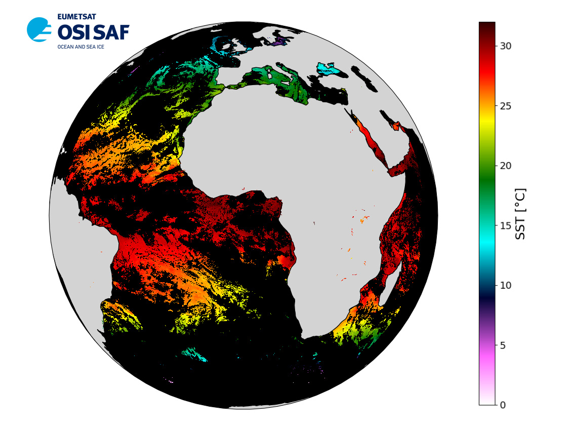
A Group for High Resolution Sea Surface Temperature (GHRSST) dataset for the Eastern Atlantic Region from the Spinning Enhanced Visible and InfraRed Imager (SEVIRI) on the Meteosat Second Generation (MSG-3) satellites (launched 5 July 2012). The European Organization for the Exploitation of Meteorological Satellites (EUMETSAT), Ocean and Sea Ice Satellite Application Facility (OSI SAF) is producing SST products in near real time from MSG/SEVIRI. SEVIRI level 1.5 data are acquired at Meteo-France/Centre de Meteorologie Spatiale (CMS) through the EUMETSAT/EUMETCAST system. SST is retrieved from the SEVIRI infrared channels (10.8 and 12.0 micrometer) using a multispectral algorithm. Atmospheric profiles of water vapor and temperature from a numerical weather prediction model, together with a radiatiave transfer model, are used to correct the multispectral algorithm for regional and seasonal biases due to changing atmospheric conditions. Every 15 minutes slot is processed at full satellite resolution. The operational products are then produced by remapping over a 0.05 degree regular grid (60S-60N and 60W-60E) SST fields obtained by aggregating all 15 minute SST data available in one hour time, and the priority being given to the value the closest in time to the product nominal hour. The product format is compliant with the GHRSST Data Specification (GDS) version 2.
-
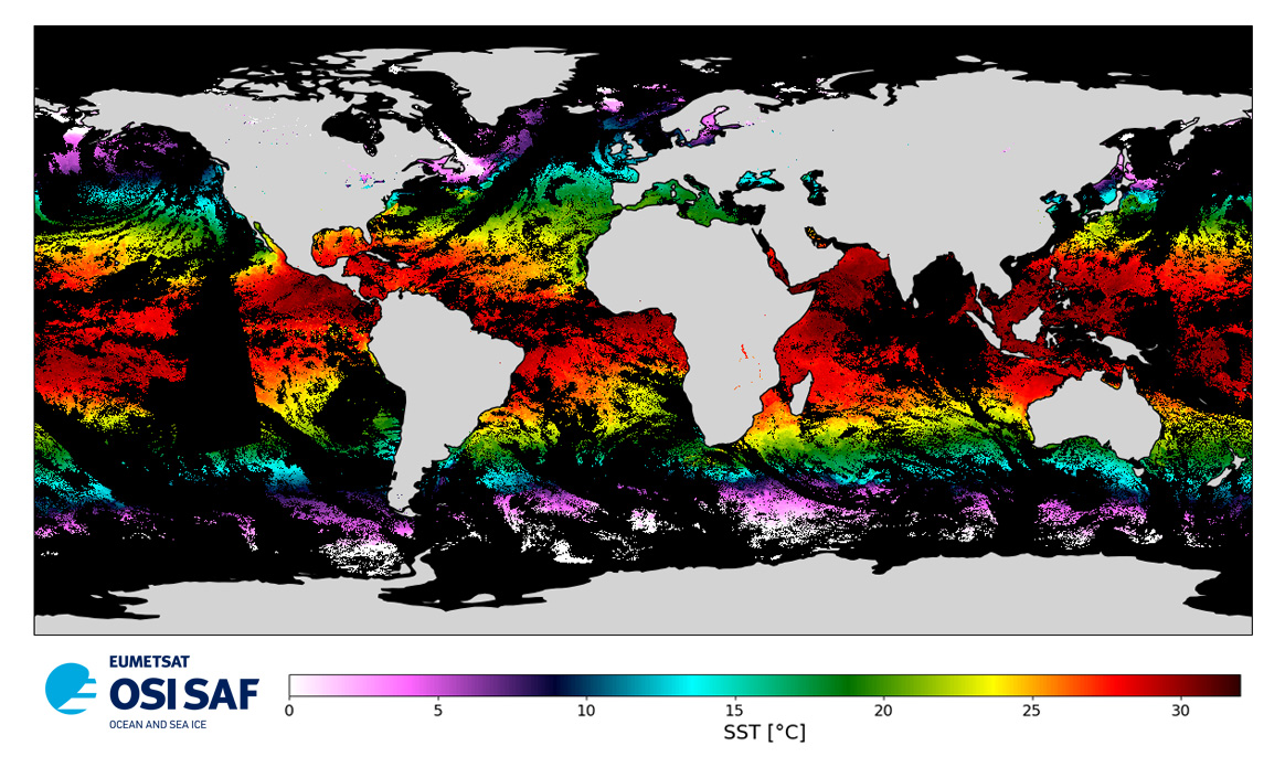
A Group for High Resolution Sea Surface Temperature (GHRSST) Level 4 sea surface temperature analysis produced daily on an operational basis by the Danish Meteorological Institute (DMI) using an optimal interpolation (OI) approach on a global 0.05 degree grid. The analysis is based upon nighttime GHRSST L2P skin and subskin SST observations from several satellites. The sensors include the Advanced Very High Resolution Radiometer (AVHRR), the Spinning Enhanced Visible and Infrared Imager (SEVIRI), the Advanced Microwave Scanning Radiometer 2 (AMSR2), the Visible Infrared Imager Radiometer Suite (VIIRS), and the Moderate Resolution Imaging Spectroradiometer (MODIS) on Aqua. An ice field from the EUMETSAT OSI-SAF is used to mask out areas with ice. This dataset adheres to the version 2 GHRSST Data Processing Specification (GDS).