 Catalogue PIGMA
utilitiesCommunication
Type of resources
Available actions
Topics
Keywords
Contact for the resource
Provided by
Years
Formats
Representation types
Update frequencies
status
Service types
Scale
Resolution
-

Gestion de la taxe de séjour des Etablissements Touristiques aux forfaits (Montant/suivi déclaration/suivi facturation) à l'échelle des communautés de communes.
-

Zone arrière du point de mutualisation (ZAPM) des territoires gérés par la SPL NATHD déployées
-

Gestion de la taxe de séjour des Établissements Touristiques aux réels (montant/suivi déclaration/suivi facturation) à l'échelle des communautés de communes.
-

Prises IPE présentes sur les territoires gérés par la SPL NATHD
-

Historiquement l'Agence Technique Départementale a été créée pour accompagner les maîtres d'ouvrage dans la réalisation des bâtiments ou infrastructures communaux. Elle a depuis développé un savoir-faire particulier grâce à une équipe technique performante pour accompagner les élus dans l'aide à la décision ou plus largement dans les réflexions à mener sur leur territoire. Aujourd'hui, avec le désengagement progressif des services d'ingénierie de l'Etat, l'ATD permet de conserver pour les collectivités Territoriales qui y adhèrent une offre d'ingénierie publique Territoriale compétente. Les missions statutaires constituées par les études de faisabilité ou de simple diagnostic sont désormais complétées par des missions d'assistance technique en phase pré-opérationnelles réalisées uniquement dans le cadre de prestations intégrées. L'ensemble de ces missions reste strictement circonscrit dans la sphère du maître d'ouvrage, l'ATD n'assurant pas de mission de maîtrise d'œuvre.
-

Particuliers bénéficiant du portage de repas à domicile
-
Réseau TERÉGA (ex-TIGF) sur le département des Landes. Servitudes s'appliquant aux canalisations de transport de gaz ainsi que le linéaire de réseau abandonné.
-

Réseaux d'assainissement collectif des collectivités territoriales de Charente ayant transmis leurs données à l'ATD16 pour intégration dans le SIG Départemental. La donnée n'est pas complète car elle est intégrée au compte goutte pour le compte des collectivités. La donnée est agrégée à l'échelle départementale dans le standard RAEPA
-
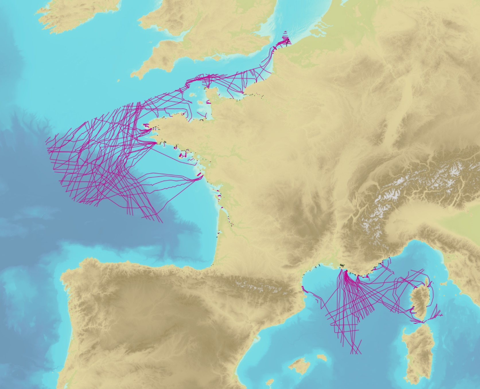
The product contains a description of submarine cables and pipelines brought to the attention of Shom on French areas of responsibility. These are 2D linear objects of the seabed that divide into two categories: • The submarine cables: these are cables placed on the seabed where electricity or information (telecommunication) flows. They represent the vast majority of objects (more than 90%); • Emissaries and submarine pipes: these are pipes that allow the discharge, sampling or circulation of fluids.
-
Ensemble de données permettant de matérialiser les différents éléments constituant un plan de cimetière communal. Limites de cimetière, Murs, Clôtures, Espace verts Emplacements, Monuments, Allées, Secteurs Bâtiments, Points d'eaux, déchets, etc... Ces données sont intégrées au SIG Départemental mis en œuvre par l'ATD16 permettant aux communes de gérer leurs concessions de cimetière via un logiciel métier.