 Catalogue PIGMA
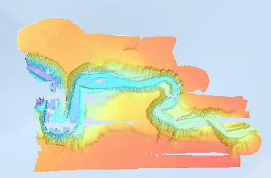
Bathymétrie - canyon de Capbreton (campagne SEDYMAQ3, 2012)
Bathymétrie du canyon de Capbreton (campagne SEDYMAQ3 en 2012), au pas de 2 mètres (projection Mercator latitude conservée 44°N). Ce Modèle Numérique de Terrain est calculé à partir des données acoustiques du sondeur multifaisceau EM2040 du N/O Thalia.
Référence verticale: Niveau des plus basses mers astronomiques PBMA (LAT)
Description de la campagne : GILLET Hervé (2012) SEDYMAQ3 cruise, RV Thalia, https://doi.org/10.17600/12070080
Simple
- Date (Publication)
- 2025-04-22
- Date (Creation)
- 2017-04-28
- Credit
- UMR CNRS 5805 EPOC - OASU
- Discipline
-
- Bathymetry
- Use limitation
- CC-BY (Creative Commons - Attribution)
- Access constraints
- Other restrictions
- Use constraints
- License
- Other constraints
- Pas de restriction d'accès public
- Use limitation
- Ne pas utiliser pour la navigation
- Aggregate Datasetindentifier
- 7c02b2a1-df4f-405c-8e2f-12180bbf237f
- Association Type
- Cross reference
- Spatial representation type
- Grid
- Denominator
- 4000
- Distance
- 2 meter
- Metadata language
- Français
- Character set
- UTF8
))
- Begin date
- 2012-06-03
- End date
- 2012-06-11
- Unique resource identifier
- WGS84 / WORLD MERCATOR (EPSG3395) latitude 44°N
- Codespace
- EPSG
- Version
- 7.4
- Number of dimensions
- 2
- Dimension name
- Column
- Dimension size
- 3266
- Dimension name
- Row
- Dimension size
- 2000
- Cell geometry
- Area
- Distribution format
-
-
GeoTIFF
(
1.0
)
-
GeoTIFF
(
1.0
)
- OnLine resource
-
SEDYMAQ3_Capbreton_2m_BATHY
(
NETWORK:LINK
)
SEDYMAQ3 : bathymétrie du canyon de Capbreton
- Protocol
- COPYFILE
- Name
- SEDYMAQ3_Capbreton_2m_BATHY
- Description
- SEDYMAQ3 : bathymétrie du canyon de Capbreton
- OnLine resource
- SEDYMAQ3_Capbreton_2m_BATHY ( OGC:WMS )
- Hierarchy level
- Dataset
Conformance result
- Date (Publication)
- 2010-12-08
- Explanation
- See the referenced specification
- Statement
- Traitements réalisés : Ifremer CTDI/GM C. Guérin, 2016.
- File identifier
- 43557de3-d052-4d60-b945-6c4682e7eccc XML
- Metadata language
- Français
- Character set
- UTF8
- Hierarchy level
- Dataset
- Date stamp
- 2025-04-25T08:28:56.774796Z
- Metadata standard name
- ISO 19115:2003/19139 - SEXTANT
- Metadata standard version
- 1.0
Overviews
Spatial extent
Provided by
