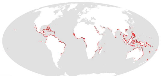
World Atlas of Mangroves (version 3.1). A collaborative project of ITTO, ISME, FAO, UNEP-WCMC, UNESCO-MAB, UNU-INWEH and TNC. London (UK): Earthscan, London. 319 pp
This dataset shows the global distribution of mangroves, and was produced as joint initiatives of the International Tropical Timber Organization (ITTO), International Society for Mangrove Ecosystems (ISME), Food and Agriculture Organization of the United Nations (FAO), UN Environment World Conservation Monitoring Centre (UNEP-WCMC), United Nations Educational, Scientific and Cultural Organization’s Man and the Biosphere Programme (UNESCO-MAB), United Nations University Institute for Water, Environment and Health (UNU-INWEH) and The Nature Conservancy (TNC). Major funding was provided by ITTO through a Japanese Government project grant; the project was implemented by ISME.
Simple
- Date (Revision)
- 2021-03-01
- Date (Publication)
- 2010-01-01
- Identifier
- c5281177-c9e6-4226-acef-c28c90c7a0c3
- Purpose
- This dataset was used in the World Atlas of Mangroves (Spalding et al. 2010); some statistics in the publication are not derived from the dataset (see annex 3, p. 288 for details of the data used).
- Credit
- International Tropical Timber Organization
- Credit
- International Society for Mangrove Ecosystems
- Credit
- Food and Agriculture Organization of the United Nations
- Credit
- UN Environment World Conservation Monitoring Centre
- Credit
- UN Educational, Scientific and Cultural Organization’s Man and the Biosphere Programme
- Credit
- UN University, Institute for Water Environment and Health
- Credit
- The Nature Conservancy
- Thèmes Sextant
-
- /Biological Environment/Habitats
- GEMET - INSPIRE themes, version 1.0
-
- Habitats and biotopes
- Mission Atlantic - Resources
-
- Data
- Mission Atlantic - Case Studies
-
- Canary Current system
- Atlantic Ocean
- Mission Atlantic - BODC Parameters
-
- /Environment/Habitat
- Mission Atlantic - Data type (DMP)
-
- Spatial data products
- Mission Atlantic - Work Package
-
- WP1 Atlantic Ocean IEA
- Use limitation
- UNEP-WCMC General Data License
- Other constraints
- For commercial use, please contact business-support@unep-wcmc.org and isme@mangrove.or.jp. Please also refer to the license file (“WCMC-011-AtlasMangrove2010-License.pdf”) distributed with the dataset. Please send any modification and revision of the dataset to the ISME Secretariat (Faculty of Agriculture, University of the Ryukyus, Senbaru 1, Nishihara, Okinawa 903-0129 Japan; isme@mangrove.or.jp ).
- Spatial representation type
- Vector
- Metadata language
- English
- Character set
- UTF8
- Topic category
-
- Oceans
N
S
E
W
))
- Begin date
- 1999-01-01
- End date
- 2003-01-01 Before
- Unique resource identifier
- EPSG:4326
- Distribution format
-
-
ESRI Shapefile
(
1.0
)
-
ESRI Shapefile
(
1.0
)
- OnLine resource
- World Atlas of Mangroves ( DOI )
- OnLine resource
- Downlaod data ( WWW:DOWNLOAD )
- OnLine resource
- World Atlas of Mangroves By Mark Spalding, Mami Kainuma, Lorna Collins ( WWW:LINK-1.0-http--publication-URL )
- Hierarchy level
- Dataset
- Statement
- The dataset was created mostly from satellite imagery processed at UNEP-WCMC or FAO. For a number of countries, existing (WCMC-012 (1997)) or newly available (vector) data were incorporated. The methodology is detailed in chapter 3 of Spalding et al. (2010), which is distributed with the dataset ("WCMC-011-AtlasMangrove2010-Methodology.pdf")
- File identifier
- c5281177-c9e6-4226-acef-c28c90c7a0c3 XML
- Metadata language
- English
- Character set
- UTF8
- Hierarchy level
- Dataset
- Date stamp
- 2022-02-25T12:29:54.788Z
- Metadata standard name
- ISO 19115:2003/19139 - SEXTANT
- Metadata standard version
- 1.0
Point of contact
Ifremer
-
Sextant
ZI Pointe du Diable
,
Plouzane
,
Brittany
,
29280
,
France
https://sextant.ifremer.fr/eng
Overviews

Spatial extent
N
S
E
W
))
Provided by

Associated resources
Not available
 Catalogue PIGMA