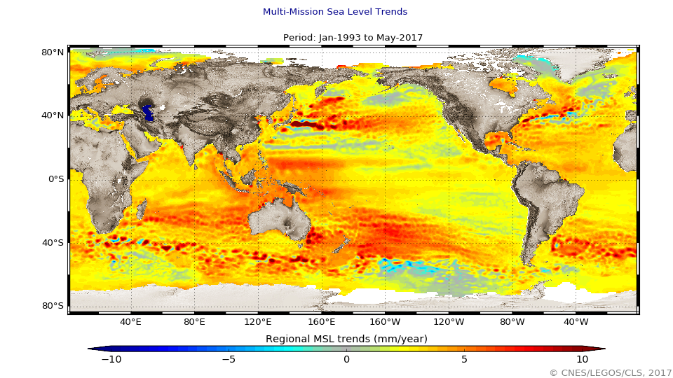
Mean Sea Level Rise
The global mean level of the oceans is one of the most important indicators of climate change. It incorporates the reactions from several different components of the climate system. Precise monitoring of changes in the mean level of the oceans, particularly through the use of altimetry satellites, is vitally important, for understanding not just the climate but also the socioeconomic consequences of any rise in sea level.
Simple
- Date (Creation)
- 1993-01-01
- Credit
- AVISO+
- Centre de données ODATIS
-
- CDS-AVISO
- Keywords
-
- Indicateurs océaniques
- Type de jeux de donnée ODATIS
-
- Analysis data
- ODATIS aggregation parameters and Essential Variable names
-
- Sea surface height
- Use limitation
- Licence
- Access constraints
- Other restrictions
- Use constraints
- Other restrictions
- Other constraints
- Citation: Crédits CNES/LEGOS/CLS
- Spatial representation type
- Grid
- Metadata language
- Français
- Character set
- UTF8
- Topic category
-
- Oceans
N
S
E
W
))
- Begin date
- 1993-01-01
- Geometric object type
- Complex
- Distribution format
-
-
(
)
-
(
)
- OnLine resource
- AVISO+ ( WWW:LINK )
- OnLine resource
- Accès aux données txt ( WWW:LINK )
- OnLine resource
- Accès aux données .nc ( WWW:LINK )
- Hierarchy level
- Dataset
- Statement
- With the satellite altimetry missions, the global mean sea level (GMSL) has been calculated on a continual basis since January 1993. 'Verification' phases, during which the satellites follow each other in close succession (Topex/Poseidon--Jason-1, then Jason-1--Jason-2), help to link up these different missions by precisely determining any bias between them. Saral, Envisat, ERS-1 and ERS-2 are also used, after being adjusted on these reference missions, in order to compute Mean Sea Level at high latitudes (higher than 66°N and S), and also to improve spatial resolution by combining all these missions together. In addition, permanent monitoring of quality during the missions (Calval) and studies of the necessary corrections of altimetry data regularly add to our understanding and knowledge (see the Processing and corrections applied to each mission to obtain the reference mean sea level).
- File identifier
- eafa97cd-9bde-407a-a263-1ea8a040cfef XML
- Metadata language
- Français
- Character set
- UTF8
- Hierarchy level
- Dataset
- Date stamp
- 2024-10-15T14:39:31.276094Z
- Metadata standard name
- ISO 19115:2003/19139 - SEXTANT
- Metadata standard version
- 1.0
Overviews

Spatial extent
N
S
E
W
))
Provided by

Associated resources
Not available
 Catalogue PIGMA