 Catalogue PIGMA
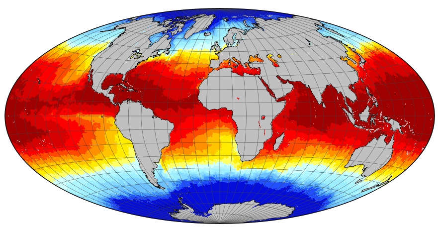
GHRSST Level 4 DMI_OI Global Foundation Sea Surface Temperature Analysis
A Group for High Resolution Sea Surface Temperature (GHRSST) gap-free (L4) Sea Surface Temperature (SST) analysis produced daily on an operational basis by the Danish Meteorological Institute (DMI) using an optimal interpolation (OI) approach on a global 0.05 degree grid.
Whereas along swath observation data essentially represent the skin or sub-skin SST, the L4 SST product is defined to represent the foundation (SSTfnd). SSTfnd is defined within GHRSST as the temperature at the base of the diurnal thermocline. It is so named because it represents the foundation temperature on which the diurnal thermocline develops during the day. SSTfnd changes only gradually along with the upper layer of the ocean, and by definition it is independent of skin SST fluctuations due to wind- and radiation-dependent diurnal stratification or skin layer response. SSTfnd corresponds to the temperature of the upper mixed layer which is the part of the ocean represented by the top-most layer of grid cells in most numerical ocean models. It is never observed directly by satellites, but it comes closest to being detected by infrared and microwave radiometers during the night, when the previous day's diurnal stratification can be assumed to have decayed.
The processing combines night-time GHRSST L2P skin and subskin SST observations from several satellites. The data is inter-calibrated and bias corrected before being merged and interpolated using an optimal interpolation scheme to provide daily gap-free fields. The optimal interpolation scheme uses the previous days analysis as a background field. An ice field from the EUMETSAT OSI-SAF is used to mask out areas with ice.
Simple
- Date (released)
- 2007-09-08
- Identifier
- DMI_OI-DMI-L4-GLOB-v1.0 /
- Status
- onGoing On going
- GEMET - INSPIRE themes, version 1.0
-
- Oceanographic geographical features
- Cersat - Parameter
-
- Ocean Temperature
- Cersat - Project
-
- GHRSST
- Cersat - Latency
-
- Less than 24 hours
- Cersat - GCMD parameter
-
- /Ocean Temperature/Sea Surface Temperature
- Use limitation
- None
- Access constraints
- unrestricted
- Use constraints
- Other restrictions
- Other constraints
- CC-BY (Creative Commons - Attribution)
- Other constraints
- Danish Meteorological Institute, Center for Ocean and Ice. 2007. GHRSST L4 DMI Global Sea Surface Temperature analysis. Ver. 1.0. PO.DAAC, CA, USA. Dataset accessed [YYYY-MM-DD] at https://doi.org/10.5067/GHGDM-4FD02
- Spatial representation type
- grid Grid
- Distance
- 0.05 degree
))
- Geographic identifier
- Global
- Begin date
- 2013-04-30
- Reference system identifier
- http://www.opengis.net/def/crs/EPSG/0/4326
- Distribution format
-
-
NetCDF
(
4
)
-
NetCDF
(
4
)
OnLine resource
- OnLine resource
-
Product notices
(
WWW:LINK
)
Product information
- OnLine resource
- Access data ( WWW:LINK )
- OnLine resource
- Digital Object Identifier (DOI) ( DOI )
- Hierarchy level
- Dataset
- Attribute description
- composite
- Processing level code
- L4 /
- File identifier
- edcd9174-4f81-4036-9617-d2526de053f3 XML
- Metadata language
- English
- Character set
- UTF8
- Hierarchy level
- Dataset
- Date stamp
- 2023-10-05T12:45:45.405Z
- Metadata standard name
- ISO 19115-3:2018 - Remote Sensing
Overviews
Spatial extent
Provided by
