 Catalogue PIGMA
Depth profiles of 210Pb, 226Ra and 137Cs in marine sediments of the Bay of Biscay
210Pb, 226Ra and 137Cs were measured by non-destructive gamma spectrometry on marine sediment cores, collected during RIKEAU 2002 cruise on board r/v Thalia, on the shelf of the Bay of Biscay
Simple
- Date (Publication)
- 2017
- Date (Revision)
- 2025-02-18
- Other citation details
- Schmidt Sabine (2017). Depth profiles of 210Pb, 226Ra and 137Cs in marine sediments of the Bay of Biscay. SEANOE. https://doi.org/10.17882/48056
- Theme
-
- Marine geology
- Use limitation
- CC-BY-NC-SA (Creative Commons - Attribution, No commercial usage, Sharing under the same conditions)
- Use constraints
- Other restrictions
- Date (Publication)
- 2005
- Unique resource identifier
- 10.1051/radiopro:2005s1-096
- Association Type
- Cross reference
- Initiative Type
- Study
- Unique resource identifier
- 10.17600/2070040
- Association Type
- Cross reference
- Initiative Type
- Platform
- Metadata language
- English
- Topic category
-
- Oceans
N
S
E
W
))
N
S
E
W
))
N
S
E
W
))
N
S
E
W
))
N
S
E
W
))
- Distribution format
-
-
CSV
(
)
-
CSV
(
)
- OnLine resource
- Quality controlled data ( WWW:DOWNLOAD-1.0-link--download )
- OnLine resource
- DOI of the product ( WWW:LINK-1.0-http--metadata-URL )
- OnLine resource
- Seanoe ( rel-canonical )
- Hierarchy level
- Dataset
- File identifier
- seanoe:48056 XML
- Metadata language
- English
- Character set
- UTF8
- Hierarchy level
- Dataset
- Date stamp
- 2025-02-18
- Metadata standard name
- ISO 19115:2003/19139
- Metadata standard version
- 1.0
Overviews
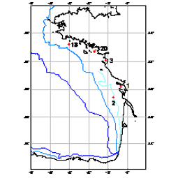
Location of the five investigated sediment cores
Spatial extent
N
S
E
W
N
S
E
W
N
S
E
W
N
S
E
W
N
S
E
W
Provided by

Associated resources
Not available