 Catalogue PIGMA
2017
Type of resources
Available actions
Topics
Keywords
Contact for the resource
Provided by
Years
Formats
Representation types
Update frequencies
status
Service types
Scale
Resolution
-
EMODnet Biology provides three keys services and products to users. 1)The data download toolbox allows users to explore available datasets searching by source, geographical area, and/or time period. Datasets can be narrowed down using a taxonomic criteria, whether by species group (e.g. benthos, fish, algae, pigments) or by both scientific and common name. 2) The data catalogue is the easiest way to access nearly 1000 datasets available through EMODnet Biology. Datasets can be filtered by multiple parameters via the advanced search from taxon, to institute, to geographic region. Each of the resulting datasets then links to a detailed fact sheet containing a link to original data provider, recommended citation, policy and other relevant information. Data Products - EMODnet Biology combines different data from datasets with overlapping geographic scope and produces dynamic maps of selected species abundance. The first products are already available and they focus on species whose data records are most complete and span for a longer term.
-
Ce jeu de données donne les intercommunalités sur le département de la Gironde.
-
Sit@del2 est la base de données du système statistique public relative à la construction neuve de logements et de locaux non résidentiels. Cette base est alimentée par les informations des permis de construire, permis d’aménager, permis de démolir et déclarations préalables. Ces données sont transmises chaque mois par les centres instructeurs des directions départementales de l’équipement et par les communes (ou groupements de communes) autonomes.
-
Ce jeu de données permet d'accéder aux 9 millions d'entreprises et 10 millions d'établissements actifs du répertoire Sirene de l'Insee qui enregistre quotidiennement leur état civil : quelle que soit leur forme juridique ; quel que soit leur secteur d'activité (industriels, commerçants, artisans, professions libérales, agriculteurs, collectivités territoriales, banques, assurances, associations...) ; situés en France métropolitaine, ainsi qu'en Guadeloupe, Martinique, Guyane, La Réunion, Mayotte, Saint-Barthélemy, Saint-Martin et Saint-Pierre-et-Miquelon. Les organismes publics ou privés et les entreprises étrangères qui ont une représentation ou une activité en France y sont également répertoriés. Le répertoire Sirene est ainsi la principale source exhaustive sur l'ensemble des entreprises et des établissements actifs. --- Etat de disponibilité de la donnée: - Data.gouv : répertoire SIREN téléchargeable au format csv et mise à jour quotidienne. - PIGMA : donnée de 2009 au format shape. - Géocatalogue : métadonnée au format csv du 01/01/2016.
-
Cartographie des écluses à poissons actuellement encore en place sur l'île de Ré
-
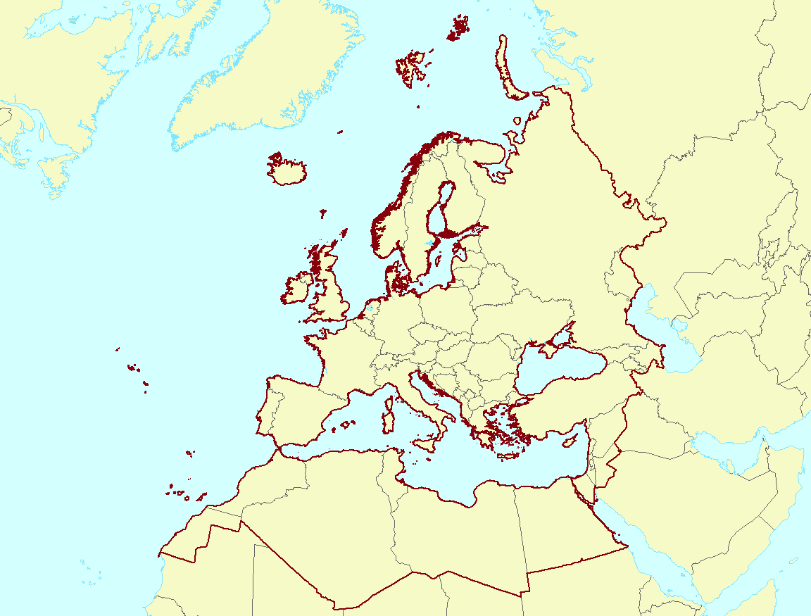
The EEA coastline for analysis is created for highly detailed analysis, e.g. 1:100 000, for geographical Europe. The coastline is a hybrid product obtained from projects using satellite imagery as data source: EUHYDRO (https://land.copernicus.eu/imagery-in-situ/eu-hydro) and GSHHG (http://www.soest.hawaii.edu/pwessel/gshhg/). The defining criteria was altitude level = 0 from EUDEM (https://land.copernicus.eu/pan-european/satellite-derived-products/eu-dem/view). Outside the coverage of the EUDEM, the coastline from GSHHG was used without modifications. A few manual amendments to the dataset were necessary to meet requirements from EU Nature Directives, Water Framework Directive and Marine Strategy Framework Directive. In 2015, several corrections were made in the Kalogeroi Islands (coordinates 38.169, 25.287) and two other Greek little islets (coordinates 36.766264, 23.604318), as well as in the peninsula of Porkkala (around coordinates 59.99, 24.42). In this revision (v3, 2017), 2 big lagoons have been removed from Baltic region, because, according to HELCOM, are freshwater lagoons.
-
The Global Sea Level Observing System (GLOSS) was established by the Intergovernmental Oceanographic Commission (IOC) of UNESCO in 1985 to establish a well-designed, high-quality in situ sea level observing network to support a broad research and operational user base. Various tide gauge networks have contributed to GLOSS, each with a different focus and each changing over time as research priorities evolve. The main component is the GLOSS Core Network (GCN), a global set of ~300 tide gauges that serves as the backbone of the global in situ sea level network. GCN gauges were allocated to each island or group of islands at intervals not closer than 500 km, and along continental coasts at intervals generally not less than 1000 km. Preference was given to islands in order to maximise exposure to the open ocean. Established in 1933, the Permanent Service for Mean Sea Level (PSMSL) is responsible for the collection, publication, analysis and interpretation of sea level data from the global network of tide gauges, including the GLOSS Core Network.
-

Nature de l'occupation du sol par commune et en m².
-
Temporal series (annual mean values) with error of estimation and Long Term Average (LTA) with error of estimation of total phosphate load for each river mouth where in situ data is available. Different sources can be mixed if any.
-

Gestion de la taxe de séjour des Etablissements Touristiques aux forfaits (Montant/suivi déclaration/suivi facturation) à l'échelle des communautés de communes.