 Catalogue PIGMA
CSV
Type of resources
Available actions
Topics
Keywords
Contact for the resource
Provided by
Years
Formats
Representation types
Update frequencies
status
Scale
Resolution
-

This is the FAO Fishery and Aquaculture Reference Data repository: Codes and reference data for fishing gear, species, currencies, commodities, countries and others.
-
Aires géographiques des appellations d'origine contrôlées (AOC)/protégées (AOP). Le fichier liste pour chaque commune, identifiée par son département, son nom et son code INSEE, les aires géographiques des appellations AOC/AOP qui se situent sur la commune
-

-
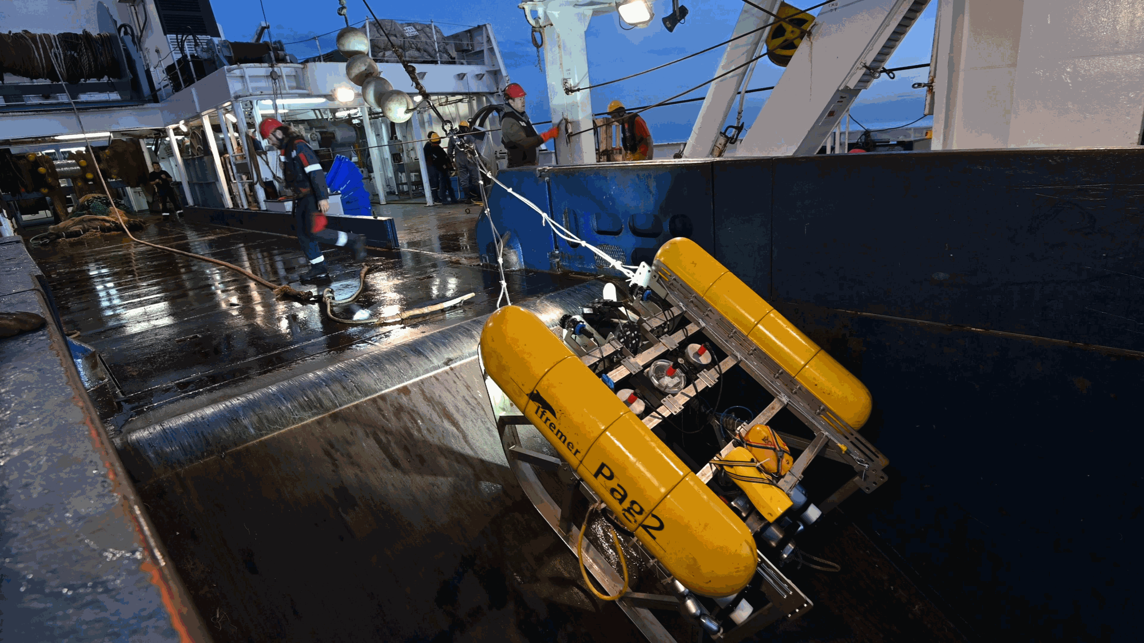
This folder contains two examples of PAGURE datasets, corresponding to three surveys: -CGFS conducted in 2018 in the English Channel (Northeast Atlantic) -EPIBENGOL conducted in 2019 in the Gulf of Lion (Western Mediterranean) -EVHOE conducted in 2020 in the Bay of Biscay and Celtic Shelf (Northeast Atlantic) Files include metadata for the sampling stations, annotation files. A readme tex file contains the links to the voyage metadata This folder is aimed at providing an example of documented underwater imagery dataset. These data are part of the data exchange conducted in the QuatreA collaboration between the French Research Institute for the Exploitation of the Sea (Ifremer), the Commonwealth Scientific and Industrial Research Organisation (CSIRO), and the University of Tasmania (UTAS).
-
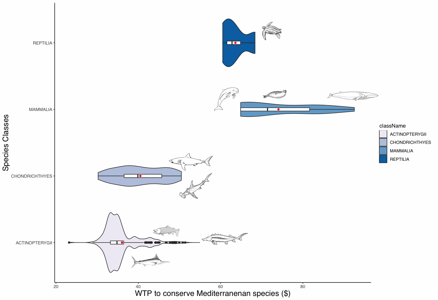
The willingness to pay (WTP) of people to protect animal populations can be used as a tool for these populations’ conservation. The WTP reflects the non-use value of animals, which can be significant for charismatic species. This value can be used as an economic criterion for decision-makers in order to recommend protective measures. The definition of the WTP to protect a species is challenging, as valuation methods are time-consuming and expensive. To overcome these limitations, we built a benefit transfer function based on 112 valuation studies and apply it to 440 Mediterranean marine species. We extracted these species from the IUCN database and retrieved some required parameters from, amongst others, the FishBase database. Marine mammals appear to have the highest WTP value followed in order by sea turtles, sharks and rays, and ray-finned fishes. Commercial fish species appear to have the highest values amongst the fish class.
-
The dataset dcm_dtb.txt contains bio-optical measurements and environmental parameters associated with Deep Chlorophyll Maxima (DCM) acquired by BGC-Argo profiling floats. For each BGC-Argo profile the data files includes the World Meteorological Organization (WMO) and profile numbers, the Data Assembly Center (DAC), the geographical position (LON and LAT), the date of the profile in Julian Day (JULD) and in YYYY-MM-DD format; the region of the profile (REGION, acronyms detailed in the region.txt file), the DCM zonal attribution (ZONE, acronyms detailed in the zone.txt file), the vertical resolution of measurements of the concentration of the chlorophyll a [Chla] and of the backscattering coefficient (bbp) within the 250 first meters, the Mixed Layer Depth (MLD, m), the qualification of the vertical profile (DCM_TYPE) as Deep Biomass Maximum (3), Deep photoAcclimation Maximum (2), or presenting no DCM (1); the depth of the DCM (DCM_DEPTH); the chlorophyll a concentration (CHLA_DCM, mg chla m-3 ) the backscattering coefficient (BBP_DCM, m-1), and the Brunt-Vaisala frequency (N2_DCM) at the DCM depth; the nitracline depth (NCLINE_DEPTH, m) and steepness (NCLINE_STEEP, µmol NO3 m-3 m-1), the mean nitrate concentration within the Mixed Layer (NO3_MEAN_MLD, µmol NO3 m-3), the mean daily Photosynthetically Available Radiation in the Mixed Layer (MEAN_IPAR_MLD, E m -1 d -1), the daily Photosynthetically Available Radiation at the nitracline depth (IPAR_NCLINE, E m-2 d-1); and the [Chla] measured by satellite (CHLA_SAT, mg chla m-3). The dataset shape_NASTG_ASEW.txt contains the seasonal median, the first and third quartiles of the [Chla] and of the bbp profiles for the North Atlantic Subtropical Gyre and Atlantic SubEquatorial Waters regions. The dataset climato_NASTG_ASEW.txt contains the monthly mean and standard deviations of the DCM depth (DCM_depth), the isolume depth of daily Photosynthetically Available Radiation of 20 E m-2 d-1 (iPAR_20), the nitracline depth, and the Mixed Layer Depth (MLD) for the profiles within the North Atlantic Subtropical Gyre and Atlantic SubEquatorial Waters regions. The qualification and processing of the BGC-Argo profiles, as well as the DCM detection (DCM_TYPE) and the estimation of the environmental parameters, were applied as described from Cornec, M., Claustre, H., Mignot, A., Guidi, L., Lacour, L., Poteau, A., D’Ortenzio, F.,Gentili, B., Schmechtig, C., (to be updated.) Deep Chlorophyll Maxima in the global ocean: occurrences, drivers and characteristics. Global Biogeochemical Cycles, to be updated The [Chla] satellite variable was obtained by the match of each BGC-Argo profile with a L3S [Chla] product from the Ocean Colour-Climate Change Initiative v4.0 database merging observations from MERIS, MODIS, VIIRS and SeaWiFs, at a monthly and 4x4-km-pixel resolution, up to December 31, 2019 (ftp://oc-cci-data:ELaiWai8ae@oceancolour.org/occci-v4.2/).
-
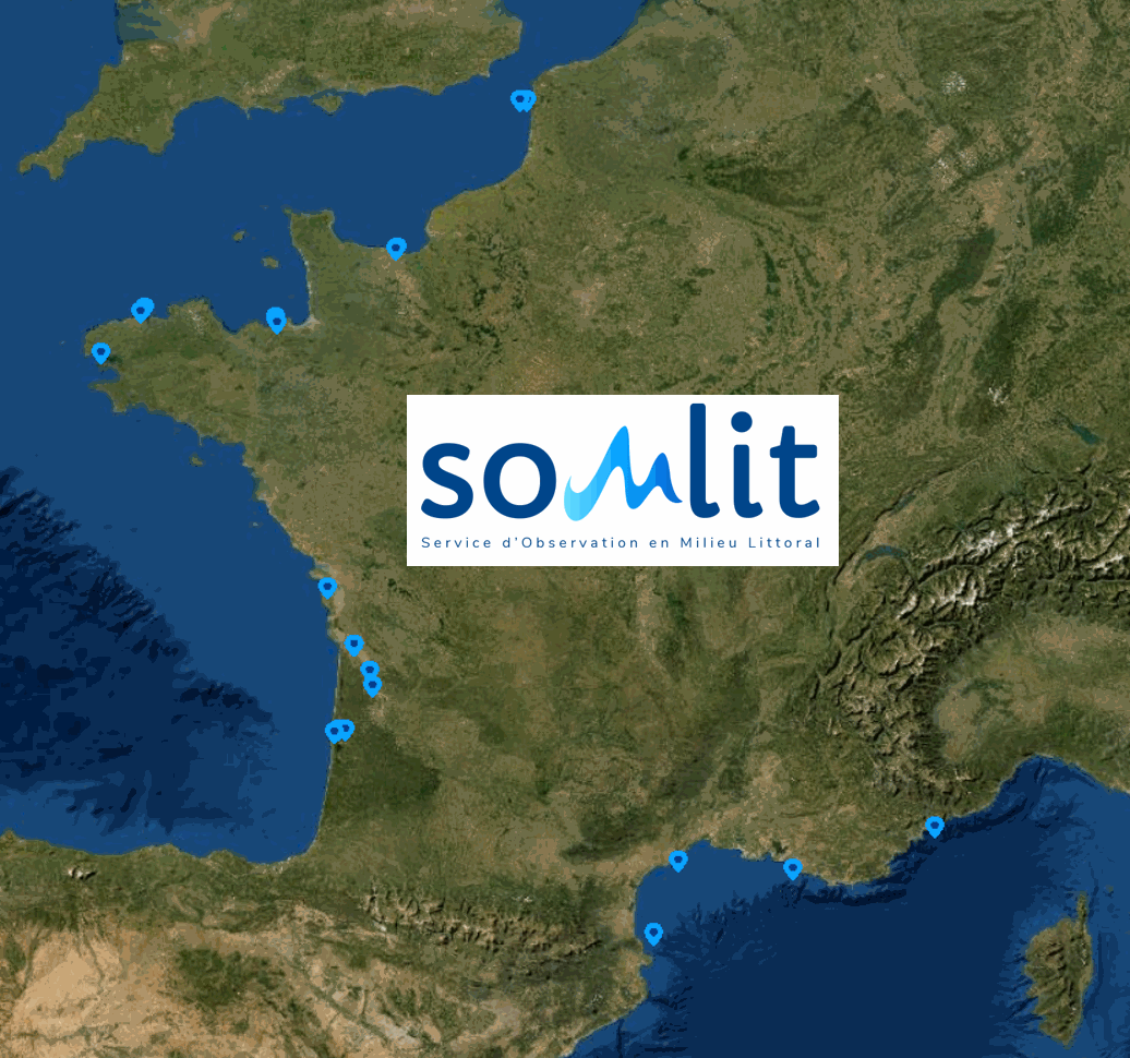
SOMLIT (Service d'Observation en Milieur Littoral) : a French Coastal Monitoring Network Coastal zones are where land, ocean and atmosphere interact. They are important for the exchange of matter and energy, and play a key role in (biogeo)chemical cycles at global scale. These environments are characterised by significant spatial and temporal variability of their physico-chemical and biological parameters due to local and seasonal meteorological drivers which are exacerbated by large-scale climate drivers (e.g. global warming, modification of the wind regime) and local-scale anthropogenic drivers (e.g. nutrient cycle changes linked to the use of fertilisers or the construction of large installations such as dams). These driving mechanisms are often interconnected. In the context of global warming (due to climate and human-induced changes), the identification and understanding of their impact on coastal marine and littoral ecosystems is essential. The scientific objective of SOMLIT is to 1) characterise the multi-decadal evolution of coastal marine and littoral ecosystems, and 2) determine the climatic and anthropogenic drivers. In order to meet this objective, a nationally coordinated multi-site monitoring system was set up in the mid-1990s. The observation strategy is the same for each of the 12 monitored ecosystems with fortnightly sampling and/or measurements, at high tide (for sites subject to tides): 1) in surface-water for a range of 15 parameters (temperature, salinity, dissolved oxygen, pH, nitrate, nitrite, ammonium, phosphate, silicate, suspended particulate matter, chlorophyll a, particulate organic carbon and nitrogen and stable isotopes of particulate organic carbon and nitrogen), 2) in surface-water for a range of 26 parameters of numbering and optical characteristics of pico- and nanoplankton), and 3) along the water column for temperature, salinity, fluorescence and PAR (vertical profiles of multi-parameter probes). SOMLIT’s activities are carried out under a quality assurance / quality control process based on the ISO 17025 standard. SOMLIT’s service provision objectives are to provide data and logistical support for research and other observation activities. SOMLIT has been officially accredited since 1996 as one of the CNRS (French National Centre for Scientific Research) National Observation Services (SNO). SOMLIT’s coordination is hosted by the Observatoire Aquitain des Sciences de l'Univers (University of Bordeaux / CNRS) and the service relies on strong partnerships with nine other institutions (University of Lille, University of the Littoral Opal Coast, University of Caen Normandy, Sorbonne University, University of Western Brittany, La Rochelle University, University of Montpellier, Aix Marseille University, National Museum of Natural History). SOMLIT is one of the nine networks that compose France’s Coastal Research Infrastructure (ILICO). SOMLIT has strong ties with ILICO’s other networks such as the SNOs MOOSE (Mediterranean Ocean Observing System on Environment), PHYTOBS (microphytoplankton monitoring) and COAST-HF (Coastal Ocean Observing System - High Frequency).
-
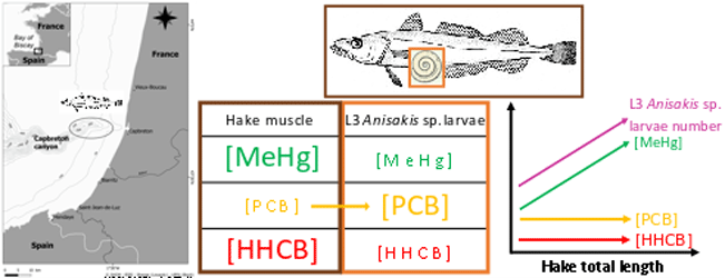
This dataset gathers isotopic ratios (carbon and nitrogen) and concentrations of both priority (mercury species and polychlorinated biphenyls congeners) and emerging (musks and sunscreens) micropollutants measured in a host-parasite couple (hake Merluccius merluccius muscle and in its parasite Anisakis sp) from the south of Bay of Biscay in 2018. In addition, the hake infection degree measured as the number of Anisakis sp. larvae was added for each hake collected.
-
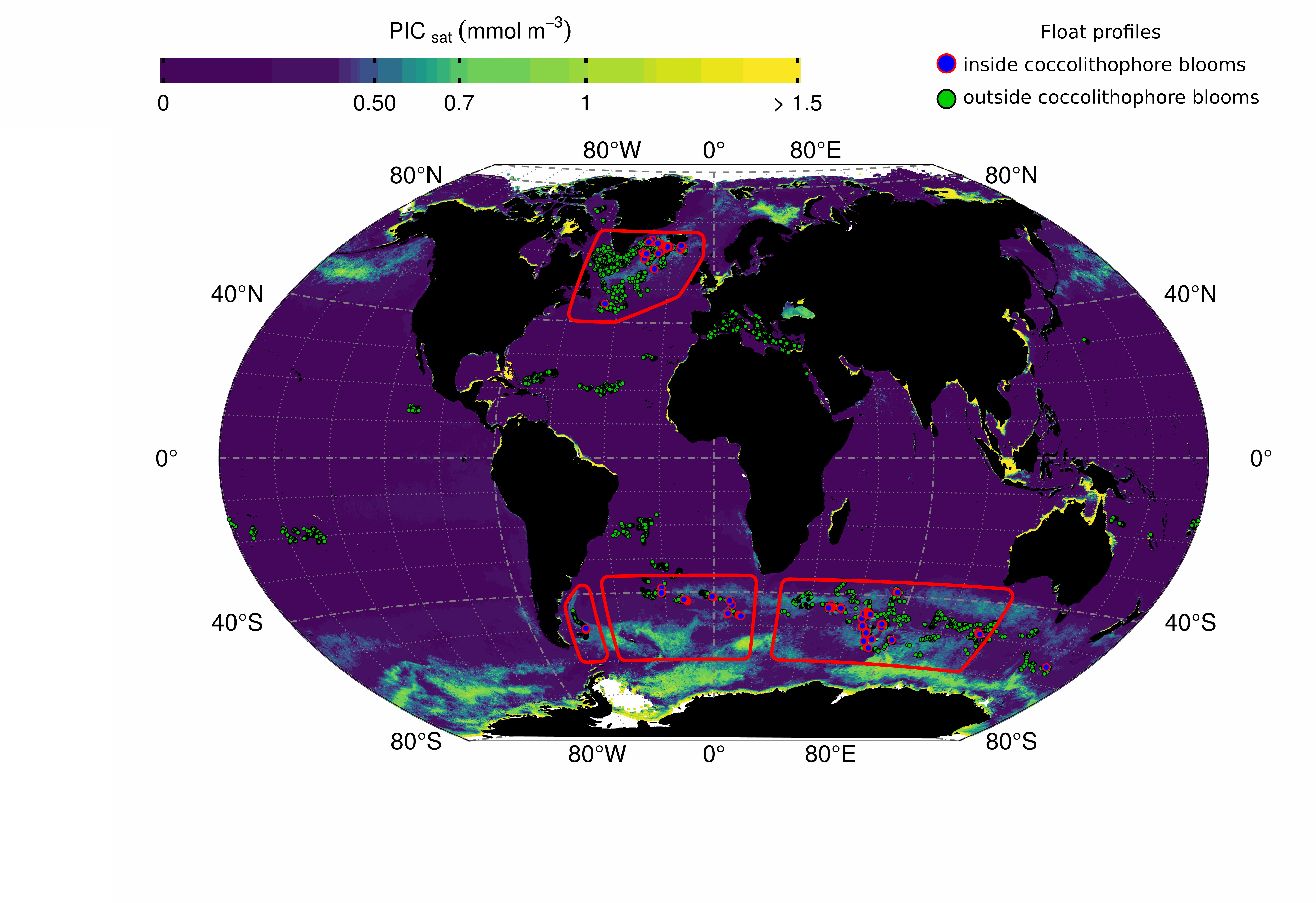
This dataset contains bio-optical measurements from BioGeoChemical-Argo (BGC-Argo) profiling floats complemented with ocean-colour satellite matchups of variables related to the detection of coccolithophore blooms dominated by Emiliania huxleyi. BGC-Argo float data cover the global ocean from November 2012 to December 2018 and include measurements of the particulate backscattering coefficient (BBP_float in m-1), the concentration of Chlorophyll-a (CHLA_float in mg m-3), and the particulate beam attenuation coefficient (CP_float in m-1) with data processing and quality control described in the manuscript entitled “Detection of coccolithophore blooms with BioGeoChemical-Argo floats” submitted to Geophysical Research Letters. The data represent near-surface ocean conditions, calculated as the average value in the top 15m of the water column. Daily ocean-colour satellite data were downloaded from the GlobColour project (ftp://ftp.hermes.acri.fr) with a spatial resolution of 4km and matched with every BGC-Argo float observation by using a 5x5 pixel box and a 9-day temporal window. For each float observation, we extracted concurrent satellite data of the concentrations of Particulate Inorganic Carbon (PIC_sat in mmol m-3) and Particulate Organic Carbon (POC_sat in mmol m-3), from which we derived the proportion of PIC_sat to the total particulate carbon concentration (PIC_POC_sat in % and defined as PIC_sat / [PIC_sat+POC_sat]). Coccolithophore bloom periods were identified using annual times series of PIC_sat and PIC_POC_sat at each profile location as described in the submitted manuscript, and the column “inside_coccolithophore_bloom” reports the float observations occurring inside such blooms.
-
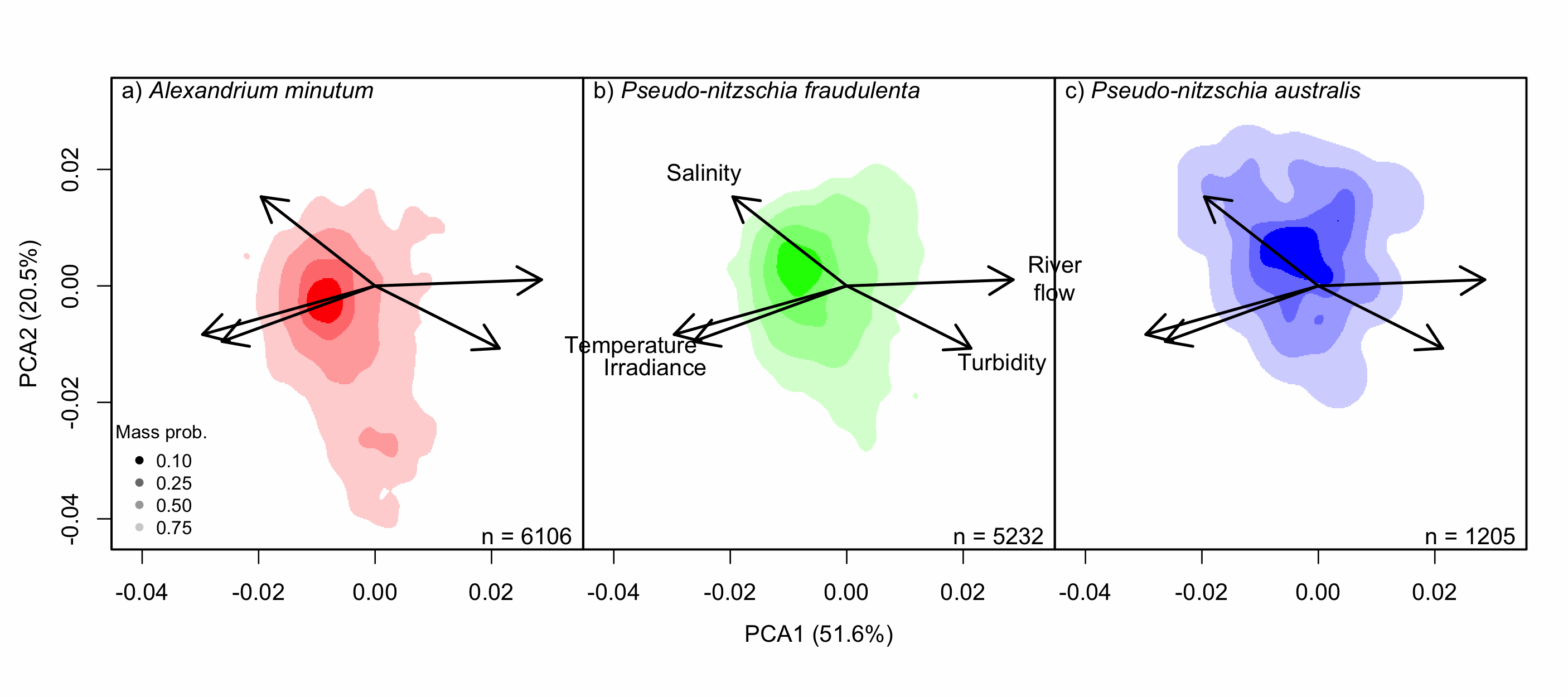
Understanding the spatial and temporal preferences of toxic phytoplankton species is of paramount importance in managing and predicting harmful events in aquatic ecosystems. In this study we address the realised niche of the species Alexandrium minutum, Pseudo-nitzschia fraudulenta and P. australis. We used them to highlight distribution patterns at different scales and determine possible drivers. To achieve this, we have developed original procedures coupling niche theory and habitat suitability modelling using abundance data in four consecutive steps: 1) Estimate the realised niche applying kernel functions. 2) Assess differences between the species’ niche as a whole and at the local level. 3) Develop habitat and temporal suitability models using niche overlap procedures. 4) Explore species temporal and spatial distributions to highlight possible drivers. Data used are species abundance and environmental variables collected over 27 years (1988-2014) and include 139 coastal water sampling sites along the French Atlantic coast. Results show that A. minutum and P. australis niches are very different, although both species have preference for warmer months. They both respond to decadal summer NAO but in the opposite way. P. fraudulenta realised niche lies in between the two other species niches. It also prefers warmer months but does not respond to decadal summer NAO. The Brittany peninsula is now classified as an area of prevalence for the three species. The methodology used here will allow to anticipate species distribution in the event of future environmental challenges resulting from climate change scenarios.