 Catalogue PIGMA
Air temperature
Type of resources
Available actions
Topics
Keywords
Contact for the resource
Provided by
Years
Formats
Representation types
Update frequencies
status
Scale
Resolution
-
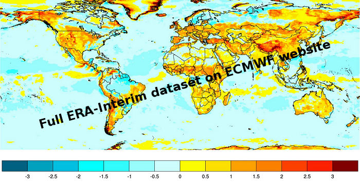
ERA-Interim is a dataset, showing the results of a global climate reanalysis from 1979 to date. ERA-Interim continues to be updated in near-real-time as new data becomes available.
-
The National Centers for Environmental Prediction (NCEP) Climate Forecast System (CFS) is initialized four times per day (0000, 0600, 1200, and 1800 UTC). NCEP upgraded their operational CFS to version 2 on March 30, 2011. This is the same model that was used to create the NCEP Climate Forecast System Reanalysis (CFSR), and the purpose of this dataset is to extend CFSR. The 6-hourly atmospheric, oceanic and land surface analyzed products and forecasts, available at 0.2, 0.5, 1.0, and 2.5 degree horizontal resolutions, are archived here beginning with January 1, 2011 as an extension of CFSR.
-
C-RAID: Comprehensive Reprocessing of Drifting Buoy Data (1979-2018) The C-RAID (Copernicus - Reprocessing of Drifting Buoys) project delivers a comprehensive global reprocessing of historical drifting buoy data and metadata, providing climate-quality observations for marine and atmospheric research. Dataset Overview The C-RAID dataset encompasses metadata from 21 858 drifting buoys deployed between 1979 and 2018. Of these, 17 496 buoys have undergone complete reprocessing with scientific validation in delayed mode, including comparison against ERA5 reanalysis. Project Context Managed by the WMO DBCP Drifting Buoys Global Data Assembly Centre (GDAC) through Ifremer, Météo-France, and Ocean Sciences Division of Fisheries and Oceans Canada, C-RAID focuses on enhanced quality control and delivery of climate-quality drifting buoy data for the Marine Climate Data System (MCDS). Objectives - Complete reprocessing and clean-up of the historical drifting buoy data archive - Recovery and rescue of missing datasets - Reprocessing of Argos data with improved positioning using Kalman filter algorithms - Homogenization of quality control procedures across marine and atmospheric parameters Funding & Governance C-RAID was funded by the Copernicus Programme through the European Environment Agency (Contract # EEA/IDM/15/026/LOT1), supporting cross-cutting coordination activities for the in-situ component of Copernicus Services. Stakeholders & Partnerships The project is led by the DB-GDAC consortium (Ifremer, Météo-France) in collaboration with EUMETNET's E-SURFMAR programme, NOAA AOML, and JCOMMOPS. Key Achievements - Reprocessing of approximately 24 000 buoy-years of observations - Recovery of missing datasets and metadata through data rescue efforts - Implementation of homogeneous, rich metadata and data formats - Enhanced Argos location accuracy using Kalman filter reprocessing - Standardized quality control and validation procedures Data Access & FAIR Principles C-RAID provides FAIR (Findable, Accessible, Interoperable, Reusable) data access through: - Web-based data discovery portal for human users - API services for data discovery, subsetting, and download (machine-to-machine access) Target Users The dataset serves major operational and research programmes including: - Copernicus Climate Change Service (C3S) - Copernicus Marine Environment Monitoring Service (CMEMS) - iQuam (in-situ SST Quality Monitor) - ICOADS (International Comprehensive Ocean-Atmosphere Data Set) - GHRSST (Group for High Resolution Sea Surface Temperature) - ISPD (International Surface Pressure Databank) - ICDC (Integrated Climate Data Center)
-

The MONICAN web page provides access to real-time or archived measurements and operational forecasts of the oceanographic conditions prevailing in the Nazare Canyon area of influence. Near real-time measurements in the Nazare Canyon area are collected hourly by the MONICAN network. This network includes two multi-parametric platforms measuring waves, meteorogical parameters (wind, atmospheric pressure, air temperature and relative humidity), sea surface temperature and (for one of the platforms) water temperature in the upper 200m and currents in the upper 100m. The MONICAN network also integrates two coastal tidal stations providing sea surface level measurements in the ports of Nazare and Peniche , and one coastal meteorological station providing meteorological measurements in the area of Ferrel. The near real-time data is presented in graphical form (namely by combining observations and forecasts) and can be accessed in table form. Forecasts of the wave conditions affecting the coast of Nazare are also included.
-
The CORE-II simulations provide a framework to evaluate ocean model performance, to study mechanisms of ocean phenomena and their variability from seasonal to decadal timescales, to identify forced variability changes, and to develop mechanistic descriptions of observed climate variability and change.
-
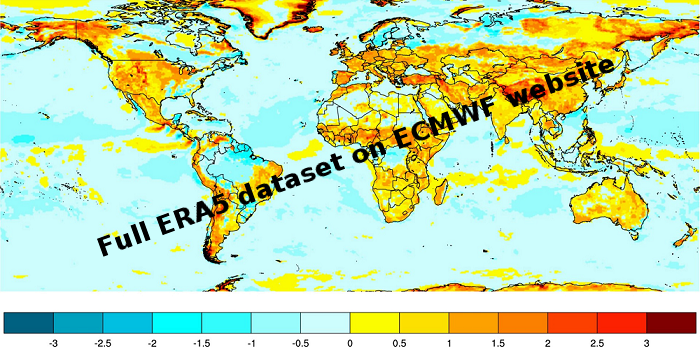
ERA5 is a climate reanalysis dataset, covering the period 1979 to present. ERA5 is being developed through the Copernicus Climate Change Service (C3S). Extracted data available here are one hourly at a regular grid lat,lon 0.25*0.25
-

-

The Global Sea Level Observing System (GLOSS) was established by the Intergovernmental Oceanographic Commission (IOC) of UNESCO in 1985 to establish a well-designed, high-quality in situ sea level observing network to support a broad research and operational user base. Various tide gauge networks have contributed to GLOSS, each with a different focus and each changing over time as research priorities evolve. The main component is the GLOSS Core Network (GCN), a global set of ~300 tide gauges that serves as the backbone of the global in situ sea level network. GCN gauges were allocated to each island or group of islands at intervals not closer than 500 km, and along continental coasts at intervals generally not less than 1000 km. Preference was given to islands in order to maximise exposure to the open ocean. Established in 1933, the Permanent Service for Mean Sea Level (PSMSL) is responsible for the collection, publication, analysis and interpretation of sea level data from the global network of tide gauges, including the GLOSS Core Network.
-

-
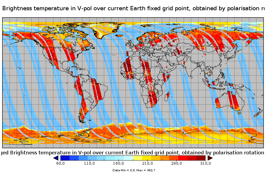
This product is a synthesis product of brightness temperatures for L-Band frequency. It includes all brightness temperatures acquired that very day by the SMOS satellite operating in full pol mode. Values correspond to those at the top of the atmosphere level, transformed to the ground polarisation reference frame, binned and averaged into fixed incidence angle classes. This product is available on each of the EASE2 grid projections (cylindrical and polar).