 Catalogue PIGMA
Atmosphere
Type of resources
Available actions
Topics
Keywords
Contact for the resource
Provided by
Years
Formats
-
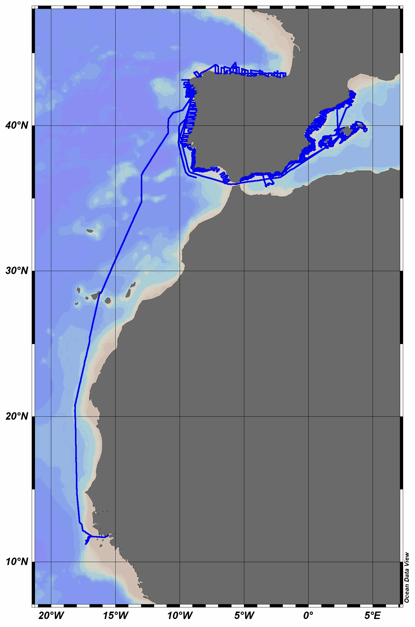
The R/V Miguel Oliver was built in 2007 for scientific fisheries assessment and oceanographic research purposes. Owned by the Spanish General Secretariat of Fisheries, it mainly operates around the Iberian Peninsula and Canary Islands waters. Equipped with an automatic weather station, collected data are daily sent to the Spanish Institute of Oceanography (IEO) Data Center / National Oceanographic Data Center (NODC) for delayed-mode quality control and long-term archive and dissemination. Recently, a semi-automatic process has been used to perform quality control and data assessment. The quality controlled data have been stored in MEDAR/MEDATLAS format, and the corresponding quality flag has been added to each individual measurement. This facilitates their reuse for different purposes, from climatology or academic studies to industrial sector needs, among others. In 2023, air temperature, relative humidity, wind speed and direction and solar radiation were collected.
-
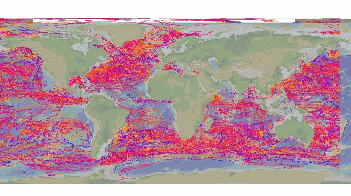
The DBCP – Data Buoy Cooperation Panel - is an international program coordinating the use of autonomous data buoys to observe atmospheric and oceanographic conditions, over ocean areas where few other measurements are taken. DBCP coordinates the global array of 1 600 active drifting buoys (August 2020) and historical observation from 14 000 drifting buoys. Data and metadata collected by drifting buoys are publically available in near real-time via the Global Data Assembly Centers (GDACs) in Coriolis-Ifremer (France) and MEDS (Canada) after an automated quality control (QC). In long term, scientifically quality controlled delayed mode data will be distributed on the GDACs. Disclaimer: the DB-GDAC is under construction. It is currently (January 2020) aggregating data from the Coriolis DAC (E-Surfmar, Canada). Additional DACs are considered. An interim provision from GTS real-time data to GDAC may be provided from Coriolis DAC.
-

C-RAID: Comprehensive Reprocessing of Drifting Buoy Data (1979-2018) The C-RAID (Copernicus - Reprocessing of Drifting Buoys) project delivers a comprehensive global reprocessing of historical drifting buoy data and metadata, providing climate-quality observations for marine and atmospheric research. Dataset Overview The C-RAID dataset encompasses metadata from 21 858 drifting buoys deployed between 1979 and 2018. Of these, 17 496 buoys have undergone complete reprocessing with scientific validation in delayed mode, including comparison against ERA5 reanalysis. Project Context Managed by the WMO DBCP Drifting Buoys Global Data Assembly Centre (GDAC) through Ifremer, Météo-France, and Ocean Sciences Division of Fisheries and Oceans Canada, C-RAID focuses on enhanced quality control and delivery of climate-quality drifting buoy data for the Marine Climate Data System (MCDS). Objectives - Complete reprocessing and clean-up of the historical drifting buoy data archive - Recovery and rescue of missing datasets - Reprocessing of Argos data with improved positioning using Kalman filter algorithms - Homogenization of quality control procedures across marine and atmospheric parameters Funding & Governance C-RAID was funded by the Copernicus Programme through the European Environment Agency (Contract # EEA/IDM/15/026/LOT1), supporting cross-cutting coordination activities for the in-situ component of Copernicus Services. Stakeholders & Partnerships The project is led by the DB-GDAC consortium (Ifremer, Météo-France) in collaboration with EUMETNET's E-SURFMAR programme, NOAA AOML, and JCOMMOPS. Key Achievements - Reprocessing of approximately 24 000 buoy-years of observations - Recovery of missing datasets and metadata through data rescue efforts - Implementation of homogeneous, rich metadata and data formats - Enhanced Argos location accuracy using Kalman filter reprocessing - Standardized quality control and validation procedures Data Access & FAIR Principles C-RAID provides FAIR (Findable, Accessible, Interoperable, Reusable) data access through: - Web-based data discovery portal for human users - API services for data discovery, subsetting, and download (machine-to-machine access) Target Users The dataset serves major operational and research programmes including: - Copernicus Climate Change Service (C3S) - Copernicus Marine Environment Monitoring Service (CMEMS) - iQuam (in-situ SST Quality Monitor) - ICOADS (International Comprehensive Ocean-Atmosphere Data Set) - GHRSST (Group for High Resolution Sea Surface Temperature) - ISPD (International Surface Pressure Databank) - ICDC (Integrated Climate Data Center)
-
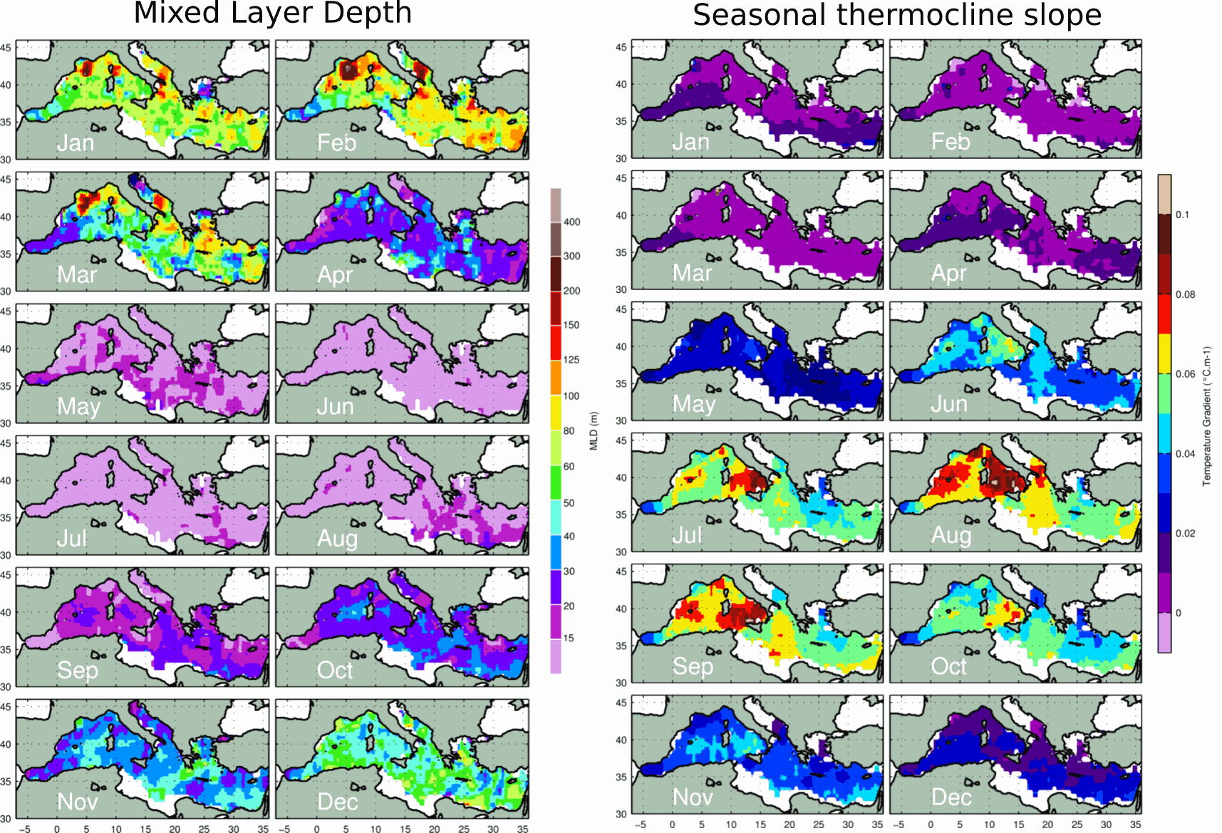
These monthly gridded climatology were produced using MBT, XBT, Profiling floats, Gliders, and ship-based CTD data from different database and carried out in the Med. between 1969 and 2013. The Mixed Layer Depth (MLD) is calculated with a delta T= 0.1 C criterion relative to 10m reference level on individual profiles. The Depth of the Bottom of the Seasonal Thermocline (DBST) is calculated on individual profiles as the maximum value from a vector composed of two elements: 1) the depth of the temperature minimum in the upper 200m; 2) the MLD. This double criterion for the calculation of DBST is necessary in areas where the mixed layer exceed 200m depth. DBST is the integration depth used in the calculation of the upper-ocean Heat Storage Rate. For more details about the data and the methods used, see: Houpert et al. 2015, Seasonal cycle of the mixed layer, the seasonal thermocline and the upper-ocean heat storage rate in the Mediterranean Sea derived from observations, Progress in Oceanography, http://doi.org/10.1016/j.pocean.2014.11.004