 Catalogue PIGMA
Dissolved oxygen
Type of resources
Available actions
Topics
Keywords
Contact for the resource
Provided by
Years
Formats
Representation types
Update frequencies
status
Scale
-
Measurements by drifting surface buoys. This system is a drifting mooring consisting of a surface buoy fastened to a floating anchor by a cable (trip line, buoy rope). It has to monitor as precisely as possible the water volume in which the floating anchor is immersed. The surface buoys are traced by Argos satellites.
-
This In Situ delayed mode product integrates the best available version of in situ oxygen, chlorophyll / fluorescence and nutrients data. The latest version of Copernicus delayed-mode BGC (bio-geo-chemical) product is also distributed from Copernicus Marine catalogue.
-
This product contains observations and gridded files from two up-to-date carbon and biogeochemistry community data products: Surface Ocean Carbon ATlas SOCATv2023 and GLobal Ocean Data Analysis Project GLODAPv2.2023. The SOCATv2023-OBS dataset contains >25 million observations of fugacity of CO2 of the surface global ocean from 1957 to early 2023. The quality control procedures are described in Bakker et al. (2016). These observations form the basis of the gridded products included in SOCATv2023-GRIDDED: monthly, yearly and decadal averages of fCO2 over a 1x1 degree grid over the global ocean, and a 0.25x0.25 degree, monthly average for the coastal ocean. GLODAPv2.2023-OBS contains >1 million observations from individual seawater samples of temperature, salinity, oxygen, nutrients, dissolved inorganic carbon, total alkalinity and pH from 1972 to 2021. These data were subjected to an extensive quality control and bias correction described in Olsen et al. (2020). GLODAPv2-GRIDDED contains global climatologies for temperature, salinity, oxygen, nitrate, phosphate, silicate, dissolved inorganic carbon, total alkalinity and pH over a 1x1 degree horizontal grid and 33 standard depths using the observations from the previous major iteration of GLODAP, GLODAPv2. SOCAT and GLODAP are based on community, largely volunteer efforts, and the data providers will appreciate that those who use the data cite the corresponding articles (see References below) in order to support future sustainability of the data products.
-
CTD data collected during the French oceanographic cruises or joint programs.
-
Bottle samples measurements collected during the French hydrological cruises or during joint experiments.
-
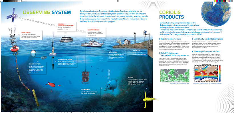
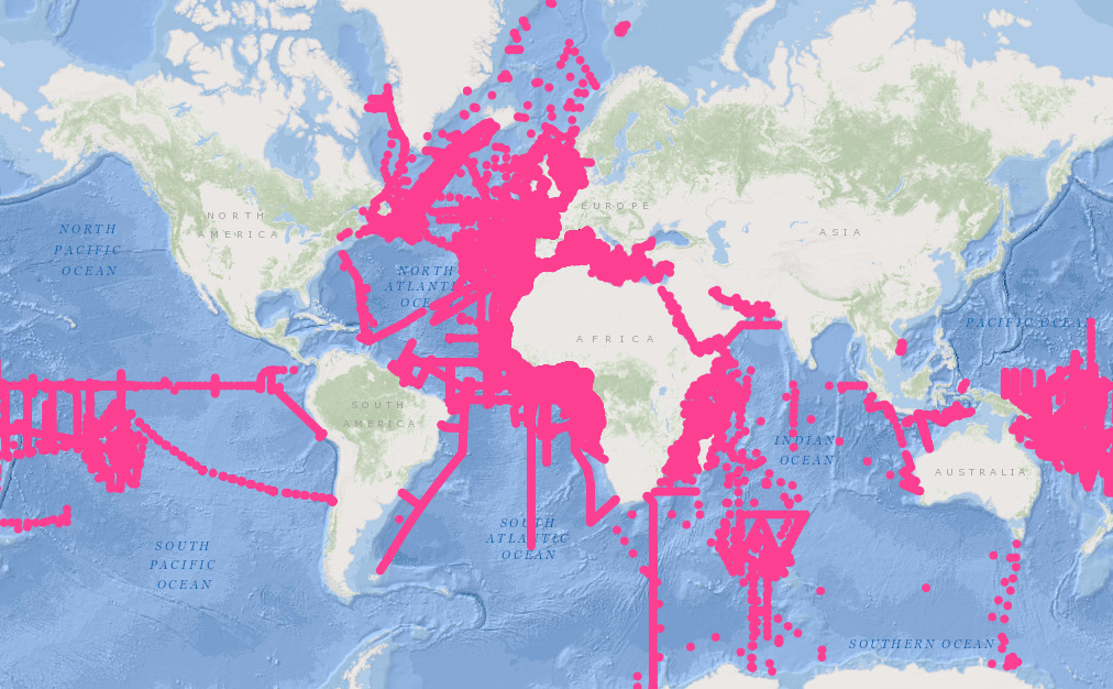
The CORIOLIS data center contributes to the “in situ observations” of operational oceanography, in addition to ocean surface measurements performed using equipment installed on satellites. This contribution is accomplished through the creation of permanent and lasting networks from ships or moored or drifting autonomous systems.
-
The MAGEST observation network aims to continuously monitor the physico-chemical quality of the waters of the estuaries of Northern Aquitaine. In 2023, this regional network is composed of 12 stations.
-
From 2015 to 2018 five field experiments (9 legs) have been performed in the Western Mediterranean Basin during winter or early spring. Thanks to the intensive use of a towed vehicle undulating in the upper oceanic layer between 0 and 400 meter depth (i.e. a Seasoar), a large amount of very high resolution hydrographic transects have been performed, to measure the mesoscale dynamics (slope current and its instabilities, anticyclonic eddies, sub-mesoscale coherent vortices, frontal dynamics convection events, strait outflows) and sub-mesoscale processes like stirring, mixed layer or symmetric instabilities. When available, the data were completed with velocities recorded by Vessel Mounted Acoustic Doppler Current Profiler (VMADCP) and by surface salinity and temperature recorded by ThermosalinoGraph (TSG). Some CTD casts have also been performed giving the background hydrography of the deep layers. In 2017, a Moving Vessel Profiler (MVP) has been deployed to manage even higher horizontal resolution. This data set is an unprecedented opportunity to investigate the very fine scale processes as the Mediterranean Sea is known for its intense and contrasted dynamics. It should be useful for modellers (who reduce the grid size below a few hundred meters) and expect to properly catch finer scale dynamics. Likewise, theoretical work could also be illustrated by in situ evidence embedded in this data set.
-
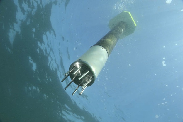
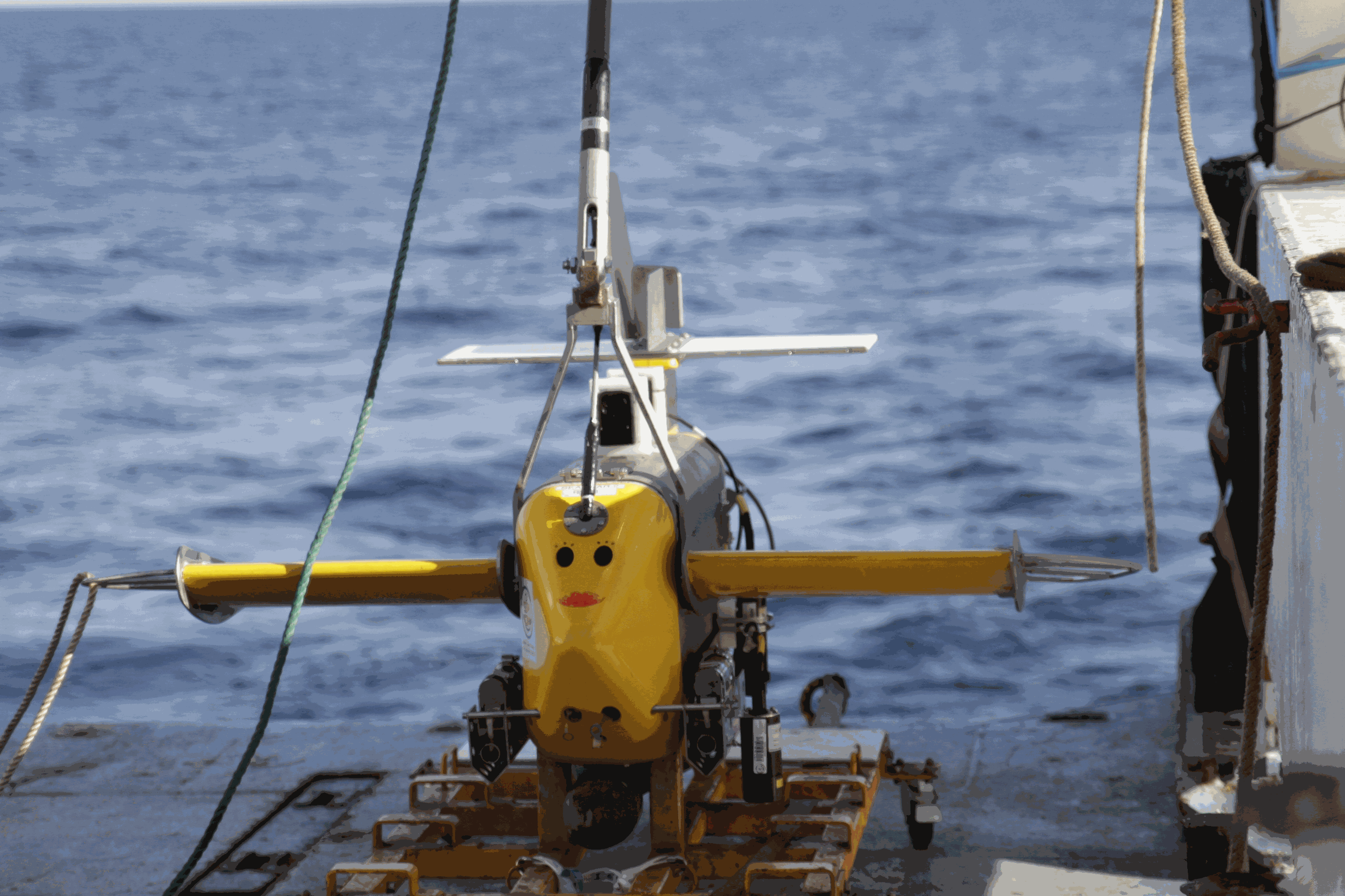
ARVOR-C is a subsurface profiling float designed to operate in coastal environments and to perform oceanographic measurements like a moored installation. Its design has been improved to reduce its drift thanks to a seabed claw and anti-drift claws, an optimized profile speed (~ 25 cm / s) and a short-period data transmission. It is able to process more than 300 profiles and real-time data transmission via Iridium satellite system.
-
This dataset is an aggregation of all availale in situ data from Coriolis and Copernicus in situ data centres, observed in the French DCSMM area. It contains 5167 NetCDF CF files from 1903 to 2017. Each file contains the observations of a specific platform (e.g. vessel, mooring site, sea level station). Observed parameters are temperature, salinity, pressure, oxygen, nitrate, chlorophyll (and other bio-geo-chemicals), current, wave, sea level, river flow.