 Catalogue PIGMA
Geology
Type of resources
Available actions
Topics
Keywords
Contact for the resource
Provided by
Years
Formats
Representation types
Update frequencies
status
Scale
Resolution
-

Distribution of three geomorphologic features (fracture zones, canyons, and seamounts) on the North Atlantic (18°N to 76°N and 36°E to 98°W). Source vector data originated from the GEBCO Gazetteer of Undersea Features Names for fractures, Harris & Whiteway (2011) for canyons, and Yesson et al. (2011) for seamounts. The presence (value=1) of fracture zones or seamounts and the total length of canyons (in km, independently for shelf-incising or blind canyons) was extracted in 25km * 25km gridsquares. This dataset was built to feed a basin-wide spatial conservation planning exercise, targeting the deep sea of the North Atlantic. The goal of this approach was to identify conservation priority areas for Vulnerable Marine Ecosystems (VMEs) and deep fish species, based on the distribution of species and habitats, human activities and current spatial management.
-
Specification of the desirable and recommended product attributes for sediment mass budget at the coast for the last 10, 50 and 100 years for the Mediterranean basin and for each NUTS3 region along the coast.
-
Landslides and gravitational features mapped within French metropolitan EEZ at 1 : 250 000 in the framework of work-package 6 (Geological Events and Probabilities) of the european project EMODNet Geology. These datasets were delivered during the phase 2 of the project.
-

Aggregates map at 1 : 100 000 of the French metropolitan EEZ produced in the work-package 5 (coastline behavior) of the European project EMODnet Geology. This version of the dataset corresponds to the phase III of the project.
-

Geomorphologic map at 1 : 500 000 of the French metropolitan EEZ produced in the work-package 4 (sea-floor geology / geomorphology) of the European project EMODnet Geology. This version of the dataset corresponds to the phase IV of the project.
-

Map of the sedimentation rates within the French metropolitan EEZ produced in the work-package 3 (seabed substrate) of the European project EMODnet Geology. This version of the dataset corresponds to the phase III of the project.
-
Sediment substrate maps at different scales, of the French metropolitan EEZ produced in the work-package 3 the European project EMODNet Geology (phase IV). Available scales : - 1 : 1 000 000 - 1 : 250 000 - 1 : 100 000 - 1 : 50 000 - 1 : 20 000 - 1 : 15 000 - 1 : 10 000 - 1 : 5 000 Bibliographic references : - Coltman, N., Gilliland, P. & van Heteren, S. 2007. What can I do with my map? In: MESH Guide to Habitat Mapping, MESH Project, 2007, JNCC, Peterborough. Available online at: (http://www.searchmesh.net/default.aspx?page=1900) - Foster-Smith, R., Connor, D. & Davies, J. 2007. What is habitat mapping? In: MESH Guide to Habitat Mapping, MESH Project, 2007, JNCC, Peterborough. Available online at: (http://www.searchmesh.net/default.aspx?page=1900) - Väänänen, T. (ed), Hyvönen, E., Jakonen, M., Kupila, J., Lerrsi, J., Leskinen, J., Liwata, P., Nevalainen, R., Putkinen, S., Virkki, H. 2007. Maaperän yleiskartan tulkinta- ja kartoitusprosessi. Maaperän yleiskartoitus –hankkeen sisäinen raportti. 17 p.
-

Physiographic domains map at 1 : 500 000 of the French metropolitan EEZ produced in the work-package 4 (sea-floor geology / geomorphology) of the European project EMODnet Geology. This version of the dataset corresponds to the phase IV of the project.
-
Aggregates map at 1 : 250 000 of the French metropolitan EEZ produced in the work-package 7 (marine minerals) of the European project EMODnet Geology. This version of the dataset corresponds to the phase IV of the project.
-
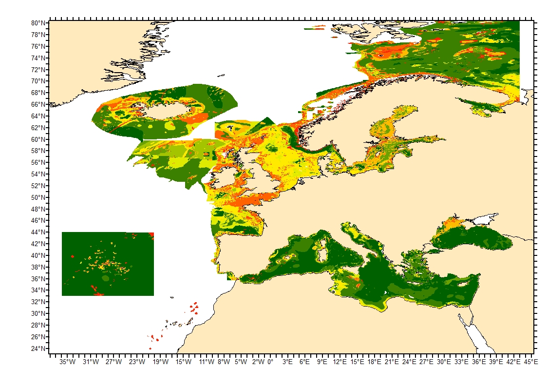
Sediment average grain size in the European North-East Atlantic and Mediterranean waters was generated from Euseamap 2023 sediment categories. This rough granulometry estimate may be used for habitat models at meso- and large scale.