 Catalogue PIGMA
Hauteur de la surface de la mer
Type of resources
Available actions
Topics
Keywords
Contact for the resource
Provided by
Years
Formats
Representation types
Update frequencies
status
Scale
Resolution
-
Monomission altimeter satellite along-track sea surface heights computed with respect to a twenty-year mean. Previously distributed by Aviso+, no change in the scientific content. All the missions are homogenized with respect to a reference mission which is currently OSTM/Jason-2. The sla is computed with an optimal and centered computation time window (6 weeks before and after the date). Two kinds of datasets are proposed: filtered (nominal dataset) and unfiltered.
-
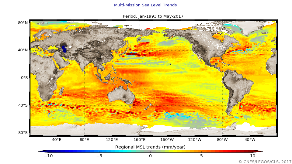
Multimission altimeter satellite gridded sea surface heights and derived variables computed with respect to a twenty-year mean. Previously distributed by Aviso+, no change in the scientific content. All the missions are homogenized with respect to a reference mission. The acquisition of various altimeter data is a few days at most. The sla is computed with a non-centered computation time window (6 weeks before the date).
-

These gridded products are produced from the along-track (or Level-3) SEA LEVEL products (DOI: doi.org/10.48670/moi-00147) delivered by the Copernicus Marine Service (CMEMS, marine.copernicus.eu) for satellites SARAL/AltiKa, Cryosat-2, HaiYang-2B, Jason-3, Copernicus Sentinel-3A&B, Sentinel 6A, SWOT nadir, and SWOT Level-3 KaRIn sea level products (DOI: https://doi.org/10.24400/527896/A01-2023.018). Three mapping algorithms are proposed: MIOST, 4DvarNET, 4DvarQG: - the MIOST approach which give the global SSH solutions: the MIOST method is able of accounting for various modes of variability of the ocean surface topography (e.g., geostrophic, barotrope, equatorial waves dynamic …) by constructing several independent components within an assumed covariance model. - the 4DvarNET approach for the regional SSH solutions: the 4DvarNET mapping algorithm is a data-driven approach combining a data assimilation scheme associated with a deep learning framework. - the 4DvarQG approach for the regional SSH solutions: the 4DvarQG mapping technique integrates a 4-Dimensional variational (4DVAR) scheme with a Quasi-Geostrophic (QG) model. References: - Ballarotta, M., Ubelmann, C., Bellemin-Laponnaz, V., Le Guillou, F., Meda, G., Anadon, C., Laloue, A., Delepoulle, A., Faugère, Y., Pujol, M.-I., Fablet, R., and Dibarboure, G., 2024: Integrating wide swath altimetry data into Level-4 multi-mission maps, EGUsphere [preprint], https://doi.org/10.5194/egusphere-2024-2345 - Beauchamp, M., Febvre, Q., Georgenthum, H., and Fablet, R., 2023: 4DVarNet-SSH: end-to-end learning of variational interpolation schemes for nadir and wide-swath satellite altimetry, Geosci. Model Dev., 16, 2119–2147, https://doi.org/10.5194/gmd-16-2119-2023 - Fablet, R., Beauchamp, M., Drumetz, L., and Rousseau, F., 2021: Joint Interpolation and Representation Learning for Irregularly Sampled Satellite-Derived Geophysical Fields, Front. Appl. Math. Stat., 7, 655224, https://doi.org/10.3389/fams.2021.655224 - Le Guillou, F., Metref, S., Cosme, E., Ubelmann, C., Ballarotta, M. Le Sommer, J. Verron, J., 2021: Mapping Altimetry in the Forthcoming SWOT Era by Back-and-Forth Nudging a One-Layer Quasigeostrophic Model, J. Atmos. Oceanic Technol., 38, 697–710, https://doi.org/10.1175/JTECH-D-20-0104.1 - Ubelmann, C., Dibarboure, G., Gaultier, L., Ponte, A., Ardhuin, F., Ballarotta, M., & Faugère, Y., 2021: Reconstructing ocean surface current combining altimetry and future spaceborne Doppler data. Journal of Geophysical Research: Oceans, 126, e2020JC016560. https://doi.org/10.1029/2020JC016560
-

GDR L2 from US Navy augmented by CTOH with new corrections or parameters
-

Product of simulated SWOT sea surface heights from its 2 altimeters: KaRIn interferometric altimeter and Nadir altimeter. This product includes the Level-2 Low Rate (LR) data (L2_LR_SSH) designed for ocean surfaces and Level-2 and Level-3 SSH corrected by estimations of simulated errors.
-
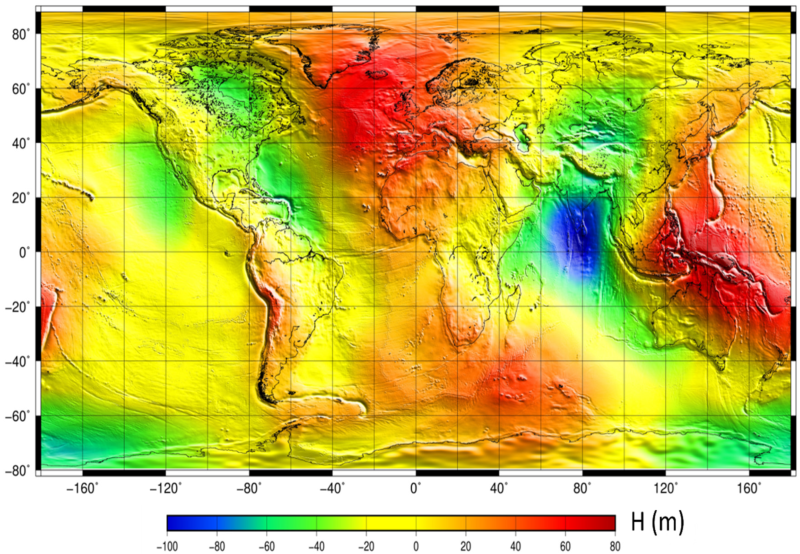
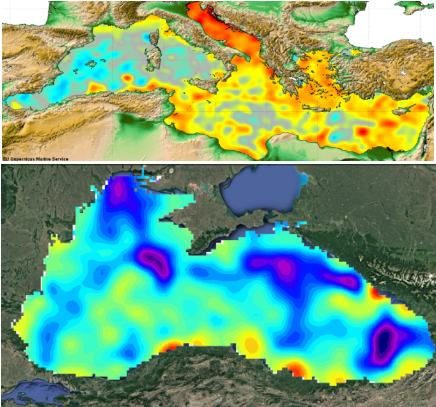
The mean sea surface (MSS) is an important field in physical oceanography, geophysics, and geodesy. In principle, it corresponds to the time-averaged height of the ocean surface. Auxiliary product : mean sea profile above a reference ellipsoid (T/P or WSG84). This surface is available on a regular grid (1/60°x1/60°, 1 minute). Another grid provides the estimation of error fields which represent the MSS accuracy estimated through the inverse technique.
-

Barystatic and manometric sea level changes represent the mass component of sea level changes at global and regional scales respectively. Barystatic and manometric sea level changes are estimated here using the sea level budget approach combining satellite altimetry with in situ measurements of the seawater temperature and salinity. This sea level budget approach is adapted from Barnoud et al., (2023). Two products are distributed over the January 1993 to December 2020 period: - Barystatic sea level changes from sea level budget with uncertainties at 1-sigma: monthly time series, - Manometric sea level changes from sea level budget with uncertainties at 1-sigma: monthly grids with 1 degree spacing.
-
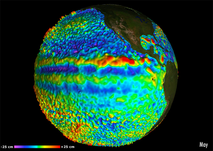
Multimission altimeter satellite gridded sea surface heights and derived variables computed with respect to a twenty-year mean. Previously distributed by Aviso+, no change in the scientific content. All the missions are homogenized with respect to a reference mission. The acquisition of various altimeter data is a few days at most. The sla is computed with a non-centered computation time window (6 weeks before the date).
-
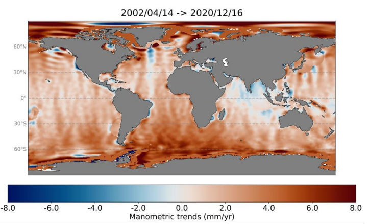
Barystatic and manometric sea level changes represent the mass component of sea level changes at global and regional scales respectively. Barystatic and manometric sea level changes are estimated here using the satellite gravimetry measurements from the GRACE and GRACE-FO missions. Two products are distributed over the April 2002 to August 2022 period: - Barystatic sea level changes from satellite gravimetry with uncertainties at 1-sigma: monthly time series, - Manometric sea level changes from satellite gravimetry with uncertainties at 1-sigma: monthly grids with 1x1 degree.
-
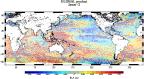
The global mean level of the oceans is one of the most important indicators of climate change. It incorporates the reactions from several different components of the climate system. Precise monitoring of changes in the mean level of the oceans, particularly through the use of altimetry satellites, is vitally important, for understanding not just the climate but also the socioeconomic consequences of any rise in sea level.