Level 2
Type of resources
Available actions
Topics
Keywords
Contact for the resource
Provided by
Years
Formats
Representation types
Update frequencies
-

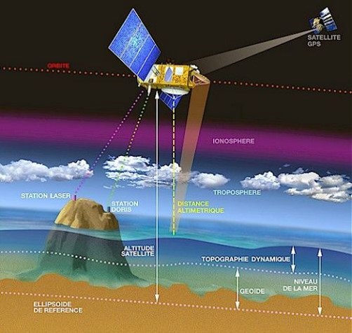
Monomission altimeter product: OSTM/Jason-2. These products were produced by CLS in the framework of the Pistach project, funded by Cnes.
-

Monomission Sentinel-3A altimetry product, LR-RMC mode (Low-Resolution with Range Migration Correction) with along-track level-2 estimations at 20Hz rate in LR-RMC mode. LR-RMC associated waveforms are also included, as well with the geophysical corrections applied to the altimeter range (SGDR files).
-

Along-track altimetric measurements averaged over 1 second, geophysical and environmental corrections to apply. Available missions are: Topex/Poseidon, Envisat, Jason-1, Jason2, Jason-3, Saral and SWOT.
-

'''Short description:''' These products integrate wave observations aggregated and validated from the Regional EuroGOOS consortium (Arctic-ROOS, BOOS, NOOS, IBI-ROOS, MONGOOS) and Black Sea GOOS as well as from National Data Centers (NODCs) and JCOMM global systems (OceanSITES, DBCP) and the Global telecommunication system (GTS) used by the Met Offices. '''DOI (product) :''' https://doi.org/10.17882/70345
-

'''Short description:''' For the Global Ocean- In-situ observation delivered in delayed mode. This In Situ delayed mode product integrates the best available version of in situ oxygen, chlorophyll / fluorescence and nutrients data. '''DOI (product) :''' https://doi.org/10.17882/86207
-
Wave products from french SWIM instrument (height, direction, wavelength) and wind products from chinese SCAT scatterometer (wind speed and direction) on CFOSAT mission. Some meteorological variables sampled at the location of SWIM acquisitions are also distributed in dedicated files.
-

'''This product has been archived''' For operationnal and online products, please visit https://marine.copernicus.eu '''Short description :''' Global Ocean - This delayed mode product designed for reanalysis purposes integrates the best available version of in situ data for ocean surface currents and current vertical profiles. It concerns three delayed time datasets dedicated to near-surface currents measurements coming from two platforms (Lagrangian surface drifters and High Frequency radars) and velocity profiles within the water column coming from the Acoustic Doppler Current Profiler (ADCP, vessel mounted only) platform '''DOI (product) :''' https://doi.org/10.17882/86236
-

"'Short description: ''' Global Ocean - This delayed mode product designed for reanalysis purposes integrates the best available version of in situ data for ocean surface and subsurface currents. Current data from 5 different types of instruments are distributed: * The drifter's near-surface velocities computed from their position measurements. In addition, a wind slippage correction is provided from 1993. Information on the presence of the drogue of the drifters is also provided. * The near-surface zonal and meridional total velocities, and near-surface radial velocities, measured by High Frequency (HF) radars that are part of the European HF radar Network. These data are delivered together with standard deviation of near-surface zonal and meridional raw velocities, Geometrical Dilution of Precision (GDOP), quality flags and metadata. * The zonal and meridional velocities, at parking depth (mostly around 1000m) and at the surface, calculated along the trajectories of the floats which are part of the Argo Program. * The velocity profiles within the water column coming from Acoustic Doppler Current Profiler (vessel mounted ADCP, Moored ADCP, saildrones) platforms * The near-surface and subsurface velocities calculated from gliders (autonomous underwater vehicle) trajectories '''DOI (product) :''' https://doi.org/10.17882/86236
-

'''Short description:''' For the Global Ocean- In-situ observation yearly delivery in delayed mode. The In Situ delayed mode product designed for reanalysis purposes integrates the best available version of in situ data for temperature and salinity measurements. These data are collected from main global networks (Argo, GOSUD, OceanSITES, World Ocean Database) completed by European data provided by EUROGOOS regional systems and national system by the regional INS TAC components. It is updated on a yearly basis. This version is a merged product between the previous verion of CORA and EN4 distributed by the Met Office for the period 1950-1990. '''DOI (product) :''' https://doi.org/10.17882/46219
-

'''Short description:''' For the Global Ocean- In-situ observation yearly delivery in delayed mode. The In Situ delayed mode product designed for reanalysis purposes integrates the best available version of in situ data for temperature and salinity measurements. These data are collected from main global networks (Argo, GOSUD, OceanSITES, World Ocean Database) completed by European data provided by EUROGOOS regional systems and national system by the regional INS TAC components. It is updated on a yearly basis. The time coverage has been extended in the past by integration of EN4 data for the period 1950-1990. Acces through CMEMS Catalogue after registration: http://marine.copernicus.eu/ '''Detailed description: ''' Ocean circulation models need information on the interior of the ocean to be able to generate accurate forecast. This information is only available from in-situ measurement. However this information is acquired all around the world and not easily available to the operational users. Therefore, INS TAC , by connecting to a lot of international networks, collects, controls and disseminates the relevant in-situ data to operational users . For reanalysis purposes, operational centres needs to access to the best available datasets with the best possible coverage and where additional quality control procedures have been performed. This dataset suits research community needs Each year, a new release of this product is issued containing all the observations gathered by the INS TAC global component operated by Coriolis. '''Processing information:''' From the near real time INS TAC product validated on a daily and weekly basis for forecasting purposes, a scientifically validated product is created . It s a ""reference product"" updated on a yearly basis. This product has been controlled using an objective analysis (statistical tests) method and a visual quality control (QC). This QC procedure has been developed with the main objective to improve the quality of the dataset to the level required by the climate application and the physical ocean re-analysis activities. It provides T and S weekly gridded fields and individual profiles both on their original level and interpolated level. The measured parameters, depending on the data source, are : temperature, salinity. The reference level of measurements is immersion (in meters) or pressure (in decibars). The EN4 data were converted to the CORA NetCDF format without any additional validation. '''Quality/accuracy/calibration information:''' The process is done in two steps using two different time windows, corresponding to two runs of objective analysis, with an additional visual QC inserted between. The first run was done on a window of three weeks, to capture the most doubtful profiles which were then checked visually by an operator to decide whether or not it was bad data or real oceanic phenomena. The second run was done on a weekly basis to fit the modelling needs. '''Suitability, Expected type of users / uses: ''' The product is designed for assimilation into operational models operated by ocean forecasting centres for reanalysis purposes or for research community. These users need data aggregated and quality controlled in a reliable and documented manner.
 Catalogue PIGMA