 Catalogue PIGMA
Spatial data products
Type of resources
Available actions
Topics
Keywords
Contact for the resource
Provided by
Years
Formats
Representation types
Update frequencies
status
Scale
Resolution
-
Ireland’s Marine Atlas is developed and maintained by the Marine Institute with funding by the Government of Ireland. This work is part supported by the Irish Government and the European Maritime & Fisheries Fund as part of the EMFF Operational Programme for 2014-2020. The atlas provides a one-stop-shop to view and download marine environmental data relevant to reporting under Ireland’s Marine Strategy Framework Directive (MSFD). The aim of the European Union’s MSFD directive is to protect more effectively the marine environment across Europe through the establishment of “good marine waters”. Data in Ireland’s Marine Atlas has been guided by the European Directive on harmonising environmental data across Europe within a spatial data infrastructure known as INSPIRE. INSPIRE Data Specifications (Data Models) have been used to manage data to the categories visible under THEMES in the atlas. Many of the layers displayed in the Atlas are also used in the National Marine Planning Framework (NMPF). This framework aims to bring together all marine-based human activities, outlining the government’s vision, objectives and marine planning policies for each marine activity. The NMPF report details how these marine activities will interact with each other in an ocean space that is under increasing spatial pressure, ensuring the sustainable use of our marine resources to 2040. Please read the following information carefully as it sets out the terms and conditions that govern the use of products and services on this website. Once you have read these terms and conditions click the "Agree" button at the bottom of the page to proceed. By clicking the "Agree" button you will be deemed to have accepted the terms and conditions, our legal notices and privacy statement.
-

The European Marine Observation and Data Network (EMODnet) is the European Union's in situ marine data service, managed by the European Commission (EC) Directorate-General Maritime Affairs and Fisheries (EC DG MARE) and funded by the European Maritime Fisheries and Aquaculture Fund. Established in 2009, EMODnet plays a pivotal role as a trusted source of in situ marine environmental and human activities data and data products, serving a diverse user base across various sectors. Covering seven disciplinary themes – bathymetry, geology, physics, chemistry, biology, seabed habitats and human activities – EMODnet spans the entire marine environment from coast to open ocean, surface to deep seafloor, whilst also offering data and information on the Blue Economy operations, from vessel density and offshore platform sitings, to hosting EU Member State Maritime Spatial Plans.
-
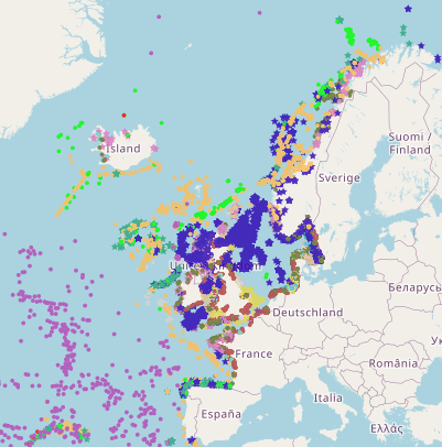
This is a compilation of OSPAR habitat point data for the northeast Atlantic submitted by OSPAR contracting parties. The compilation is coordinated by the UK's Joint Nature Conservation Committee, working with a representative from each of the OSPAR coastal contracting parties. This public dataset does not contain records relating to sensitive species (e.g. Ostrea edulis) in specific areas, or where data are restricted from public release by the owner's use limitations. This version (v2020) was published in July 2021.
-

This layer shows the current known extent and distribution of live hard coral cover in European waters, collated by EMODnet Seabed Habitats. The polygons portion was last updated in 2019. The points were added in Sept 2021. Lophelia pertusa and Coral gardens are both on the OSPAR List of threatened and/or declining species and habitats. The purpose was to produce a data product that would provide the best compilation of evidence for the essential ocean variable (EOV) known as Hard coral cover and composition (sub-variable: Live hard coral cover and extent), as defined by the Global Ocean Observing System (GOOS). This data product should be considered a work in progress and is not an official product.
-
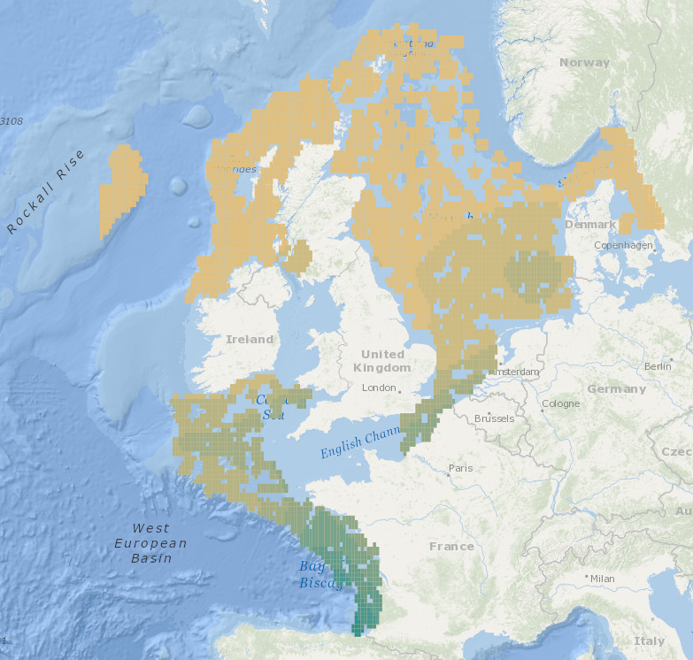
Intermediate Assessment 2017 - Seabed Litter - Litter is widespread on the seafloor across the area assessed, with plastic being the predominant material encountered. In the areas assessed, higher amounts of litter are found in the Eastern Bay of Biscay, Southern Celtic Seas and English Channel relative to the north of the Greater North Sea and Celtic Seas.
-
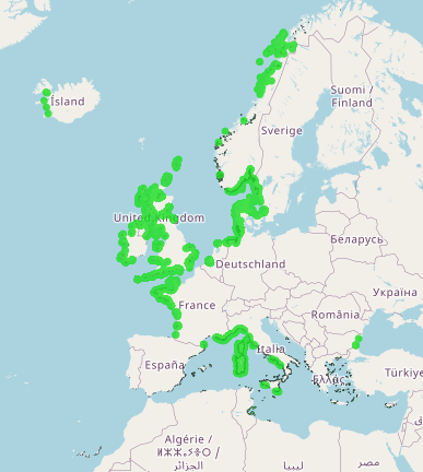
This layer shows the current known extent and distribution of Seagrass meadows in European waters, collated by EMODnet Seabed Habitats. The polygons portion was last updated in 2019. The points were added in Sept 2021. The purpose was to produce a data product that would provide the best compilation of evidence for the essential ocean variable (EOV) known as Seagrass cover and composition (sub-variable: Areal extent of seagrass meadows), as defined by the Global Ocean Observing System (GOOS). Seagrasses provide essential habitat and nursery areas for many marine fauna. There are approximately 72 seagrass species that belong to four major groups: Zosteraceae, Hydrocharitaceae, Posidoniaceae and Cymodoceaceae. Zostera beds and Cymodecea meadows are named on the OSPAR Threatened or Declining Habitats list. Posidonia beds are protected under Annex I of the EU Habitats Directive. This data product should be considered a work in progress and is not an official product.
-
EMODnet Biology provides three keys services and products to users. 1)The data download toolbox allows users to explore available datasets searching by source, geographical area, and/or time period. Datasets can be narrowed down using a taxonomic criteria, whether by species group (e.g. benthos, fish, algae, pigments) or by both scientific and common name. 2) The data catalogue is the easiest way to access nearly 1000 datasets available through EMODnet Biology. Datasets can be filtered by multiple parameters via the advanced search from taxon, to institute, to geographic region. Each of the resulting datasets then links to a detailed fact sheet containing a link to original data provider, recommended citation, policy and other relevant information. Data Products - EMODnet Biology combines different data from datasets with overlapping geographic scope and produces dynamic maps of selected species abundance. The first products are already available and they focus on species whose data records are most complete and span for a longer term.
-
Stakeholder networks from 32 countries united to collaborate on Ocean Action, Climate Action, addressing pollution from land-based, riverine and marine-based sources and advancing Circular Economy development. International Waste Platform provides international expertise and launches joint initiatives; It supports advancing solutions to mitigate the global waste, plastic pollution & climate crises which are interlinked. Representatives committed themselves to align objectives, to support the implementation of strategies of Ocean Action and Climate Action, as well as to share ideas, best practices, concepts, programs, knowledge and opportunities; including the reduction of plastic debris at the source, before it enters rivers and the coastal environment. Country / regional networks and national marine debris networks make a difference in societal behaviour change and environmental policies by providing input and promoting action which aims at finding solutions to reduce (ocean) plastic pollution. Country and regional networks are instrumental to reach the prevention and reduction of marine pollution, facilitate and foster the establishment of national and international partnerships in a multi-stakeholder approach.
-
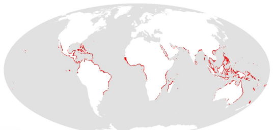
This dataset shows the global distribution of mangroves, and was produced as joint initiatives of the International Tropical Timber Organization (ITTO), International Society for Mangrove Ecosystems (ISME), Food and Agriculture Organization of the United Nations (FAO), UN Environment World Conservation Monitoring Centre (UNEP-WCMC), United Nations Educational, Scientific and Cultural Organization’s Man and the Biosphere Programme (UNESCO-MAB), United Nations University Institute for Water, Environment and Health (UNU-INWEH) and The Nature Conservancy (TNC). Major funding was provided by ITTO through a Japanese Government project grant; the project was implemented by ISME.
-

Portal to view and download observations of Vulnerable Marine Ecosystem (VME) indicators and habitats in the North Atlantic. A central portal for data on the distribution and abundance of Vulnerable Marine Ecosystems (VMEs), (and organisms considered to be indicators of VMEs) across the North Atlantic has been set up by the Joint ICES/NAFO Working Group on Deep-water Ecology (WGDEC). Criteria used to select habitats and indicators for inclusion in the database were those described in the FAO International Guidelines for the Management of Deep-sea Fisheries in the High Seas (FAO, 2009). The database is comprised of: - 'VME habitats' that are records for which there is unequivocal evidence for a VME, e.g. ROV observations of a coral reef - 'VME indicators' which are records that suggest the presence of a VME with varying degrees of uncertainty. For VME indicators a weighting system of vulnerability and uncertainty is provided as part of the database to aid interpretation. The VME database may be used for many purposes. ICES uses it when providing scientifically-robust advice on the distribution of VMEs and recommending possible management solutions such as bottom fishing closures within North East Atlantic Fisheries Commission (NEAFC) waters to protect VMEs.