 Catalogue PIGMA
CNES
Type of resources
Available actions
Topics
Keywords
Contact for the resource
Provided by
Years
Formats
Representation types
status
Resolution
-
Produit altimétrique combiné Ssalto/Duacs des moyennes et climatologies des anomalies de hauteurs de mer. Ces produits sont calculées par rapport à une moyenne sur 20 ans (1993-2012), incluant la variabilité saisonnière (aucun cycle n'est retiré)
-
Produits altimétriques auxiliaires
-
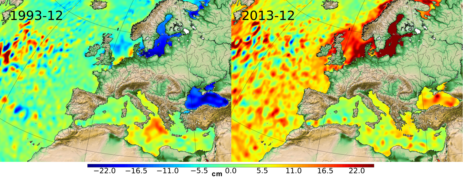
Le niveau moyen global des océans est un des indicateurs les plus importants du réchauffement climatique. Il intègre la réponse de plusieurs composantes du système climatique. Le suivi précis de l'évolution du niveau moyen des océans, grâce notamment aux satellites altimétriques, est d'une importance majeure, non seulement pour la compréhension du climat mais aussi pour les conséquences socio-économiques de son élévation.
-
Produits altimétriques monomissions OSTM/Jason-2. Ces produits ont été produits par CLS dans le cadre du projet Pistach, financé par le Cnes.
-

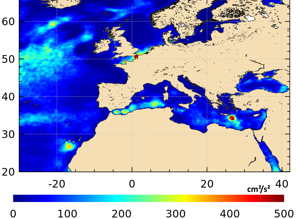
Produit altimétrique combiné Ssalto/Duacs des moyennes mensuelles de l'énergie cinétique des tourbillons (Eddy Kinetic Energy -EKE) dérivés des hauteurs de la surface de la mer (SSH) calculées par rapport à un profil moyen sur vingt ans [1993-2012], et incluant la variabilité saisonnière (NB. le cycle annuel n'est pas supprimé), moyennées mois par mois depuis janvier 1993.
-
Produits altimétriques auxiliaires - élévations de marées, courants de marées, effets de charge dues à la marée
-
Produit altimétrique expérimental Sentinel-3 mode LR-RMC (niveau2, monomission, le long de la trace)

Produit altimétrique monomission Sentinel-3A en mode LR-RMC (Low-Resolution with Range Migration Correction) avec des données le long de la trace de niveau 2 échantillonnées à 20Hz en mode LR-RMC. Les formes d'onde associées au mode LR-RMC sont aussi contenues dans les produits ainsi que les corrections géophysiques appliquées à la distance altimétrique (fichiers SGDR).
-

This Level 2 product provides marine reflectances from the VENµS mission, processed with the Polymer algorithm, on a subset of sites with coastal or inland areas. VENµS (Vegetation and Environment monitoring on a New Micro-Satellite) is a Franco-Israeli satellite launched in 2017, dedicated to the fine and regular monitoring of terrestrial vegetation, in particular cultivated areas, forests, protected natural areas, etc. The images acquired in 12 spectral bands by a camera provided by CNES, on a selection of about one hundred scientific sites spread over the planet, are of high spatial (5 m) and temporal resolution. The lifetime of the VENµS satellite has been divided into two phases: a first phase VM1 at an altitude of 720 km with a 2-day revisit, a native spatial resolution of 5.3 m and a swath of 27.6 km from August 2017 to November 2020, and a second phase VM5 at an altitude of 560 km with a daily revisit, a native spatial resolution of 4.1 m and a swath of 21.3 km from March 2022 to July 2024. VENµS is the first sensor on board an orbiting satellite to combine such revisit frequency and spatial finesse for vegetation monitoring. A subset of sites with coastal areas or inland waters have been identified to generate Level 2 data dedicated to marine reflectance. The geographical areas covered are given through a kmz file, see below to download it. This Level 2 data product has been processed using the Polymer algorithm developed by Hygeos (https://hygeos.com/en/polymer/) and provides marine reflectances for the VENµS bands from 420 to 865 nm. These reflectances, without units, include a bidirectional normalization for the Sun at nadir and the observer at nadir. VENµS data products (Level-1, Level-2 and Level-3) are primarily generated with the MAJA algorithm, further information can be found on THEIA website: https://www.theia-land.fr/en/product/venus/
-
GDR L2 from ESA Baseline-C converted by CTOH into netCDF, splited by ascending/descending pass and augmented of recent corrections