 Catalogue PIGMA
inlandWaters
Type of resources
Available actions
Topics
Keywords
Contact for the resource
Provided by
Years
Formats
Representation types
Update frequencies
status
Scale
Resolution
-

Maisons éclusières sur les départements de la Gironde et du Lot-et-Garonne.
-
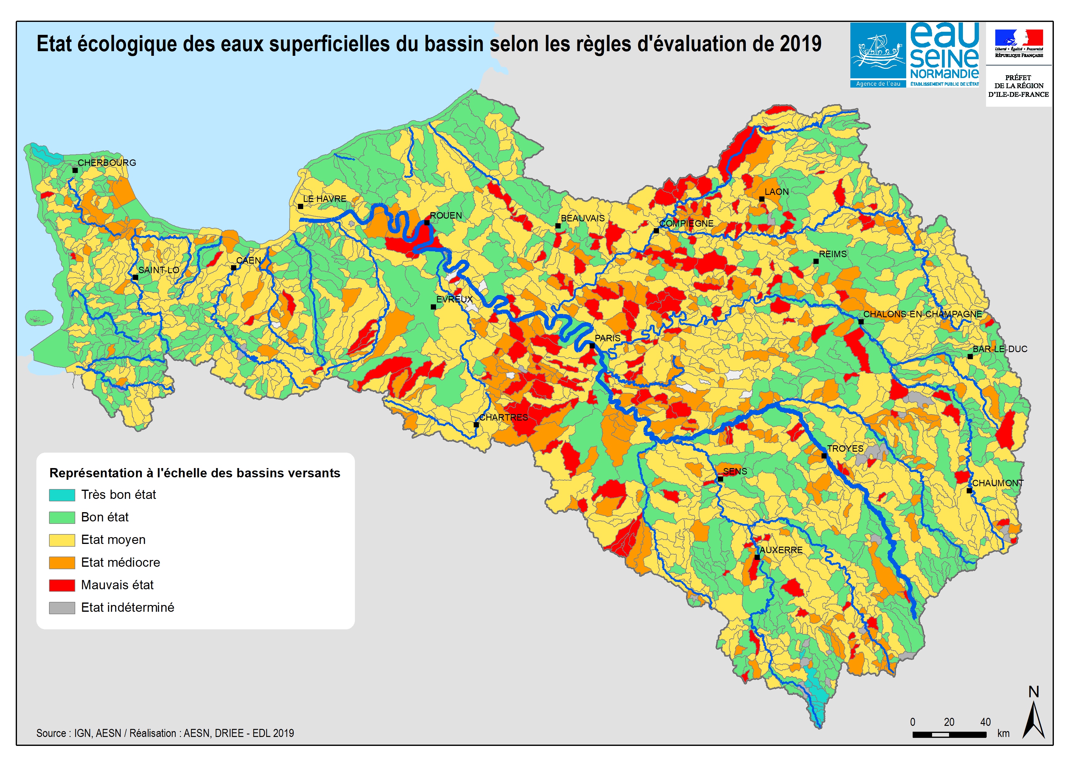
Le référentiel inondation Gironde (RIG) est un outil d’aide à la décision. Il vise à apporter une connaissance précise des caractéristiques morphologiques du territoire et une modélisation hydraulique des principaux phénomènes dynamiques de crue influençant directement les inondations sur l'estuaire de la Gironde. L'objectif est ainsi de permettre à l’ensemble des partenaires d’orienter des études en vue d’améliorer ou d’optimiser la protection et la gestion des zones inondables du territoire. Le RIG, modèle hydraulique, s'appuie sur un jeu important de données (topographie, bathymétrie, digues, ouvrages, foncier, marégrammes, orientation du vent, etc.).
-
-

Centres d'exploitation sur les départements de la Dordogne, Gironde et du Lot-et-Garonne
-
Colloque organise par le Conseil scientifique et culturel du PNR des Landes de Gascogne
-

Ensemble résultant du découpage par zones du chenal de navigation.Ces passes sont régulièrement hydrographiées.
-
A transitional water mass is a discrete and significant element of surface water located near the mouths of rivers or streams, which are partly saline because of their proximity to coastal waters but which are substantially influenced by freshwater currents, constituting the elemental aquatic boundaries destined for the evaluational unit of the DCE. Correspondence DCE reporting: This entity corresponds to the concept of Transitional Water Body (TWBODY) of the WISE.
-

Prises d'eau sur les départements de la Gironde et du Lot-et-Garonne.
-
The territorial organization of flood warning has two components: - The SCHAPI or central service for Hydrometeorology and support for flood forecasting, - 22 services for flood forecasting (SPC), replacing, since 2002, the 52 flood warning services (SAC) existing. The legal framework for flood forecasting is defined in the law relating to natural and technological hazards, adopted on 30 July 2003.
-
A coastal water body is a discrete and significant element of surface water located between the baseline from which to measure the breadth of territorial waters to a distance of one nautical mile. Correspondence reporting of the WFD (Water Framework Directive) : This entity corresponds to the concept of Coastal Water Body (CWBODY) of WISE.