 Catalogue PIGMA
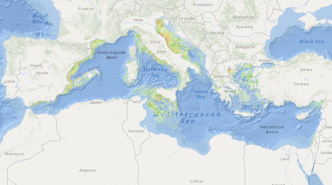
oceans
Type of resources
Available actions
Topics
Keywords
Contact for the resource
Provided by
Years
Formats
Representation types
Update frequencies
status
Scale
Resolution
-
MEDSEA_CH5_Product_7 / Change level of disturbance from AIS data combined with habitat vulnerability
to deliver maps showing the extent of the trawling fishing grounds for identifying the changes in level of disturbance over the past ten years and identifying the gaps of fishing vessels’ tracking systems in the Mediterranean Sea
-
This visualization product displays the location of all the surveys present in the EMODnet marine litter database (MLDB). The different fishing gears used are represented by different colors. EMODnet Chemistry included the collection of marine litter in its 3rd phase. Since the beginning of 2018, data of seafloor litter collected by international fish-trawl surveys have been gathered and processed in the EMODnet Chemistry Marine Litter Database (MLDB). The harmonization of all the data has been the most challenging task considering the heterogeneity of the data sources, sampling protocols (OSPAR and MEDITS protocols) and reference lists used on a European scale. Moreover, within the same protocol, different gear types are deployed during bottom trawl surveys. Unlike other EMODnet seafloor litter products, all trawls surveyed since 2006 are included in this map even if the wingspread and/or the distance are unknown. Only surveys with an unknown number of items were excluded from this product. More information on data processing and calculation are detailed in the attached document. Warning: the absence of data on the map does not necessarily mean that they do not exist, but that no information has been entered in the Marine Litter Database for this area.
-
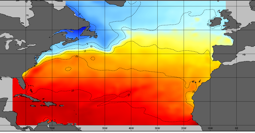
The SDC_NAT_CLIM_TS_V1 product contains Temperature and Salinity Climatologies for the North Atlantic Ocean including the seasonal and monthly fields for period 1955-2015 and seasonal fields for 6 decades starting from 1955 to 2015. Two resolutions have been processed : 1/2° and 1/4°. The climatic fields were computed from the integrated North Atlantic Ocean dataset that combines data extracted from the 2 major sources: SeaDataNet infrastructure and Coriolis Ocean Dataset for Reanalysis (CORA). The computation was done with the DIVA software, version 4.7.2.
-
This product displays the stations present in EMODnet validated dataset where naphthalene levels have been measured in water. EMODnet Chemistry has included the gathering of contaminants data since the beginning of the project in 2009. For the maps for EMODnet Chemistry Phase III, it was requested to plot data per matrix (water,sediment, biota), per biological entity and per chemical substance. The series of relevant map products have been developed according to the criteria D8C1 of the MSFD Directive, specifically focusing on the requirements under the new Commission Decision 2017/848 (17th May 2017). The Commission Decision points to relevant threshold values that are specified in the WFD, as well as relating how these contaminants should be expressed (units and matrix etc.) through the related Directives i.e. Priority substances for Water. EU EQS Directive does not fix any threshold values in sediments. On the contrary Regional Sea Conventions provide some of them, and these values have been taken into account for the development of the visualization products. To produce the maps the following process has been followed: 1. Data collection through SeaDataNet standards (CDI+ODV) 2. Harvesting, harmonization, validation and P01 code decomposition of data 3. SQL query on data sets from point 2 4. Production of map with each point representing at least one record that match the criteria The harmonization of all the data has been the most challenging task considering the heterogeneity of the data sources, sampling protocols. Preliminary processing were necessary to harmonize all the data : • For water: contaminants in the dissolved phase; • For sediment: data on total sediment (regardless of size class) or size class < 2000 μm • For biota: contaminant data will focus on molluscs, on fish (only in the muscle), and on crustaceans • Exclusion of data values equal to 0
-

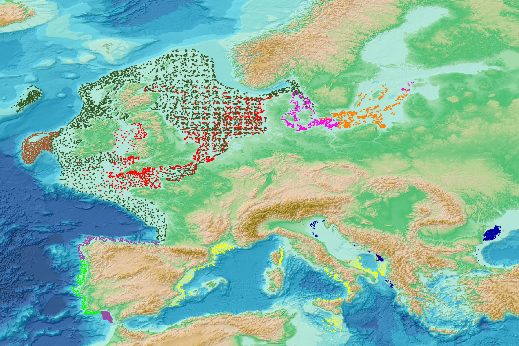
In order to better characterize the genetic diversity of Cetaceans and especially the common Dolphin from the Bay of Biscay, sequences from the variable mitochondrial control region were obtained from water samples acquired close to groups of dolphins.
-

COSYNA (Coastal Observation System for Northern and Arctic Seas) is an operational coastal monitoring, forecasting and information system for the North Sea composed by fixed platforms, FerryBoxes, gliders and HF-radar systems. It is being developed by institutes of the German Marine Research Consortium (KDM) and collaborating institutions and is operated by the HZG Research Centre. The infrastructure represents an investment of 9 M €. It was build up since 2007 and is fully operational since 2012. COSYNA_GL is one of the 2 gliders of the system (TWR Slocum Electric, 100 m) equipped with CTD, Wetlabs ECO puck FLNTU (fluorescence and turbidity) and CDOM fluorescence.
-
This product attempt to follow up on the sea level rise per stretch of coast of the North Atlantic, over past 10 years as follows: • Characterization of absolute sea level trend at annual resolution, along the coasts of EU Member States (including Outermost Regions), Canada, Faroes, Greenland, Iceland, Mexico, Morocco, Norway and USA; The stretchs or coast are defined by the administrative regions of the Atlantic Coast: • from NUTS3** administrative division for EU countries (see Eurostat), and • from GADM*** administrative divisions for non-EU countries. ** Third level of Nomenclature of Territorial Units for Statistics *** Global Administrative Areas For relative sea level trend for 10 years we extract the information from coastal tide gauge data available for each stretch of coast, if no tide gauge available there is a dat gap. The product is Provided in tabular form and as a map layer.
-

'''Short description:''' For the Global - Arctic and Antarctic - Ocean. The OSI SAF delivers five global sea ice products in operational mode: sea ice concentration, sea ice edge, sea ice type (OSI-401, OSI-402, OSI-403, OSI-405 and OSI-408). The sea ice concentration, edge and type products are delivered daily at 10km resolution and the sea ice drift in 62.5km resolution, all in polar stereographic projections covering the Northern Hemisphere and the Southern Hemisphere. The sea ice drift motion vectors have a time-span of 2 days. These are the Sea Ice operational nominal products for the Global Ocean. '''DOI (product) :''' https://doi.org/10.48670/moi-00134
-

-

This is the FAO Fishery and Aquaculture Reference Data repository: Codes and reference data for fishing gear, species, currencies, commodities, countries and others.