 Catalogue PIGMA
transportation
Type of resources
Available actions
Topics
Keywords
Provided by
Years
Formats
Representation types
Update frequencies
status
Scale
Resolution
-
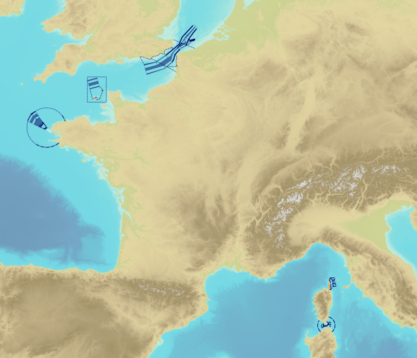
"Traffic Separation Schemes" product contains a description of TSS in French maritime spaces. A TSS is a routeing measure aimed at the separation of opposing streams of traffic by appropriate means and notably by the establishment of traffic lanes. The measures taken aim at improving navigation safety in areas where navigation is threatened by the density of traffic associated with various natural difficulties. Several classes of objects constitute this product, the acronyms used are those of IHO standard S-57: - Traffic separation scheme lane part (TSSLPT): area of a traffic lane in which the direction of flow of traffic is uniform; - Traffic separation scheme boundary (TSSBND): outer limit of a traffic lane part or a traffic separation scheme roundabout; - Traffic separation line (TSELNE): common boundary between two traffic lanes, or between one traffic lane and one inshore traffic zone; - Traffic separation zone (TSEZNE): separation areas between two traffic lanes, or between one traffic lane and one inshore traffic zone, or to the central area of a roundabout; - Inshore traffic zone (ISTZNE): area between the landward boundary of a traffic separation scheme and the adjacent coast; - Precautionary area (PRCARE): area, within defined limits, where ships must navigate with particular caution, and within which the direction of traffic flow may be recommended; - Deep water route part (DWRTPT): sections within which the flow of traffic either follows one defined direction for one-way traffic, or follows one defined direction and its reciprocal for two-way traffic. A deep-water route is a route in a designated area within defined limits which has been accurately surveyed for clearance of sea bottom and submerged obstacles to a minimum indicated depth of water; - Two-way route part (TWRTPT): sections within which traffic flows in two directions along one bearing and its reciprocal. These route parts are generally two-way, but some may be restricted to one-way traffic flow; - Radio calling-in line (RDOCAL_lne) : positions at which vessels are required to report to a traffic control centre.
-

-
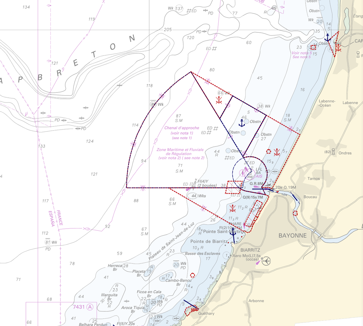
"Regulation - Navigation" product contains 18 object classes, the acronyms used are those of IHO standard S-57 - International Hydrographic Organization – (https://iho.int/): - Anchorage area (ACHARE): an area in which vessels anchor or may anchor. - Anchor berth (ACHBRT): a designated area of water where a single vessel, sea plane, etc. may anchor. - Administration Area (Named) (ADMARE) - Cable area (CBLARE) - Coastguard station (CGUSTA) - Cargo transhipment area (CTSARE) - Distance mark (DISMAR): mark indicating the distance on canals or rivers. - Dumping ground (DMPGRD): sea area where dredged material or other potentially more harmful material e.g. explosives, chemical waste, is deliberately deposited. - Fairway (FAIRWY): part of a river, harbour etc. where the main navigable channel for vessels of larger size lies. It is also the usual course followed by vessels entering or leaving harbours and sometimes called "ship channel". - Ice area (over land or water) (ICEARE) - Local magnetic anomaly (LOCMAG): anomaly of the magnetic field of the earth, extending over a relatively small area, due to local magnetic influences. - Marine farm/culture (MARCUL) - Navigation line (NAVLNE): a line generally passing through two clearly defined charted landmarks, and along part of which a vessel can approach safely. - Pipeline area (PIPARE) - Recommended track (RECTRC): track of undefined width, recommended to all or only certain vessels. - Restricted area (RESARE): specified area designated by an appropriate authority within which navigation is restricted in accordance with certain specified conditions. - Sea-plane landing area (SPLARE) Detailed definitions of each of these object classes can be found in the S-57 standard (https://iho.int/en/standards-and-specifications). An online catalog is available at http://www.s-57.com/. Some of the symbols used for display on data.shom.fr portal have been adapted from icons from the OpenSeaMap open library (https://github.com/OpenNauticalChart/). For reasons of readability, not all the characteristics of the objects are systematically displayed. All available information can be consulted by querying this layer.
-

-

-
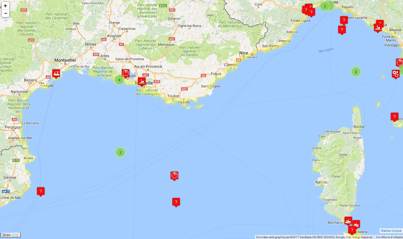
Données historiques des accidents en mer Méditerranée (depuis 1977) intégrées dans le Système d'information géographique intégré méditerranéen pour l'évaluation du risque et la lutte contre la pollution (MEDGIS-MAR) géré par le Centre Régional Méditerranéen pour l’Intervention d’Urgence Contre la Pollution Marine Accidentelle (REMPEC). Les informations sur chaque événement enregistré dans la base de données comprennent les date et lieu du déversement ou de l’accident, le(s) navire(s) ou installation(s) impliqué(es), la source d’information, le type et la quantité de polluant, une brève description de l’accident et, lorsqu’elle est disponible, des actions entreprises et des conséquences de l’accident. Dans la mesure où la majorité de ces accidents n’occasionnent pas de pollution de la mer ni ne présentent un quelconque risque de pollution marine, les accidents répertoriés sont ceux ayant effectivement provoqué une pollution de la mer Méditerranée par les hydrocarbures ou par d’autres substances nocives et potentiellement dangereuses (SNPD) ou qui ont été susceptibles d’en causer une. Les accidents qui ont été inclus dans la base de données comprennent ceux qui satisfont au moins un des critères suivants : - Accident ayant lieu dans la mer Méditerranée selon la définition donnée dans la Convention de Barcelone. - Accident impliquant n’importe quel type de navire, ayant effectivement conduit à un déversement d’hydrocarbures, à un déversement ou une libération d’une substance nocive et potentiellement dangereuse, ou bien à la perte ou endommagement d’un conteneur renfermant une ou plusieurs SNPD; - Accidents à terre (terminaux, réservoirs de stockage, pipelines, industries, centrales électriques, etc.) ayant entraîné la pénétration d’hydrocarbures ou de SNPD dans le milieu marin; - Accident impliquant un ou plusieurs pétroliers ou chimiquiers (chargé(s) ou non); - Certains accidents de type collision, échouage ou autres causant des dommages sérieux aux navires impliqués, en particulier si ces derniers transportaient ou pouvaient transporter des quantités significatives de combustible de soute (fuel); - Tous les accidents impliquant des naufrages de navires avec une quantité quelconque d’hydrocarbures à bord; - Tous les accidents impliquant des naufrages de navires transportant une cargaison de SNPD
-

Cette donnée est constituée des couches suivantes: : - lignes des navettes Vitenville - points d'arrêt des navettes Vitenville
-
Ce jeu de données non graphique issu du Systèmes d'Aide à l'Exploitation et d'Information des Voyageurs (SAEIV) représente les messages programmés par l'exploitant du réseau de la Métropole Bordelaise TBM relatifs à l'état des lignes du réseau, ainsi que les perturbations et les déviations en place.
-
Bordeaux Métropole assure la pose et la maintenance des poteaux appelés aussi supports de signalisation. Ils sont mis en place et supportent 1 ou plusieurs panneaux en fonction des arrêtés de police du maire. Dans le cadre de rétrocession de voies privées versées dans le domaine public une validation des poteaux ou supports est réalisée par le service signalisation de Bordeaux Métropole avant le transfert.
-
Objets ponctuels issus de la BD TOPO IGN 2007, représentant l'emplacement des supports de lignes électriques (supérieures à 63 KV et plus) pylônes, portiques.