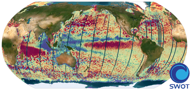
Altimetry product SWOT (KaRIn + nadir) Level 3 Ocean - version Unsmoothed
The SWOT L3_LR_SSH product provides ocean topography measurements obtained from the SWOT KaRIn and nadir altimeter instruments, merged into a single variable. The dataset includes measurements from KaRIn swaths on both sides of the image, while the measurements from the nadir altimeter are located in the central columns. In the areas between the nadir track and the two KaRIn swaths, as well as on the outer edges of each swath (restricted to cross-track distances ranging from 10 to 60 km), default values are expected.
SWOT L3_LR_SSH is a cross-calibrated product from multiple missions that contains only the ocean topography content necessary for thematic research (e.g., oceanography, geodesy) and related applications. This product is designed to be simple and ready-to-use, and can be combined with other altimetry missions. The SWOT L3_LR_SSH product is a research-orientated extension of the L2_LR_SSH product, distributed by the SWOT project (NASA/JPL and CNES). SWOT L3_LR_SSH is managed by the SWOT Science Team project DESMOS.
The ['Unsmoothed'] version of SWOT L3_LR_SSH (the "Basic" and "Expert" versions are the subject of separate metadata sheets) includes each algorithm, correction, or external model incorporated into the SWOT L3_LR_SSH product as a separate layer. This ['Unsmoothed'] version which includes the MSS, MDT and geostrophic currents (absolute and anomalies) in addition to the SSHA and MDT on the 250 m KaRIn native grid. Like the Expert subproduct, it also integrates a quality flag, corrections and external models as separate layers.
References
Dibarboure, G., Anadon, C., Briol, F., Cadier, E., Chevrier, R., Delepoulle, A., Faugère, Y., Laloue, A., Morrow, R., Picot, N., Prandi, P., Pujol, M.-I., Raynal, M., Tréboutte, A., and Ubelmann, C.: Blending 2D topography images from the Surface Water and Ocean Topography (SWOT) mission into the altimeter constellation with the Level-3 multi-mission Data Unification and Altimeter Combination System (DUACS), Ocean Sci., 21, 283–323, https://doi.org/10.5194/os-21-283-2025.
Simple
- Date (Creation)
- 2024-06-26
- Date (lastUpdate)
- 2024-07-05
- Date (lastUpdate)
- 2024-10-18
- Date (lastUpdate)
- 2025-03-15
- Version
- v2.0.1
- Status
- onGoing On going
- Cersat - Parameter
-
- Sea Surface Topography
- Cersat - Latency
-
- Less than 4 months
- Cersat - GCMD parameter
-
- /Sea Surface Topography/Sea Surface Height
- /Ocean Circulation/Ocean Currents
- /Tides/Tidal Height
- Centre de données ODATIS
-
- CDS-AVISO
- Specific usage
- Update
- Use limitation
- None
- Access constraints
- unrestricted
- Use constraints
- Other restrictions
- Other constraints
- Open Licence
- Other constraints
- "The SWOT_L3_LR_SSH product, derived from the L2 SWOT KaRIn low rate ocean data products (NASA/JPL and CNES), is produced and made freely available by AVISO and DUACS teams as part of the DESMOS Science Team project". AVISO/DUACS, 2024. SWOT Level-3 KaRIn Low Rate SSH Unsmoothed (v2.0.1) [Data set]. CNES. https://doi.org/10.24400/527896/A01-2024.003
- Unique resource identifier
- aa2927ad-d1d6-4867-89d3-1311bc11e6bb
- Association Type
- Cross reference
- Unique resource identifier
- 8c961685-cecb-41d9-b2d9-2a22cdd3d0c2
- Association Type
- Cross reference
- Spatial representation type
- grid Grid
- Distance
- 250 m
- Topic category
-
- Oceans
))
- Begin date
- 2023-03-30
- Reference system identifier
- http://www.opengis.net/def/crs/EPSG/0/4326
- Distribution format
-
-
NetCDF
(
4
)
-
NetCDF
(
4
)
OnLine resource
- OnLine resource
-
SWOT L3_LR_SSH Unsmoothed
(
WWW:LINK
)
THREDDS
- OnLine resource
-
Other document
(
WWW:LINK
)
Poster at SWOT Science Team 2023, Dibarboure et al. SWOT Level-3 Overview algorithms and examples
- OnLine resource
-
Other document
(
WWW:LINK
)
Presentation at SWOT Science Team 2023, Dibarboure et al. SWOT Level-3 Overview algorithms and examples
- OnLine resource
-
Software
(
WWW:LINK
)
SWOT Ocean data tutorials
- OnLine resource
-
Other document
(
WWW:LINK
)
AVISO SWOT Orbit files (kml and shapefile) for the 1-day and 21-day orbits
- OnLine resource
-
Web link (URL)
(
WWW:LINK
)
Produit altimétrique SWOT (KaRIn + nadir) Niveau 3 Océan - version Basic
- OnLine resource
-
User guide
(
WWW:LINK
)
Product User Manual (handbook)
- OnLine resource
-
Web link (URL)
(
WWW:LINK
)
Produit altimétrique SWOT (KaRIn + nadir) Niveau 3 Océan - version Expert
- OnLine resource
-
Product notices
(
WWW:LINK
)
SWOT L3_LR_SSH product: planned changes, rationale, expected improvements and known issues
- Distribution format
-
- OnLine resource
- Digital Object Identifier (DOI) ( DOI )
- Hierarchy level
- Dataset
- Description
- Production and distribution of the Unsmoothed SWOT L3_LR_SSH (250-m) version 1.0 product derived from the L2_LR_SSH version C for the Calibration (cycles 474 - 578) phase only.
- Date / Time
- v1.0 2024-06-14
- Hierarchy level
- Dataset
- Description
- Updated product with the release of version 1.0.1 (also derived from L2_LR_SSH version C) to correct an inverted land/sea mask anomaly for both the Calibration (cycles 474 - 578) phase and the Science (cycles 1 - 6 only) phases.
- Date / Time
- v1.0.1 2024-07-25
- Hierarchy level
- Dataset
- Description
- Updated product with the release of version 1.0.2 (also derived from L2_LR_SSH version C) for both the Calibration (cycles 474 - 578) phase and the Science (cycles 1 - 16 only) phases.
- Date / Time
- v1.0.2 2024-10-18
- Hierarchy level
- Dataset
- Description
- Updated product with the release of version 1.0.2 (also derived from L2_LR_SSH version C) for both the Calibration (cycles 474 - 578) phase and the Science (cycle 1 - ongoing) phases.
- Date / Time
- v2.0.1 2025-03-15
- Hierarchy level
- Dataset
- Attribute description
- pass
- Processing level code
- L3 /
Overviews

Spatial extent
))
Provided by

 Catalogue PIGMA