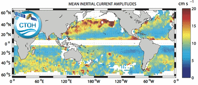
Climatology of near-inertial currents
Global climatology of near-inertial current characteristics from satellite-tracked drifters. Data analyzed: 8500 near-surface satellite-tracked drifter trajectories with drogues attached at 15 m depth. Gridded map with annual and seasonnal spans.
Simple
- Date (Publication)
- 2017-11-17
- Credit
- CTOH, LEGOS
- Centre de données ODATIS
-
- CDS-AVISO
- Type de jeux de donnée ODATIS
-
- /Données d'observation/satellite
- Theme
-
- courant, drifter
- Services Nationaux d'Observation
-
- SNO-CTOH
- ODATIS aggregation parameters and Essential Variable names
-
- Courants
- Use limitation
- Aucune condition ne s’applique
- Access constraints
- Other restrictions
- Use constraints
- Copyright
- Other constraints
- The only limitation is to reference the CTOH while using these data.
- Spatial representation type
- Grid
- Metadata language
- Français
- Character set
- UTF8
- Topic category
-
- Oceans
N
S
E
W
))
- Begin date
- 1999-07
- End date
- 2006-12 Before
- Geometric object type
- Point
- Distribution format
-
-
(
)
-
(
)
- OnLine resource
- accès aux produits CTOH ( WWW:LINK )
- Hierarchy level
- Dataset
- Statement
- Chaigneau, A., O. Pizarro, and W. Rojas (2008), Global climatology of near-inertial current characteristics from Lagrangian observations, Geophys. Res. Lett., 35, L13603, doi:10.1029/2008GL034060.
- File identifier
- f3c92e6d-a6b1-47eb-87e3-69fde36b31ad XML
- Metadata language
- Français
- Character set
- UTF8
- Hierarchy level
- Dataset
- Date stamp
- 2024-10-15T14:38:36.396743Z
- Metadata standard name
- ISO 19115:2003/19139 - SEXTANT
- Metadata standard version
- 1.0
Overviews

CTOH inertial currents
Spatial extent
N
S
E
W
))
Provided by

Associated resources
Not available
 Catalogue PIGMA