 Catalogue PIGMA
1998
Type of resources
Available actions
Topics
Keywords
Contact for the resource
Provided by
Years
Formats
Representation types
Update frequencies
status
Scale
Resolution
-
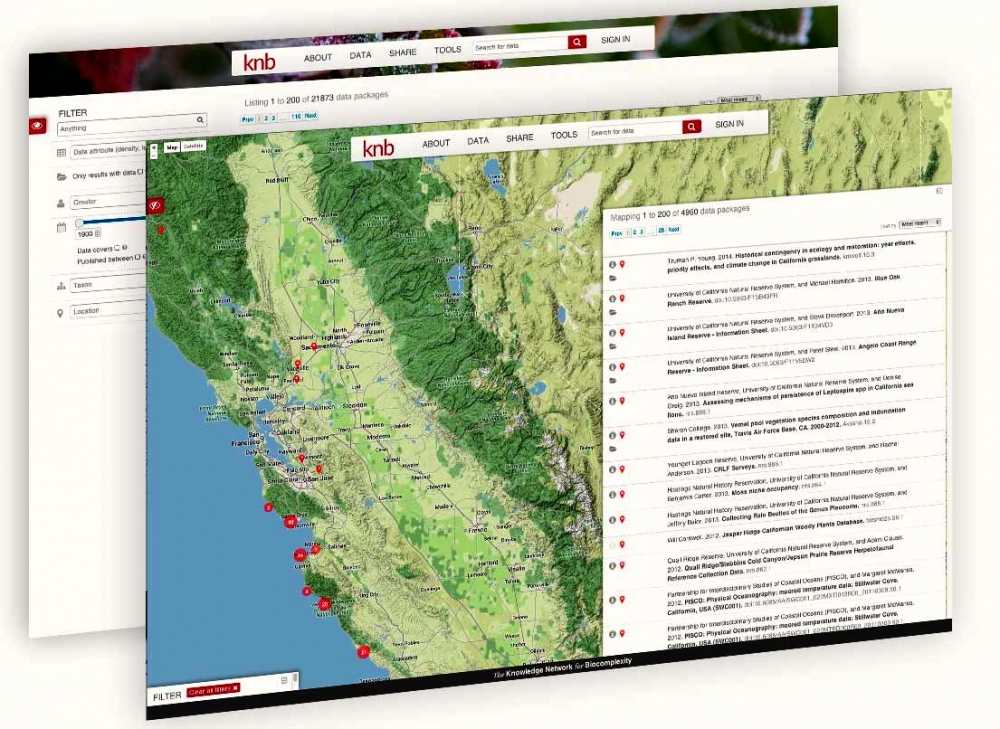
The Knowledge Network for Biocomplexity (KNB) is an international repository intended to facilitate ecological and environmental research. The KNB was launched in 1998 with a grant from the National Science Foundation (NSF), with the purpose of being the long term home for synthesis datasets and research products generated by National Center for Ecological Analysis and Synthesis (NCEAS) working groups. Since then, NCEAS has continued to operate the KNB not only as an archive for NCEAS working group products, but also for the broader ecology and environmental science community. The KNB acceps all environmental or ecological related data and publishes datasets with Digital Object Identifiers for the express purpose of ensuring long-term access to these datasets. We strive to abide by FAIR (findable, accessible, interoperable, resuble) principles of data sharing and preservation. For scientists, the KNB is an efficient way to share, discover, access and interpret complex ecological data. Due to rich contextual information provided with KNB data, scientists are able to integrate and analyze data with less effort. The data originate from a highly-distributed set of field stations, laboratories, research sites, and individual researchers. The foundation of the KNB is the rich, detailed metadata provided by researchers that collect data, which promotes both automated and manual integration of data into new projects.
-
Photographies aériennes IGN de 1998 au 1/8000 scannées et géoréférencées par l'ONF
-
Nombre de demandeurs d'emploi de catégorie A (à la recherche d'emploi et sans emploi ou en activité réduite) par communes en Aquitaine au 31/12/2010.
-
Union de la tache urbaine 1973 et 1996
-

Répartition géographique des secteurs de premier appel. Date de Publication : 2009
-

Ensemble des espaces aménagé pour le stockage du bois sur le département du Lot-et-Garonne. Le stockage du bois rentre dans le cadre de la gestion des forêts et intervient suite au débardage qui consiste à déplacer le bois depuis le lieu de coupe jusqu'à l'aire de dépôt. \\nCes aires de dépôts se matérialisent par un renforcement (empierrement sur une largeur et une longueur importantes) en début de piste.\\nDate de Publication : 2009
-
Cet ensemble de données représente les limites apparentes du domaine public non cadastré relatives à l'emprise des voies publiques telles que les rues, les places publiques, les routes nationales et départementales, les voies de la métropole et les chemins ruraux. Il contient 5 jeux de données permettant de décrire l'emprise de ce domaine public non cadastré ainsi que des éléments structurants visibles sur ces espaces publics tels que les bords de chaussées ou la vocation particulière de ces espaces (parking, jardins, etc.)
-

Ensemble des dispositifs de lutte contre l'incendie. Il s'agit d'un réseau souterrain d'eau sous pression permettant d'alimenter les fourgons d'incendie des sapeurs-pompiers. Ces réseaux sont dédiés à la défense extérieure contre l'incendie. Date de Publication : 2009
-

Ouvrages de franchissement empierrés ou en sol naturel, épousant le profil en travers de fossé ou de cours d'eau. Leur établissement nécessite de ne pas avoir un fossé trop profond ni trop étroit. Les passages à gué empierrés peuvent jouer un rôle de seuil fixant le profil en long et la progression de l'érosion. Ils conviennent aux cours d'eau de faible profondeur, d'ouverture assez large présentant de faibles pentes. Ces données concernent les territoires forestiers des communes du Lot-et-Garonne appartenant à une association syndicale autorisée de Défense des Forêts contre l'Incendie. Date de Publication : 2009
-
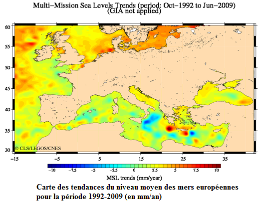
Système DUACS d’acquisition, de valorisation et d’information de l’altimétrie