 Catalogue PIGMA
2008
Type of resources
Available actions
Topics
Keywords
Contact for the resource
Provided by
Years
Formats
Representation types
Update frequencies
status
Scale
Resolution
-
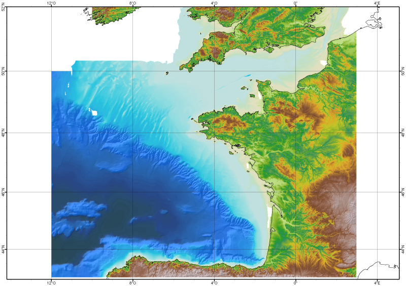
The Digital Terrain Model of the Bay of Biscaye and of the Channel is the result of the processing of a compilation of single and multibeam echosounder data, of DTMs and of chart countours produced before 2008 for hydrodynamic modeling..
-
Auteur(s): Lehembre Adrien , Projet de reconversion d'un bâtiment industriel situé en centre ville touristique en un centre culturel intégrant médiathèque, librairie ainsi que d'un lieu d'exposition à Bergerac (Dordogne)
-
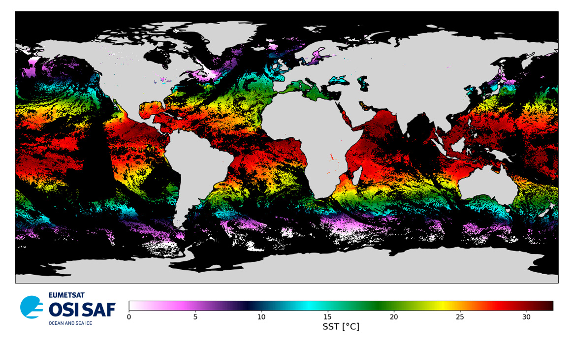
Level 3 twice-daily sub-skin Sea Surface Temperature derived from AVHRR on Metop-A, global and re-projected on a 0.05° regular grid, in GHRSST compliant netCDF format. The satellite input data has successively come from Metop-A and Metop-B level 1 data processed at EUMETSAT. SST is retrieved from AVHRR infrared channels (3.7, 10.8 and 12.0 µm) using a multi-spectral algorithm and a cloud mask. Atmospheric profiles of water vapor and temperature from a numerical weather prediction model, Sea Surface Temperature from an analysis, together with a radiative transfer model, are used to correct the multispectral algorithm for regional and seasonal biases due to changing atmospheric conditions.The quality of the products is monitored regularly by daily comparison of the satellite estimates against buoy measurements. The product format is compliant with the GHRSST Data Specification (GDS) version 2. Users are advised to use data only with quality levels 3, 4 and 5.
-
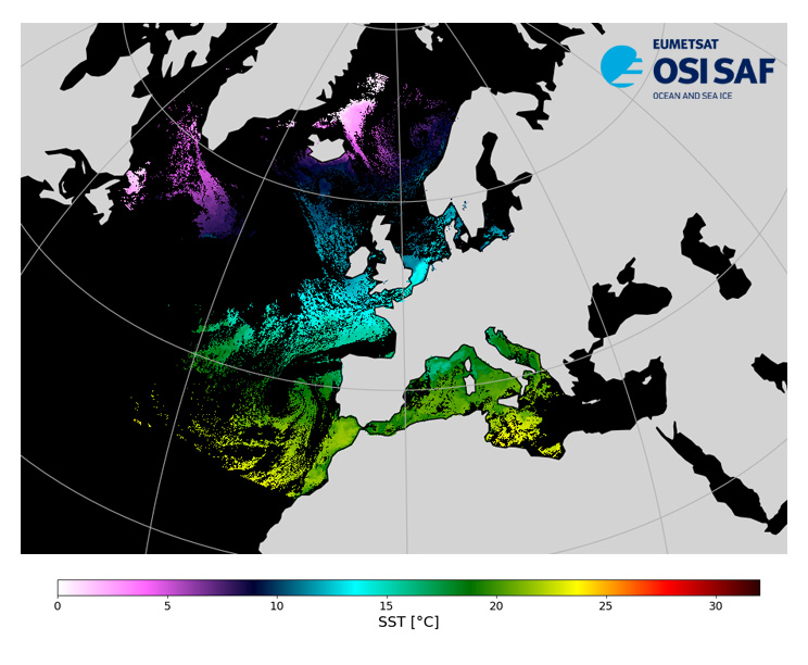
Level 3, four times a day, sub-skin Sea Surface Temperature derived from AVHRR on Metop satellites and VIIRS or AVHRR on NOAA and NPP satellites, over North Atlantic and European Seas and re-projected on a polar stereographic at 2 km resolution, in GHRSST compliant netCDF format. This catalogue entry presents Metop-A North Atlantic Regional Sea Surface Temperature. SST is retrieved from infrared channels using a multispectral algorithm and a cloud mask. Atmospheric profiles of water vapor and temperature from a numerical weather prediction model, Sea Surface Temperature from an analysis, together with a radiative transfer model, are used to correct the multispectral algorithm for regional and seasonal biases due to changing atmospheric conditions. The quality of the products is monitored regularly by daily comparison of the satellite estimates against buoy measurements. The product format is compliant with the GHRSST Data Specification (GDS) version 2.Users are advised to use data only with quality levels 3,4 and 5.
-
Les bases sur les flux de "déplacements domicile-études" fournissent, pour l'ensemble des communes d'Aquitaine, les effectifs correspondant aux croisements du lieu de résidence avec le lieu d'études en 2006. Les données sont issues de l'exploitation complémentaire du recensement afin d'assurer leur cohérence avec les fichiers détail bilocalisés qui seront eux-mêmes issus de l'exploitation complémentaire (cf. rubrique Source). Elles sont présentées dans les limites géographiques en vigueur au 1er janvier 2008. Le fichier au format Excel, d'utilisation immédiate, concerne les principaux flux (flux >= 100), en raison de la limitation du nombre de lignes avec Excel 2000 et les versions antérieures. Le fichier BTX_FM_DET_2006.xls comporte deux onglets : 1 - un onglet " TOTAL " où chaque ligne correspond à une commune de résidence avec en colonnes : - son code géographique, - le libellé correspondant, - la population stable (Population de 2 ans ou plus scolarisée dans la commune de résidence), - la population mobile (Population de 2 ans ou plus scolarisée hors de la commune de résidence), - la population totale (en référence au champ statistique retenu, c'est-à-dire Population de 2 ans ou plus scolarisée). 2 - un onglet " FLUX >= 100 " où chaque ligne fournit le flux d'élèves ou d'étudiants se déplaçant entre une commune de résidence et une commune d'études, avec un seuil fixé à 100. Chaque commune est représentée par son code géographique et le libellé correspondant. La consultation de ce tableau permet d'avoir rapidement une idée sur l'importance des flux de déplacements domicile-études entre deux communes. Pour analyser les flux entre deux zones constituées de regroupement de communes, il est recommandé d'utiliser le fichier de données au format Texte car il prend en compte tous les flux, sans considération de seuil. Pourquoi le seuil est fixé à 100 ? Un tableau au format Excel (Excel 2000 et versions antérieures) ne doit pas comporter plus de 65 000 lignes. Afin de respecter cette contrainte technique, seuls les flux importants (au minimum 100) figurent dans le deuxième onglet.
-
Les bases sur les flux de "déplacements domicile-travail " fournissent, pour l'ensemble des communes d'Aquitaine, les effectifs correspondant aux croisements du lieu de résidence avec le lieu de travail en 2006. Les données sont issues de l'exploitation complémentaire afin d'assurer leur cohérence avec les fichiers détail bilocalisés qui seront eux-mêmes issus de l'exploitation complémentaire du recensement. Elles sont présentées dans les limites géographiques en vigueur au 1er janvier 2008. Le fichier au format Excel, d'utilisation immédiate, concerne les principaux flux (flux >= 100), en raison de la limitation du nombre de lignes avec Excel 2000 et les versions antérieures. Le fichier BTX_FM_DTR_2006.xls comporte deux onglets : 1 - un onglet " TOTAL " où chaque ligne correspond à une commune de résidence avec en colonnes : - son code géographique, - le libellé correspondant, - la population stable (Actifs âgés de 15 ans ou plus travaillant dans leur commune de résidence), - la population mobile (Actifs âgés de 15 ans ou plus travaillant hors de leur commune de résidence), - la population totale (en référence au champ statistique retenu, c'est-à-dire Actifs occupés âgés de 15 ans ou plus) ; 2 - un onglet " FLUX >= 100 " où chaque ligne fournit le flux de personnes se déplaçant entre une commune de résidence et une commune du lieu de travail, avec un seuil fixé à 100. Chaque commune est représentée par son code géographique et le libellé correspondant. La consultation de ce tableau permet d'avoir rapidement une idée sur l'importance des flux de déplacements domicile-travail entre deux communes. Pour analyser les flux entre deux zones constituées de regroupement de communes, il est recommandé d'utiliser le fichier de données au format Texte car il prend en compte tous les flux, sans considération de seuil. Pourquoi le seuil est fixé à 100 ? Un tableau au format Excel (Excel 2000 et versions antérieures) ne doit pas comporter plus de 65 000 lignes. Afin de respecter cette contrainte technique, seuls les flux importants (au minimum 100) figurent dans le deuxième onglet.
-
Carte Communale (CC) numérisée. Ce lot informe du droit à bâtir sur la commune de CHAMPS-ROMAIN. Cette CC est numérisée conformément aux prescriptions nationales du CNIG.
-
Planisphère
-
Évaluation de la qualité de l'air sur la commune de Bordeaux, réalisée par laboratoire mobile. Année 2007
-
Cette donnée trace les restes de la voirie de l'Etat Major