 Catalogue PIGMA
/Milieu biologique/Espèces/Espèces d'intérêt halieutique
Type of resources
Available actions
Topics
Keywords
Contact for the resource
Provided by
Years
Formats
Representation types
Update frequencies
status
Scale
Resolution
-

Évaluation de l’atteinte du bon état écologique au titre du descripteur 3 « Espèces exploitées à des fins commerciales ». Exemple de l’agrégation des rectangles statistiques CIEM pertinents pour l’évaluation du stock de morue de l’Atlantique (Gadus morhua) de mer du Nord et Manche Est (zones CIEM IIIa, IV, VIId) Exemple de l’agrégation des secteurs statistiques CGPM pertinents pour l’évaluation du stock de merlu (Merluccius merluccius) du golfe du Lion (zone GSA07) Exemple de l’agrégation des rectangles statistiques CIEM pertinents pour l’évaluation du stock de Bar (Dicentrarchus labrax) de mer du Nord/Manche/Mer Celtique Exemple de l’agrégation des rectangles statistiques CIEM pertinents pour l’évaluation du stock de cardine franche (Lepidorhombus whiffiagonis) de Mer Celtique et Golfe de Gascogne Ces cartes ont été produites pour les Synthèses par SRM. La totalité des cartes produites pour ce descripteur sont visualisables dans le Rapport et les Fiches détaillées (Liens - Accès aux données).
-

Cette carte présente les valeurs du coefficient de diffusion acoustique par mille nautique (NASC ; nautical area scattering coefficient) attribué à l’anchois (Engraulis encrasicolus) en 2019, 2020, 2021 et 2022, mettant en évidence le gradient régional d’abondance de cette espèce. La carte a été élaborée à partir d'une interpolation pondérée par l'inverse de la distance appliquée aux résultats des campagnes MEDIAS (MEDiteranean International Acoustic Survey ) réalisées en Méditerranée. Des informations détaillées sur la méthodologie d'acquisition et de traitement des données acoustiques sont disponibles dans le guide des campagnes MEDIAS . De plus, des détails sur la méthode d'interpolation utilisée sont fournis dans le rapport de la 16ème réunion du groupe de travail.
-
Les données de débarquements géolocalisés de capture de pêche de la zone GSA 07, de 2015 à 2019, ont été obtenues auprès du Système d’Information Halieutique (SIH) d’Ifremer avec l’autorisation de la Direction des pêches maritimes et de l’aquaculture (DPMA) du Ministère de l’Agriculture et de la Pêche. L’effort de pêche de 6 engins ayant un impact sur le fond susceptibles de générer une mortalité des petites espèces benthiques non commerciales a été calculé annuellement entre 2015-2019 puis l'effort moyen et l'écart-type ont été calculés sur cette période.
-

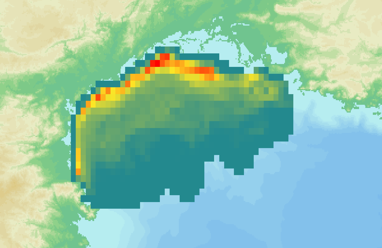
La densité (nombre individus/km²) a été calculée annuellement à partir des données de la campagne MEDITS entre 1994 et 2019 puis a été moyennée par station sur cette période. Les données ont été transformées par logarithme décimal log10 (x+1) puis une analyse variographique et un krigeage ordinaire ont été effectués pour interpoler les données dans le Golfe du Lion. Une carte de variance de krigeage a été calculée pour chaque espèce et chaque pas de temps.
-

La densité (nombre individus/km²) a été calculée annuellement à partir des données de la campagne MEDITS entre 1994 et 2019 puis la moyenne et l'écart-type ont été calculés par station sur cette période. Les densités ont été calculées par stade de vie quand cela était possible (juvénile, adulte, indéterminé).
-

Les données de débarquements géolocalisés de capture de pêche de la zone GSA 07, de 2015 à 2019, ont été obtenues auprès du Système d’Information Halieutique (SIH) d’Ifremer avec l’autorisation de la Direction des pêches maritimes et de l’aquaculture (DPMA) du Ministère de l’Agriculture et de la Pêche. La capture par unité d'effort (CPUE) correspond la quantité débarquée de l’espèce en kilogrammes divisée par le temps passé à pêcher l’espèce en heure. La CPUE (kg/tps) a été calculée annuellement entre 2015-2019 puis la moyenne et l'écart-type ont été calculés sur cette période par espèce.
-
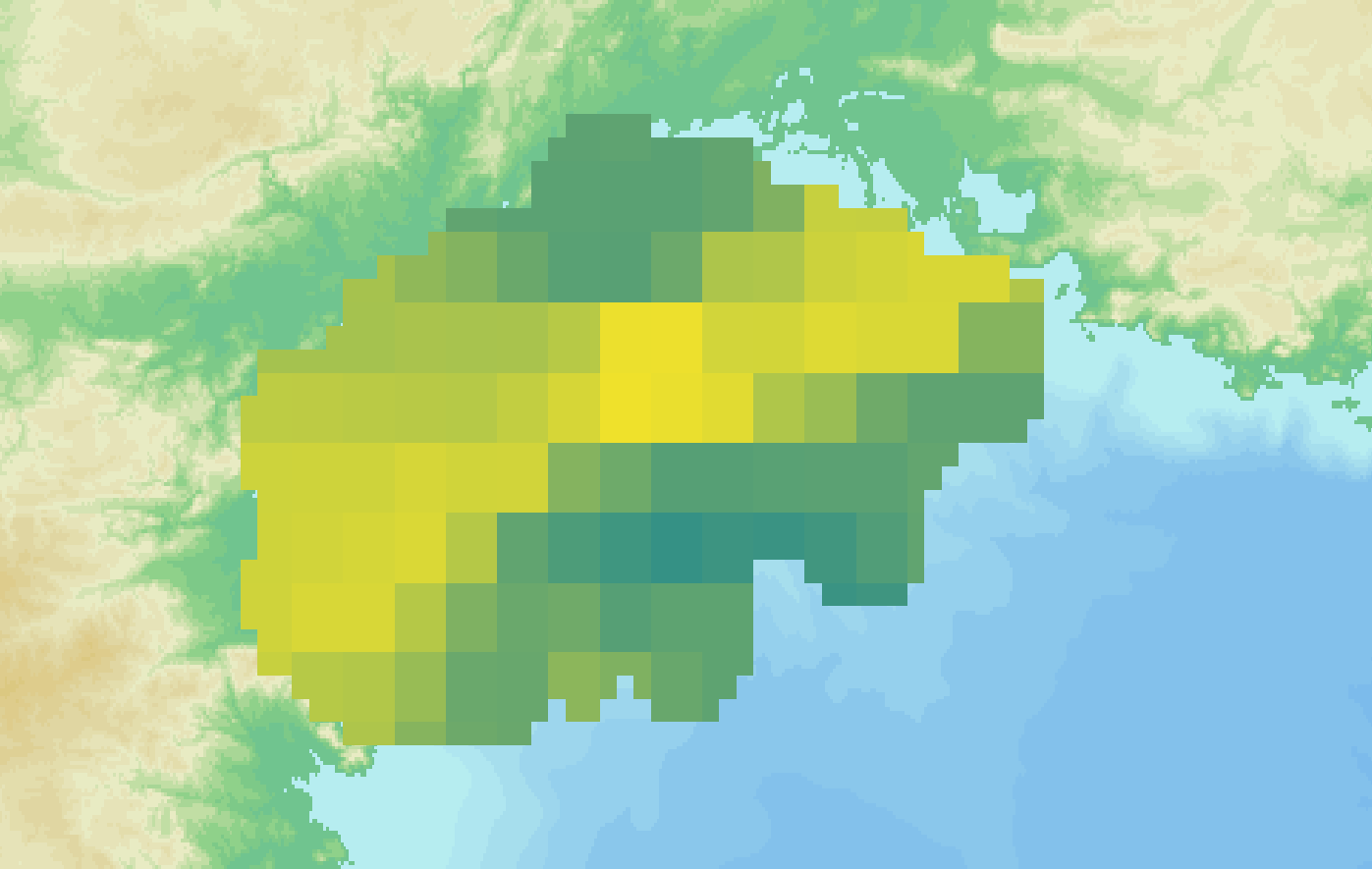
La densité (nombre individus/km²) a été calculée annuellement à partir des données de la campagne MEDITS entre 1994 et 2019. Les données ont été transformées par logarithme décimal log10 (x+1) puis une analyse variographique et un krigeage ordinaire ont été effectués pour interpoler les données de densité dans le Golfe du Lion. Une carte de variance de krigeage a été calculée pour chaque espèce et chaque pas de temps.
-

La densité (nombre individus/km²) moyenne et son écart-type ont été calculés sur la période 2015-2019 à partir des cartes annuelles.