Fluorescence
Type of resources
Available actions
Topics
Keywords
Contact for the resource
Provided by
Years
Formats
Representation types
Scale
-

This In Situ delayed mode product integrates the best available version of in situ oxygen, chlorophyll / fluorescence and nutrients data. The latest version of Copernicus delayed-mode BGC (bio-geo-chemical) product is also distributed from Copernicus Marine catalogue.
-

This dataset contains bin-averaged optical particle measurements from Biogeochemical Argo floats. Full description of data and methodology is contained in the manuscript submitted to Science entitled "Particle fragmentation exerts strong control on biological sequestration of CO2 by the oceans". Optical measurements are particulate backscattering and chlorophyll fluorescence, and each have been partitioned into large (>100 µm) and small (<100 µm) size classes for use in estimating the rate of fragmentation of large, sinking partiles. The data cover 34 high-latitude open-ocean mesopelagic sinking particle plumes in the supolar North Atlantic and the Southern Ocean observed at 1 m vertical resolution and 2-5 day temporal resolution by profiling floats over a 30-day period. Each 30-day period is divided into five temporal bins of six days each. Vertical binning is at 50-meter intervals from the 250-950 m.
-

There are at least a dozen small hyper-turbid estuaries facing the Bay of Biscay, geographically situated between the two major estuaries of the Gironde and the Loire. MAGEST and SYVEL high-frequency multi-site monitoring revealed that the Loire, and to a lesser extent the Gironde, are subject to summer hypoxia. These observations raised the question of the potential occurrence of hypoxia in the small estuaries in between, motivating an investigation of dissolved oxygen in one of them, the Charente estuary. Oxygen and salinity sensors were placed at L'Houmée (2019), Tonnay-Charente (2018; 2019), Rochefort (2020; 2021; 2022), Martrou (2020) during summer, the most critical period for dissolved oxygen; a multiparameter probe was placed at Tonnay-Charente from April to November 2020. Longitudinal investigations along the estuary axis were also carried out during the summers of 2018 and 2019. All the measurements were acquired at 0.5 ± 0.2 meters below the surface. The dataset enabled us to identify the occurrence of summer hypoxia and an oxygen depletion zone in the Charente estuary. These results resulted in the implementation of high-frequency monitoring at Tonnay-Charente, operational since November 2020.
-

Based on the consolidation of the Ifremer networks RESCO (https://doi.org/10.17882/53007) and VELYGER (https://doi.org/10.17882/41888), the general objective of the ECOSCOPA project is to analyze the causes of spatio-temporal variability of the main life traits (Larval stage - Recruitment - Reproduction - Growth – Survival – Cytogenetic anomalies) of the Pacific oyster in France and follow their evolution over the long term in the context of climate change. The high frequency environmental data are monitored since 2010 at several stations next to oyster farm areas in eight bays of the French coast (from south to north): Thau Lagoon and bays of Arcachon, Marennes Oléron, Bourgneuf, Vilaine, Brest, Mont Saint-Michel and Veys (see map below). Sea temperature and practical salinity are recorded at 15-mins frequency. For several sites, fluorescence and turbidity data are also available. Data are acquired with automatic probes directly put in oyster bags or fixed on metallic structure at 50 cm over the sediment bottom, except for Thau Lagoon whose probes are deployed at 2m below sea surface. Since 2010, several types of probes were used: STP2, STPS, SMATCH or WiSens CTD from NKE (www.nke-instrumentation.fr) and recently ECO FLNTU (www.seabird.com). The probes are regularly qualified by calibrations in the Ifremer coastal laboratories. Precision estimated of the complete data collection process is: temperature (±0.1°C), salinity (±0.5psu), in vivo fluorescence (±10%), turbidity (±10%). The data are qualified into several levels: 0-No Quality Check performed, 1-Good data, 2-Probably good data, 3-Probably bad data, 4-Bad data, 5-Value changed, 7-Nominal value, 8-Interpolated value, 9-Missing value.
-

The COAST-HF/Arcachon-Ferret time series characterizes the hydrology of the interface between the Arcachon lagoon, located in the South-Western France, and the Atlantic Ocean. A buoy belonging to Phares et Balises is instrumented with a multi-parametric probe that records sub-surface temperature, conductivity, depth, turbidity and fluorescence every 10 minutes since February 2018. It is opérated by the OASU and EPOC teams (Univ. Bordeaux/CNRS). COAST-HF (Coastal OceAn observing SysTem - High Frequency; www.coast-hf.fr) is a national observation network accredited by the CNRS as a national Earth Science Observatory (Service National d’Observation: SNO). It aims to federate and coordinate a set of 14 fixed platforms instrumented with high-frequency in situ measurements for key parameters of coastal waters. The COAST-HF/Arcachon-Ferret buoy is one of them. COAST-HF is part of the French Research Infrastructure dedicated to coastal ocean observations (RI ILICO, https://www.ir-ilico.fr). Data are transmitted to the Coriolis Côtier database (https://data.coriolis-cotier.org/). Data are raw data.
-

SOMLIT (Service d'Observation en Milieur Littoral) : a French Coastal Monitoring Network Coastal zones are where land, ocean and atmosphere interact. They are important for the exchange of matter and energy, and play a key role in (biogeo)chemical cycles at global scale. These environments are characterised by significant spatial and temporal variability of their physico-chemical and biological parameters due to local and seasonal meteorological drivers which are exacerbated by large-scale climate drivers (e.g. global warming, modification of the wind regime) and local-scale anthropogenic drivers (e.g. nutrient cycle changes linked to the use of fertilisers or the construction of large installations such as dams). These driving mechanisms are often interconnected. In the context of global warming (due to climate and human-induced changes), the identification and understanding of their impact on coastal marine and littoral ecosystems is essential. The scientific objective of SOMLIT is to 1) characterise the multi-decadal evolution of coastal marine and littoral ecosystems, and 2) determine the climatic and anthropogenic drivers. In order to meet this objective, a nationally coordinated multi-site monitoring system was set up in the mid-1990s. The observation strategy is the same for each of the 12 monitored ecosystems with fortnightly sampling and/or measurements, at high tide (for sites subject to tides): 1) in surface-water for a range of 15 parameters (temperature, salinity, dissolved oxygen, pH, nitrate, nitrite, ammonium, phosphate, silicate, suspended particulate matter, chlorophyll a, particulate organic carbon and nitrogen and stable isotopes of particulate organic carbon and nitrogen), 2) in surface-water for a range of 26 parameters of numbering and optical characteristics of pico- and nanoplankton), and 3) along the water column for temperature, salinity, fluorescence and PAR (vertical profiles of multi-parameter probes). SOMLIT’s activities are carried out under a quality assurance / quality control process based on the ISO 17025 standard. SOMLIT’s service provision objectives are to provide data and logistical support for research and other observation activities. SOMLIT has been officially accredited since 1996 as one of the CNRS (French National Centre for Scientific Research) National Observation Services (SNO). SOMLIT’s coordination is hosted by the Observatoire Aquitain des Sciences de l'Univers (University of Bordeaux / CNRS) and the service relies on strong partnerships with nine other institutions (University of Lille, University of the Littoral Opal Coast, University of Caen Normandy, Sorbonne University, University of Western Brittany, La Rochelle University, University of Montpellier, Aix Marseille University, National Museum of Natural History). SOMLIT is one of the nine networks that compose France’s Coastal Research Infrastructure (ILICO). SOMLIT has strong ties with ILICO’s other networks such as the SNOs MOOSE (Mediterranean Ocean Observing System on Environment), PHYTOBS (microphytoplankton monitoring) and COAST-HF (Coastal Ocean Observing System - High Frequency).
-

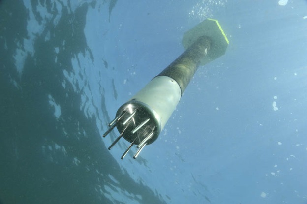
ARVOR-C is a subsurface profiling float designed to operate in coastal environments and to perform oceanographic measurements like a moored installation. Its design has been improved to reduce its drift thanks to a seabed claw and anti-drift claws, an optimized profile speed (~ 25 cm / s) and a short-period data transmission. It is able to process more than 300 profiles and real-time data transmission via Iridium satellite system.
-

COAST-HF est un Service National d'Observation qui vise à fédérer et cordonner à l'échelle du littoral français un ensemble de plateformes fixes instrumentées de mesures in situ hautes fréquences pour des paramètres clés des eaux côtières. Ce réseau s'inscrit dans l'Infrastructure de Recherche ILICO. Il est constitué de 14 bouées ancrées instrumentées et autonomes permettant la mesure en continu de paramètres physiques et bio-géochimiques.
 Catalogue PIGMA