 Catalogue PIGMA
Habitats and biotopes
Type of resources
Available actions
Topics
Keywords
Contact for the resource
Provided by
Years
Formats
Representation types
Update frequencies
status
Scale
Resolution
-

Raw reads for the assembly of Gambusia holbrooki genome.
-

This dataset consists of metatranscriptomic sequencing reads corresponding to coastal micro-eukaryote communities sampled in Western Europe in 2018 and 2019.
-

This study gathers multi-year environmental sequencing datasets generated within the French ROME pilot observatory network. It includes eDNA metabarcoding and RNA-based analyses from water samples, oyster tissues, and viral fractions collected across four French estuarine ecosystems between 2020 and 2023, supporting integrated monitoring of coastal microbiomes and microbial hazards.
-

Sequenced samples are city center wastewater sampled by passive samplers. Variants are identified by Illumina Miseq sequencing.
-

The eleven collected wild strains of T. lutea were compared phenotypically, in particular with regard to their pigment and lipid profiles. The genome of each T. lutea strain was also sequenced to investigate the genetic structure and genome organisation of this species. Collected data were summarized in a genome browser to provide easy-to-use support for the scientific community (https://genomes-catalog.ifremer.fr). This provides an important resource- to understand, exploit and predict the biodiversity of this species.
-

Comparison between 3 kits, Roche, Twist Biosciences and Illumina on the ability to enrich environmental samples to viral sequences. 5 sewage samples were extracted in triplicats with selective extraction protocol.
-
This study aims to compare different metabarcoding sequences of commercially fished shrimps collected by tree counties on the North Brazil Shelf Large Marine Ecosystem
-

Genetic diversity is often considered a key factor in a species’ ability to adapt to environmental changes and our aim was to understand the biological, ecological, and biogeographic factors that explain differences in genetic diversity among marine fish. Therefore, whole genomes of 160 individual marine fish were sequenced to a minimum depth of 15×, enabling near-complete representation of each diploid genome.
-
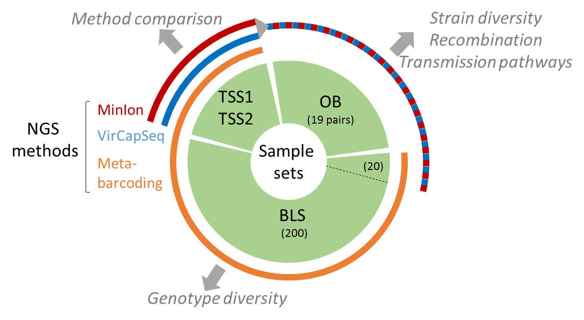
The present data set concerne metabarcoding raw reads produced using 4 different PCR targeting polymerase or capside coding region of the genoyupe I and II of norovirus. Test samples of norovirus with serial dilutions in pure water and after a bio-accumulation in oysters. Sequencing was made after VirCapSeq-VERT approach.
-

WGS of SARS-CoV-2 by Oxford Nanopore Technology from raw wastewater samples collected in France, 2020-2021