 Catalogue PIGMA
SNO-CTOH
Type of resources
Available actions
Topics
Keywords
Provided by
Years
Formats
Representation types
Resolution
-

Along-track altimetric GDR (Geophysical Data Record) products , geophysical and environmental corrections to apply. Available missions are: GFO, Topex/Poseidon, Envisat, Cryosat-2, Jason-1, Jason-2, Jason-3, Saral/AltiKa. Missions with several successive orbital types are treated in their entirety. Compared to the original version of the GDR files distributed by the CNES, ESA, NASA and ISRO agencies, the CTOH proposes new corrections and parameters in these files, which are to be applied to the initial altimetry measurement, according to user needs. Children metadata files are available for each mission.
-
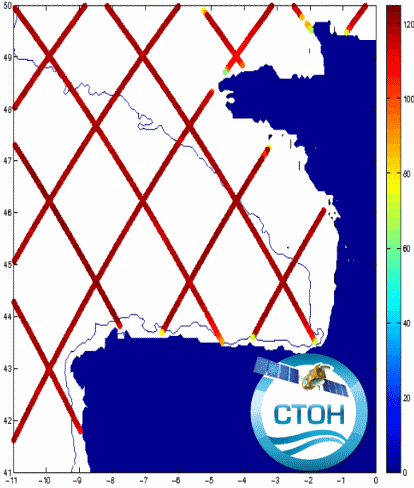
The CTOH computes and distributes specific, coastal along-track sea level anomalies (SLA) using its X-TRACK processor over 23 regions, for all precise altimeter missions : Topex/Jason-1/Jason-2/Jason-3 (+Topex Interleaved orbit (TPN)/Jason-1 Interleaved orbit (J1N)), SARAL/AltiKa, Envisat, Geosat Follow On The CTOH computes and distributes specific, coastal along-track sea level anomalies (SLA) using its X-TRACK processor for all precise altimeter missions : Topex/Poseidon (TP), Jason-1 (J1) , Jason-1 interleaved (J1N), Topex/Poseidon interleaved (TPN), Jason-2, Geosat Follow on (GFO) and Envisat. X-TRACK cover today all the coastal oceans, with 23 new regions.
-
Multimission altimetry-derived gridded from Ssalto/Duacs products backward-in-time Finite Size Lyapunov Exponents and Orientations of associated eigenvectors
-
-
GDR L2 from US Navy augmented by CTOH with new corrections or parameters
-
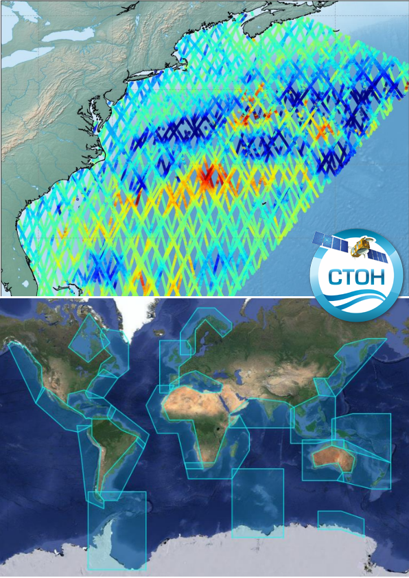
The CTOH computes and distributes specific, coastal along-track sea level anomalies (SLA) using its X-TRACK processor over 23 regions, for all precise altimeter missions : Topex/Jason-1/Jason-2/Jason-3 (+ Interleaved orbits for Topex, Jason-1, Jason-2), ERS-1, ERS2, Envisat, SARAL/AltiKa, Geosat Follow On, HaiYang-2A and Sentinel-3A. The Sea Level Anomaly time series have been computed with the X-TRACK processing system (developed at CTOH/LEGOS) but, unlike the previous version of the X-TRACK dataset, this X-TRACK L2P dataset is computed from the Level 2 Plus (L2P) products distributed by CDS-SAT-AVISO. The X-TRACK L2P product is also more complete since in addition to the sea surface height anomalies, it contains the significant wave height and the backscatter coefficient. The applied altimetry corrections are also provided in this product.
-
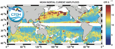
Global climatology of near-inertial current characteristics from satellite-tracked drifters. Data analyzed: 8500 near-surface satellite-tracked drifter trajectories with drogues attached at 15 m depth. Gridded map with annual and seasonnal spans.
-
Jason-2 GDR L2 version D from CNES/NASA augmented by CTOH with new corrections or parameters. Both successive orbits are proposed: reference orbit: 2008/07/04-2016/10/02 orbit interleaved: 2016/10/13-2017/03/15
-

Jason-1 GDR L2 version C from CNES/NASA augmented by CTOH with new corrections or parameters. Les 3 orbites de Jason-1 sont proposées: orbite de référence : 2002/01/15-2009/01/26 orbite interleaved: 2009/02/10-2012/03/03 orbite géodésique: 2012/05/07-2013/06/21
-
Nouvelle structure de données altimétriques dérivée du format L2 GDR fourni par les agences spatiales. Une trace normalisée est une structure de données dans laquelle les mesures altimétriques (GDR) collectées au cours de cycles successifs sont organisés dans des cellules le long de l'orbite. Cette organisation facilite l'analyse colinéaire des données altimétriques, permettant ainsi d'effectuer des analyses telles que des séries temporelles, des calculs de moyennes, ainsi que d'autres types d'analyses des données dans ces cellules. Cette structure peut être fournie par le CTOH pour toute mission altimétrique sur orbite répétitive (ERS-2, Envisat, SARAL, Jason-1, Jason-2, Jason-3, Sentinel-3A et B).