hydrodynamique
Type of resources
Available actions
Topics
Keywords
Contact for the resource
Provided by
Years
Formats
Representation types
Update frequencies
status
Scale
Resolution
-
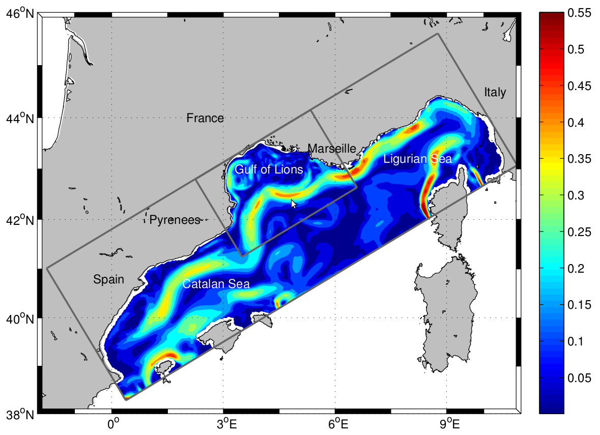
The LAgrangian Transport EXperiment (LATEX) project (2008-2011) is designed to study the mechanisms of formation of anticyclonic eddies and their influence on cross-shelf exchanges in the western part of the GoL. The dynamics of mesoscale eddies is particularly important in this part of the GoL since it represents a key region for regulating the outflow from the continental shelf. The eddy dynamics is investigated using Symphonie, a 3-dimensional, primitive equation model, with a free sea surface, hybrid sigma coordinates, based on Boussinesq and hydrostatic approximations [Marsaleix et al., 2006, 2008]. We use the upwind-type advection-diffusion scheme adapted by Hu et al. [2009] to improve the ability of the model to reproduce coastal mesoscale eddies in the western part of the GoL. In the present study, the model is implemented over the whole GoL with an horizontal resolution of 1 km × 1 km (Figure 1). The vertical discretization consists of 40-hybrid vertical levels. The vertical resolution varies from 1 m in the upper ocean to 40 m near the bottom. "For a complete review of the LATEX projet, see : - Petrenko, A., A., Doglioli, A.M., Nencioli, F., Kersalé, M., Hu, Z., d'Ovidio, F. (2017). A review of the LATEX project: mesoscale to submesoscale processes in a coastal environment. Ocean Dynam., 67:513 - doi: 10.1007/s10236-017-1040-9 - https://doi.org/10.1007/s10236-017-1040-9 ----- Le projet LAgrangian Transport EXperiment (LATEX) (2008-2011) est conçu pour étudier les mécanismes de formation des tourbillons anticycloniques et leur influence sur les échanges entre plateaux dans la partie occidentale du GdL. La dynamique des tourbillons à méso-échelle est particulièrement importante dans cette partie du GdL, car elle représente une région clé pour la régulation du flux sortant du plateau continental. La dynamique des tourbillons est étudiée à l'aide de Symphonie, un modèle d'équation primitive tridimensionnel, avec une surface de mer libre, des coordonnées sigma hybrides, basé sur Boussinesq et des approximations hydrostatiques [Marsaleix et al., 2006, 2008]. Nous utilisons le schéma d'advection-diffusion de type vent debout adapté par Hu et al [2009] pour améliorer la capacité du modèle à reproduire les tourbillons côtiers à méso-échelle dans la partie occidentale du GdL. Dans la présente étude, le modèle est mis en œuvre sur l'ensemble du GdL avec une résolution horizontale de 1 km × 1 km (Figure 1). La discrétisation verticale est constituée de 40 niveaux verticaux hybrides. La résolution verticale varie de 1 m dans la partie supérieure de l'océan à 40 m près du fond. Pour plus d'information sur le projet LATEX : - Petrenko, A., A., Doglioli, A.M., Nencioli, F., Kersalé, M., Hu, Z., d'Ovidio, F. (2017). A review of the LATEX project: mesoscale to submesoscale processes in a coastal environment. Ocean Dynam., 67:513 - doi:10.1007/s10236-017-1040-9 - https://doi.org/10.1007/s10236-017-1040-9
-
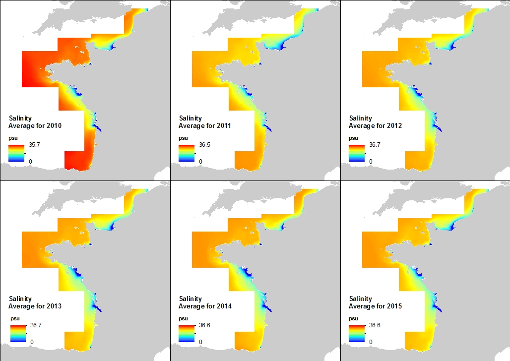
This annual statistics at 500m horizontal resolution was produced from the archived time series of MARS 3D physics model hindcast runs along French Atlantic Coast. The variable that is available here is the Salinity. Values are expressed in psu. The vertical level is the sea surface.
-
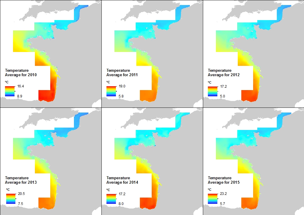
This annual statistics at 500m horizontal resolution was produced from the archived time series of MARS 3D physics model hindcast runs along French Atlantic Coast. The variable that is available here is Temperature. Values are expressed in Celsius degrees. In each pixel the value is an average of the values of the 40 vertical levels that are considered in the model.
-
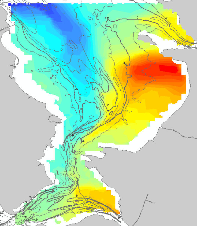
Résultat de la modélisation du temps de renouvellement ou Flushing time dans la baie de Marennes-Oléron représentant en jours le temps qu'il faut pour que 60% d'une maille soit renouvelée selon une condition de vent caractéristique : Ouest à 5m/s.
-
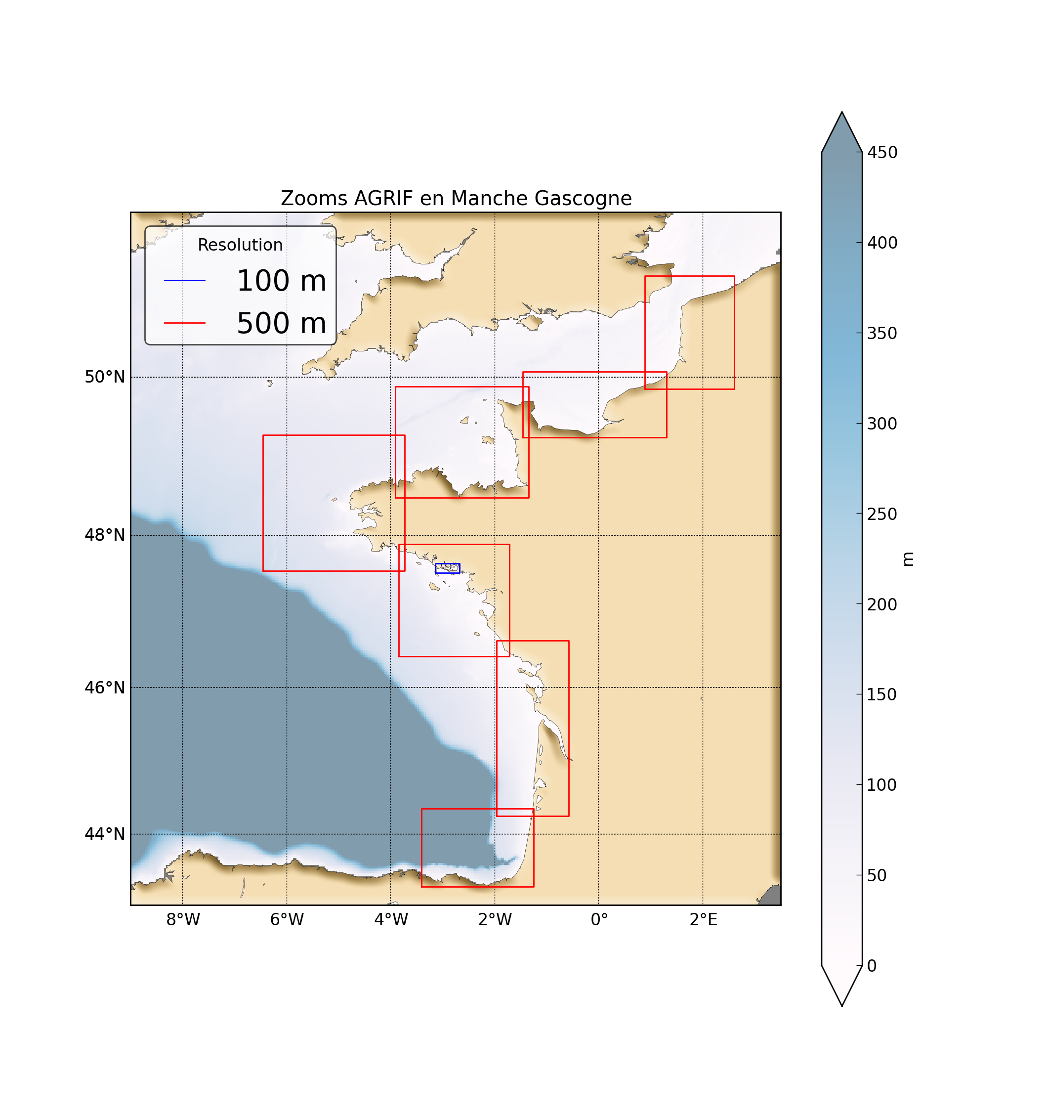
"Abstract: " Hydrodynamic database build with the MARS3D model along the french manche and atlantic coast at high spatial (500m) and temporal (1h) resolution "Details:" Seabed habitats maps are build from statistics models which need some data that describe the physical environment of the different species. Theses environmental factors are the salinity, temperature and shear stress (from waves and current) on the sea floor. Statistics are based on realistic and inter-annual simulations from 3D ocean models.Models output are currently available at a uniform resolution of 2.5 km along the whole French coast,as a part of the PREVIMER project (http://www.previmer.org) To increase the horizontal resolution of the model to 500m grid spacing, an on-line grid refinement technique has been carried out with the AGRIF library. (http://www-ljk.imag.fr/MOISE/AGRIF/) Seven zooms (with 500m resolution) have been implemented in the 2.5 km MANGAE configuration. From this configuration, an hindcast of six years (from 2010 to 2015) has been simulated and cover the french coast from spain to pas-de-calais area : "Main features of the hindcast" Horizontal resolution : 500m Vertical resolution : 40 sigma levels Temporal resolution : 1 Hour "Available physical parameters" ◦ 2D : Sea surface height and barotropic velocities (U and V components) ◦ 3D : Temperature, Salinity and baroclinic velocities
-
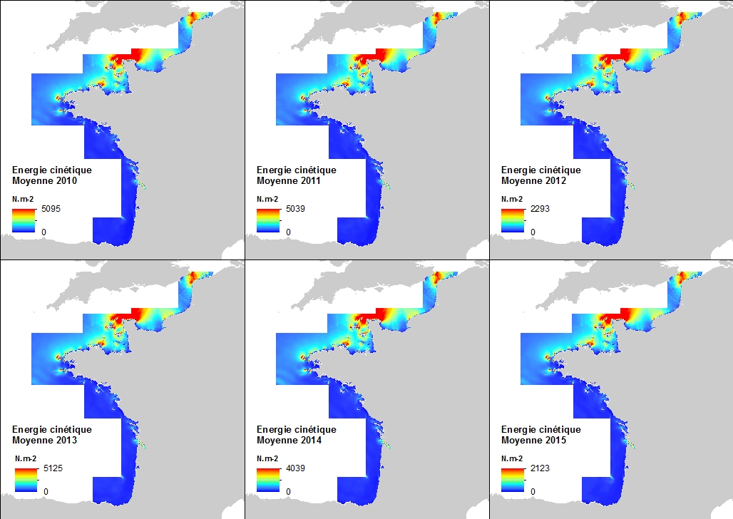
This annual statistics at 500m horizontal resolution was produced from the archived time series of MARS 3D physics model hindcast runs along French Atlantic Coast. The variable that is available here is the Kinetic Energy induced by currents caused by tide, water density gradients and action of winds. The formula used for the Kinetic Energy calculation is 0.5mv², where m is the density of seawater (1027 kg.m-3) and v is the current-induced velocity. Values are expressed in N.m-2 (Newton per square meter). In each pixel the value is an average of the values of the 40 vertical levels that are considered in the model.
-
Base de donnée hydrodynamique réalisée avec le modèle MARS3D et la librairie AGRIF (V10.10) le long de la façade atlantique française à la résolution spatiale de 500m et à la fréquence horaire. La mise en place de zooms avec la librairie AGRIF (http://www-ljk.imag.fr/MOISE/AGRIF/) le long de la façade atlantique a permis d’augmenter la résolution à 500m et localement à 100m (Golfe du Morbihan). Un rejeu sur cinq ans a été produit avec l’ensemble des zooms pour établir des climatologies en zone côtière à haute résolution.Une simulation de six années allant de 2010 à 2015 a été réalisée pour l’ensemble des emprises couvrant la façade atlantique.
-

This annual statistics at 500m horizontal resolution was produced from the archived time series of MARS 3D physics model hindcast runs along French Atlantic Coast. The variable that is available here is the Kinetic Energy induced by currents caused by tide, water density gradients and action of winds. The formula used for the Kinetic Energy calculation is 0.5mv², where m is the density of seawater (1027 kg.m-3) and v is the current-induced velocity. Values are expressed in N.m-2 (Newton per square meter). The vertical level is the sea surface.
 Catalogue PIGMA