 Catalogue PIGMA
IFREMER
Type of resources
Available actions
Topics
Keywords
Contact for the resource
Provided by
Years
Formats
Representation types
Update frequencies
status
Service types
Scale
Resolution
-
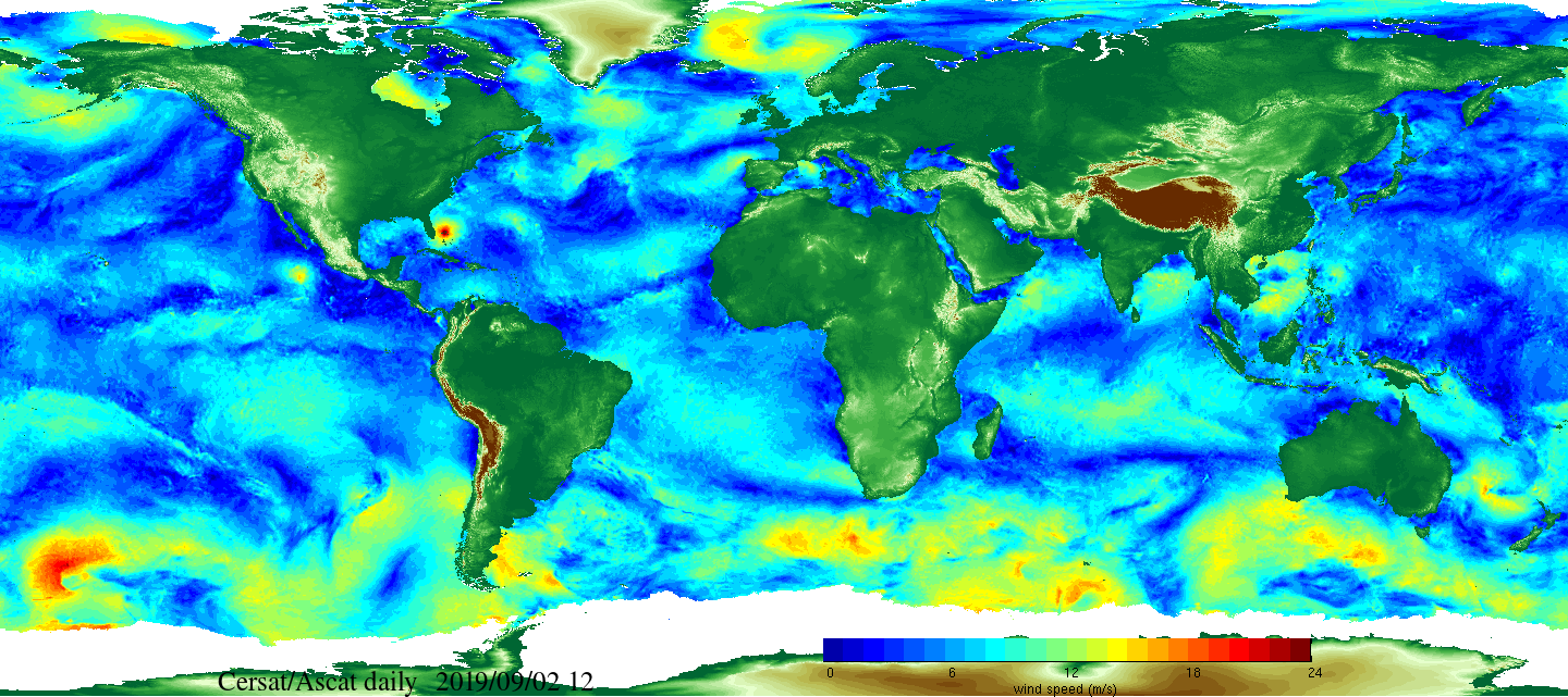
Daily and monthly surface wind analyses are determined as gridded wind products over global oceans, with regular spatial resolution of 0.25° in latitude and longitude. They are estimated from scatterometer wind retrievals (L2b data). According to the scatterometer sampling scheme, the objective method allowing the determination of regular in space surface wind fields uses remotely sensed observations as well as ECMWF analyses. The calculation of daily estimates uses ascending as well as descending available and valid retrievals. The objective method aims to provide daily-averaged gridded wind speed, zonal component, meridional component, wind stress and the corresponding components at global scale. The error associated to each parameter, related to the sampling impact and wind space and time variability, is provided too. Monthly wind analyses are calculated from daily estimates.
-
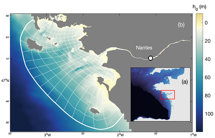
A ten-year numerical hindcast of hydrodynamics, hydrology and sediment dynamics in the Loire Estuary (France), produced by coupling the hydrodynamics model MARS3D with the sediment dynamics module MUSTANG and the wave spectral model WAVEWATCH III®. Numerical simulations are based on the same model chain used in the Seine Estuary (curviseine) and the Gironde Estuary (curvigironde).
-

Raw multibeam from acoustic echosounding of the water column and archived at SISMER. These data have been acquired: - by oceanographic vessels and national equipment managed by the French Oceanographic Fleet (FOF) - by foreign or national oceanographic vessels in collaboration with Ifremer
-

Analysis of tuna stomach contents
-
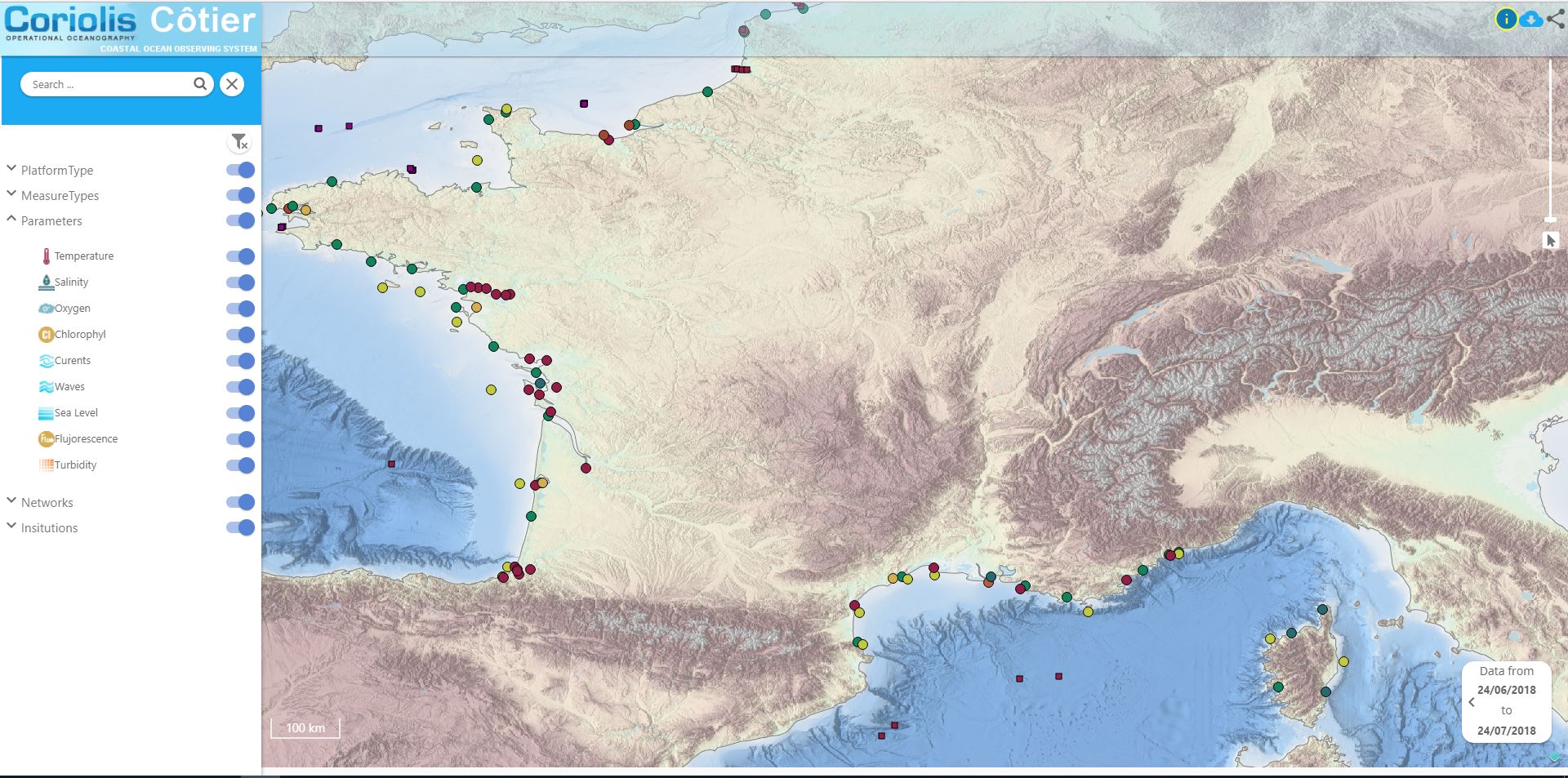
Data available in the French Coast
-
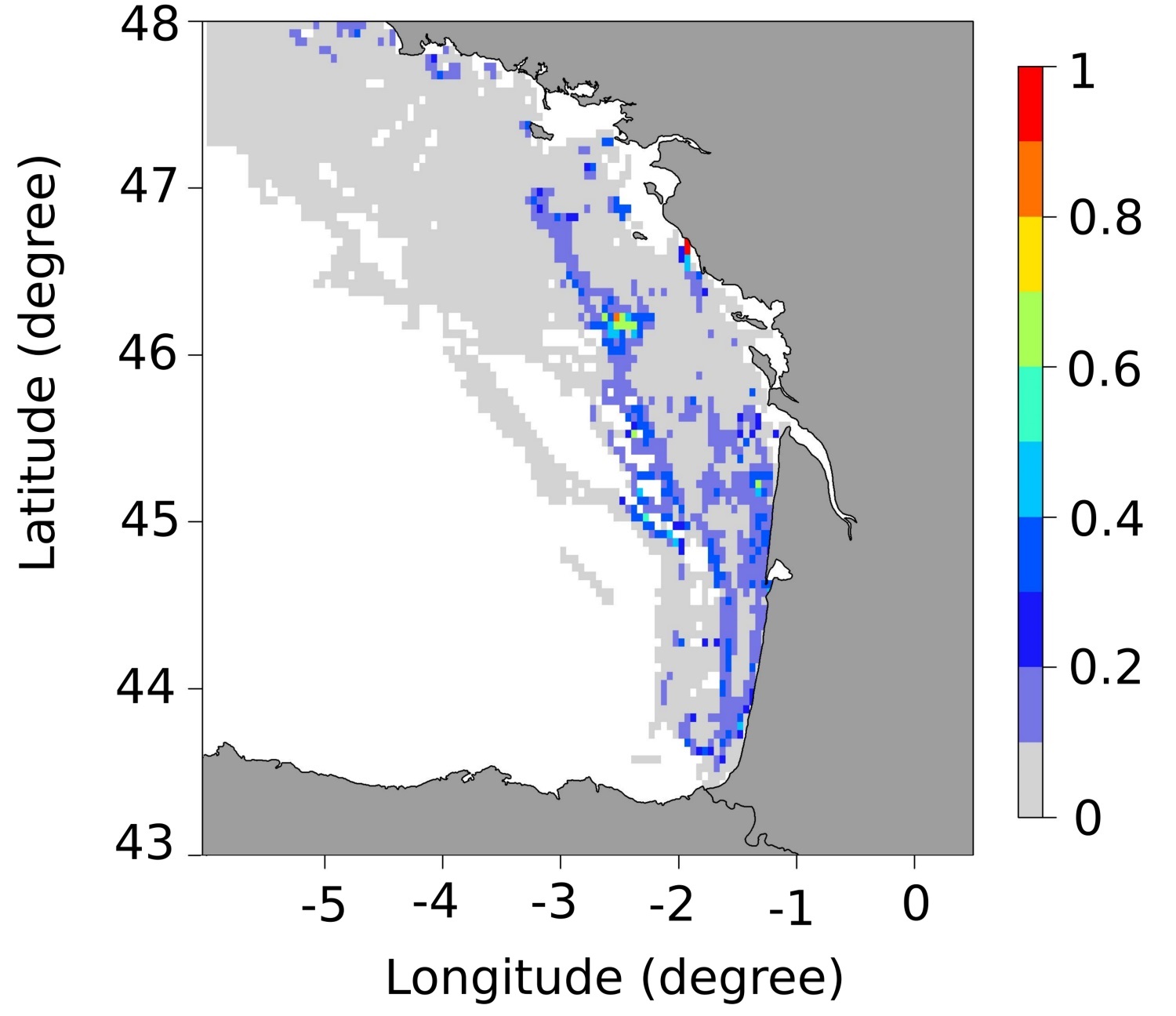
These maps represent the monthly probability of being a seabass spawning area for each month of the spawning season (January to March), and the mean probability of being a seabass spawning area over all spawning months in the Bay of Biscay. These probability maps were calculated by performing a geostatistical analysis of fishing data from geolocated vessels, and have a spatial resolution of 3 by 3 nautical miles.
-
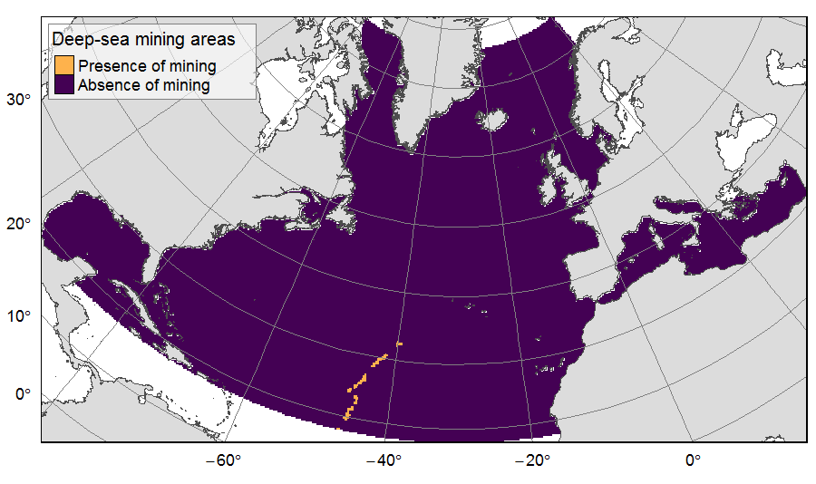
Presence of deep-sea mining exploration zones on the North Atlantic (18°N to 76°N and 36°E to 98°W). These areas correspond to the three polymetallic sulphides exploration contracts on the Mid-Atlantic Ridge, attributed to Poland, France and Russia. Each of the three contract areas is divided into 100 squares of 10km by 10km. Source polygons originated from the International Seabed Authority. The presence (value=1) of deep-sea mining was extracted in 25km * 25km gridsquares. This dataset was built to feed a basin-wide spatial conservation planning exercise, targeting the deep sea of the North Atlantic. The goal of this approach was to identify conservation priority areas for Vulnerable Marine Ecosystems (VMEs) and deep fish species, based on the distribution of species and habitats, human activities and current spatial management.
-

Distribution of three geomorphologic features (fracture zones, canyons, and seamounts) on the North Atlantic (18°N to 76°N and 36°E to 98°W). Source vector data originated from the GEBCO Gazetteer of Undersea Features Names for fractures, Harris & Whiteway (2011) for canyons, and Yesson et al. (2011) for seamounts. The presence (value=1) of fracture zones or seamounts and the total length of canyons (in km, independently for shelf-incising or blind canyons) was extracted in 25km * 25km gridsquares. This dataset was built to feed a basin-wide spatial conservation planning exercise, targeting the deep sea of the North Atlantic. The goal of this approach was to identify conservation priority areas for Vulnerable Marine Ecosystems (VMEs) and deep fish species, based on the distribution of species and habitats, human activities and current spatial management.
-
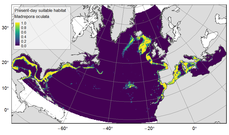
Distribution of predicted suitable habitat for six cold-water-coral, six deep-water fish and one sponge species, on the North Atlantic (18°N to 76°N and 36°E to 98°W). For each species, predicted habitat distribution was obtained for present-day conditions (1951-2000) and for the future climate refugias, i.e. the areas that were predicted as suitable both for present-day and forecasted future (2081-2010) conditions. The dataset gathers 26 raster layers created on the same grid of 25km * 25km resolution, downgraded from source layers (3km *3km resolution) that were created within the work package 3 of EU ATLAS project. The presence (value=1) of climate refugia and the relative cover (value ranging from 0 to 1) of present-day suitable habitat was extracted in gridsquares. This dataset was built to feed a basin-wide spatial conservation planning exercise, targeting the deep sea of the North Atlantic. The goal of this approach was to identify conservation priority areas for Vulnerable Marine Ecosystems (VMEs) and deep fish species, based on the distribution of species and habitats, human activities and current spatial management.
-
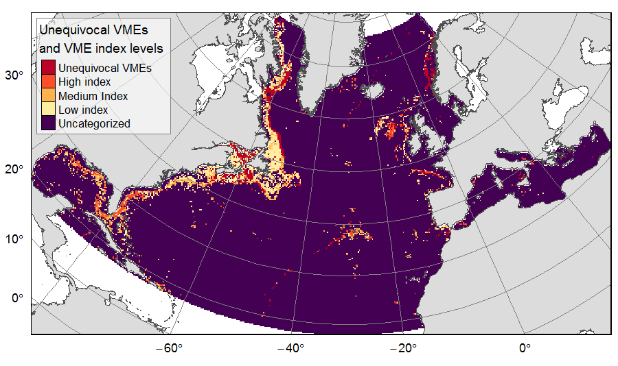
Distribution of unequivocal Vulnerable Marine Ecosystems (VMEs) and VME likelihood based on indicator taxa records, on the North Atlantic (18°N to 76°N and 36°E to 98°W). Several datasets, originating from public databases, literature review and data call to ATLAS partners, were gathered to compute the presence of unequivocal VME habitats in 25km * 25 km cells for the ATLAS work package 3. One layer displays the unequivocal VMEs (value=4) and the assigned high (value=3), medium (value=2) or low (value=1) likelihood of gridsquares to host VMEs, indexed on indicator taxa records from public databases with the method detailed in Morato et al (2018). The second displays the confidence associated to the VME likelihood score, indexed on data quality as detailed in Morato et al (2018) (values for unequivocal VMEs thus 100% confidence=4; high confidence=3; medium confidence=2; low confidence=1). This dataset was built to feed a basin-wide spatial conservation planning exercise, targeting the deep sea of the North Atlantic. The goal of this approach was to identify conservation priority areas for Vulnerable Marine Ecosystems (VMEs) and deep fish species, based on the distribution of species and habitats, human activities and current spatial management.