 Catalogue PIGMA
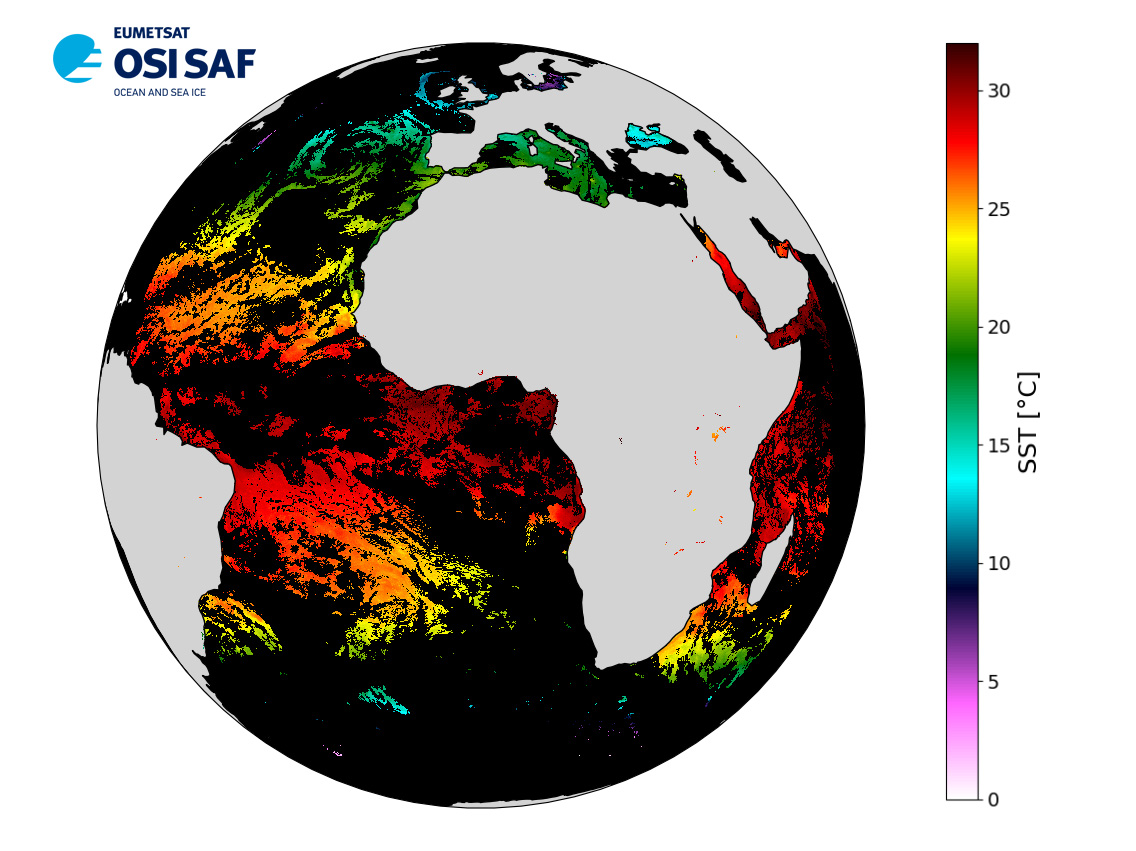
EUMETSAT OSI SAF Meteosat 0° Sea Surface Temperature
Level 3 hourly sub-skin Sea Surface Temperature derived from Meteosat at 0° longitude, covering 60S-60N and 60W-60E and re-projected on a 0.05° regular grid, in GHRSST compliant netCDF format.
The satellite input data has successively come from Meteosat level 1 data processed at EUMETSAT. SST is retrieved from SEVIRI using a multi-spectral algorithm and a cloud mask.
Atmospheric profiles of water vapor and temperature from a numerical weather prediction model, Sea Surface Temperature from an analysis, together with a radiative transfer model, are used to correct the multispectral algorithm for regional and seasonal biases due to changing atmospheric conditions.The quality of the products is monitored regularly by daily comparison of the satellite estimates against buoy measurements.
The product format is compliant with the GHRSST Data Specification (GDS) version 2. Users are advised to use data only with quality levels 3, 4 and 5.
Simple
- Date (Creation)
- 2004-06-01T22:13:37.040Z
- Date (Revision)
- 2004-06-01T05:01:46.000Z
- Date (Publication)
- 2004-06-01
- Edition
- 1
- Edition date
- 2015-05-29T00:00:00.000Z
- Identifier
- gov.nasa.esdis.umm.shortname / SEVIRI_SST-OSISAF-L3C-v1.0
- Codespace
- gov.nasa.esdis.umm.collectiondatatype
- Name
- SEVIRI Atlantic SST
- Other citation details
- EUMETSAT/OSI SAF, EUMETSAT Ocean and Sea Ice Satellite Application Facility, Meteo-France/CMS, Lannion, France, 2015-05-29, GHRSST Level 3C Atlantic sub-skin Sea Surface Temperature from the Spinning Enhanced Visible and Infrared Imager (SEVIRI) on MSG at 0 degree longitude (GDS V2) produced by OSI SAF, www.osi-saf.org
- Status
- onGoing On going
- GEMET - INSPIRE themes, version 1.0
-
- Oceanographic geographical features
- Cersat - Parameter
-
- Ocean Temperature
- Cersat - Project
-
- GHRSST
- OSI SAF
- Cersat - GCMD parameter
-
- /Ocean Temperature/Sea Surface Temperature
- Centre de données ODATIS
-
- CDS-CERSAT
- Type de jeux de donnée ODATIS
-
- /Observational data/satellite
- Access constraints
- unrestricted
- Other constraints
- Open Licence
- Distance
- 0.05 degree
- Metadata language
- English
))
- Geographic identifier
- Global
- Begin date
- 2004-06-01
- Reference system identifier
- CARTESIAN
- Reference system identifier
- http://www.opengis.net/def/crs/EPSG/0/4326
- Number of dimensions
- 2
Axis Dimensions Properties
Axis Dimensions Properties
- Distribution format
-
-
NetCDF
(
4
)
-
NetCDF
(
4
)
Distributor
- Name
- Format: Not provided MimeType: text/html
Distributor
- Name
- Format: Not provided MimeType: text/html
- OnLine resource
- Digital Object Identifier (DOI) ( DOI )
- OnLine resource
- OSI SAF Opensearch service ( WWW:LINK )
- OnLine resource
- NASA PO.DAAC ( WWW:LINK )
- OnLine resource
- Ifremer HTTP server ( WWW:LINK )
- OnLine resource
-
Ifremer FTP server
(
WWW:FTP
)
FTP
- OnLine resource
- EUMETCast ( WWW:BROADCAST )
- OnLine resource
-
Local path on Datarmor (Ifremer restricted) platform
(
NETWORK:LINK
)
Local path
- OnLine resource
-
User guide
(
WWW:LINK
)
Product User Manual
- Hierarchy level
- Series
Accuracy of time measurement
- Measure identification
- PrecisionOfSeconds
Quantitative result
Content Information
- Attribute description
- Global gridded map
- Content type
- Physical measurement
- gmd:otherProperty
- earliest_granule_start_time Earliest Granule Start Time for dataset. 2004-06-01T00:00:00.000Z latest_granule_end_time Latest Granule Stop/End Time for dataset. 2021-05-21T13:26:57.000Z data_latency Dataset Latency 24 Series Name Dataset citation series name SEVIRI Atlantic SST Persistent ID Dataset Persistent ID PODAAC-GHSEV-3CO01
- Processing level code
- L3C /
Content Information
- File identifier
- e38c8087-a147-4522-aca7-a3e7f28376c0 XML
- Metadata language
- English
- Character set
- UTF8
- Hierarchy level
- Series
- Date stamp
- 2024-10-15T14:57:07.277662Z
- Metadata standard name
- ISO 19115-3:2018 - Remote Sensing
Overviews
Spatial extent
Provided by
