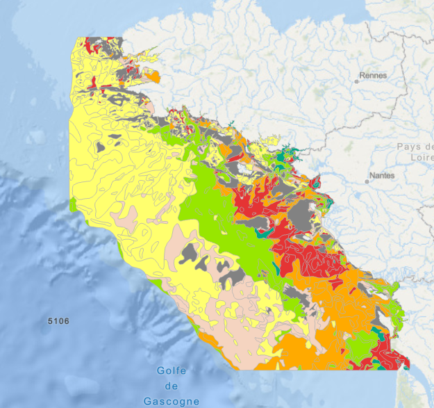
Map of surficial sediments of the northern continental shelf of the Bay of Biscay (P. Bouysse, A. Klingebiel, P. Lesueur, 1986)
Map of surficial sediments of the northern continental shelf of the Bay of Biscay at 1:500000 by Philippe BOUYSSE, Patrick LESUEUR, André KLINGEBIEL et al., 1986, conducted jointly by the BRGM and Ifremer.
Simple
- Date (Creation)
- 1986-01-01T00:00:00
- Date (Publication)
- 1986-01-01T00:00:00
- Identifier
- FR-330-715-368-00032-FaciesSedimentaires_GolfedeGascogne_Bouysse_1986
- Presentation form
- Digital map
- Credit
- BRGM / Ifremer
- Status
- Completed
- Maintenance and update frequency
- As needed
- Thèmes Sextant
-
- /Physical Environment/Geology
- external.theme.gemet
-
- seabed
- marine sediment
- Theme
-
- sedimentology
- Place
-
- Atlantic
- Bay of Biscay
- France
- Discipline
-
- geophysics
- GEMET - INSPIRE themes, version 1.0
-
- Geology
- Sous-regions marines
-
- /Metropolitan France/Celtic Seas
- /Metropolitan France/Bay of Biscay
- Access constraints
- Other restrictions
- Use constraints
- Copyright
- Other constraints
- Références bibliographiques à citer : BOUYSSE P., LESUEUR P. et KLINGEBIEL A., 1986. Carte des sédiments superficiels du plateau continental du Golfe de Gascogne - Partie septentrionale. Echelle 1/500 000. coédition BRGM / Ifremer.
- Spatial representation type
- Vector
- Denominator
- 500000
- Metadata language
- Français
- Character set
- UTF8
- Topic category
-
- Geoscientific information
N
S
E
W
))
- Reference system identifier
- EPSG / WGS 84 (EPSG:4326) / 7.4
- Topology level
- Geometry only
- Geometric object type
- Surface
- Geometric object count
- 1038
- OnLine resource
-
FaciesSedimentaires_GolfedeGascogne_Bouysse_1986
(
OGC:WMS
)
sedimentary facies
- Protocol
- FILE
- Name
- FaciesSedimentaires_GolfedeGascogne_Bouysse_1986
- Description
- sedimentary facies
- Hierarchy level
- Dataset
Conformance result
- Date (Publication)
- 2007-03-14
- Explanation
- not evaluated
- Pass
- No
- Statement
- The data comes from the scanned the map of Bouysse P. (coord.), Lesueur P. and Klingebiel A., 1986. Map of surficial sediments of the Bay of Biscay continental shelf – northernmost part at 1:500,000. co-edited by BRGM & IFREMER.
- Description
- Mercator projection, reference latitude 46N, central meridian 0, WGS_84 ellipsoid
- File identifier
- ea0b61b0-71c6-11dc-b1e4-000086f6a62e XML
- Metadata language
- Français
- Character set
- UTF8
- Hierarchy level
- Dataset
- Date stamp
- 2024-10-07T15:01:10.125903Z
- Metadata standard name
- ISO 19115:2003/19139 - SEXTANT
- Metadata standard version
- 1.0
Overviews

Spatial extent
N
S
E
W
))
Provided by

Associated resources
Not available
 Catalogue PIGMA