 Catalogue PIGMA
250000
Type of resources
Available actions
Topics
Keywords
Contact for the resource
Provided by
Years
Formats
Representation types
Update frequencies
status
Scale
Resolution
-
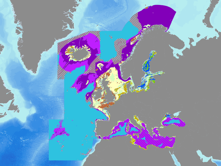
Confidence in the full output of the 2016 EUSeaMap broad-scale predictive model, produced by EMODnet Seabed Habitats. Values are on a range from 1 (low confidence) to 3 (high confidence). Confidence is calculated by amalgamating the confidence values of the underlying applicable habitat descriptors used to generate the habitat value in the area in question. Habitat descriptors differ per region but include: Biological zone Energy class Oxygen regime Salinity regime Seabed Substrate Riverine input Confidence in habitat descriptors are driven by the confidence in the source data used to determine the descriptor, and the confidence in the threshold/margin (areas closer to a boundary between two classes will have lower confidence). Confidence values are also available for each habitat descriptor and input data layer.
-
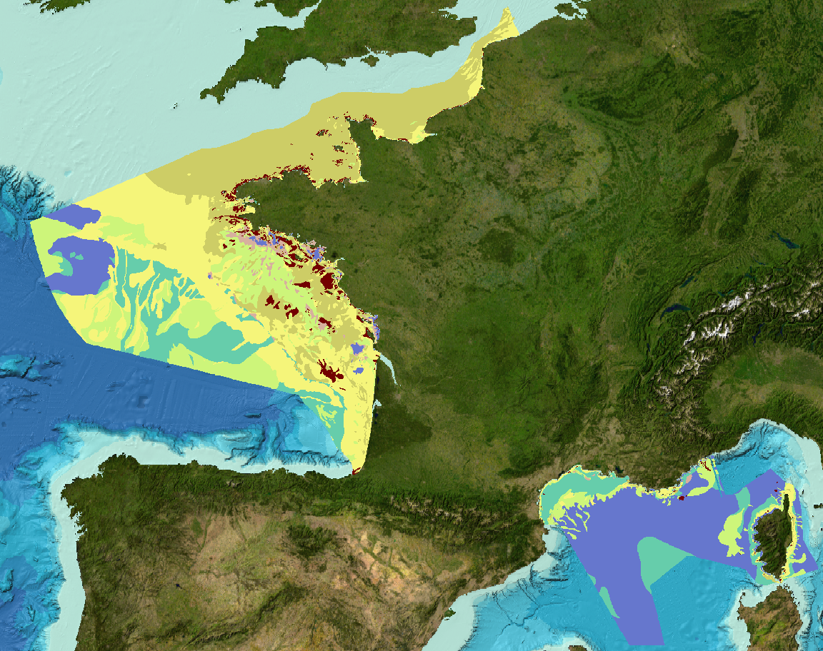
Sediment substrate maps at different scales, of the French metropolitan EEZ produced in the work-package 3 the European project EMODNet Geology (phase IV). Available scales : - 1 : 1 000 000 - 1 : 250 000 - 1 : 100 000 - 1 : 50 000 - 1 : 20 000 - 1 : 15 000 - 1 : 10 000 - 1 : 5 000 Bibliographic references : - Coltman, N., Gilliland, P. & van Heteren, S. 2007. What can I do with my map? In: MESH Guide to Habitat Mapping, MESH Project, 2007, JNCC, Peterborough. Available online at: (http://www.searchmesh.net/default.aspx?page=1900) - Foster-Smith, R., Connor, D. & Davies, J. 2007. What is habitat mapping? In: MESH Guide to Habitat Mapping, MESH Project, 2007, JNCC, Peterborough. Available online at: (http://www.searchmesh.net/default.aspx?page=1900) - Väänänen, T. (ed), Hyvönen, E., Jakonen, M., Kupila, J., Lerrsi, J., Leskinen, J., Liwata, P., Nevalainen, R., Putkinen, S., Virkki, H. 2007. Maaperän yleiskartan tulkinta- ja kartoitusprosessi. Maaperän yleiskartoitus –hankkeen sisäinen raportti. 17 p.
-

Map of the sedimentation rates within the French metropolitan EEZ produced in the work-package 3 (seabed substrate) of the European project EMODnet Geology. This version of the dataset corresponds to the phase III of the project.
-
EUSeaMap 2021 is the fifth iteration of EUSeaMap. All versions have been produced as part of the EMODnet Seabed Habitats project, which is one of several thematic lots in EMODnet. The project has brought together a European consortium of specialists in benthic ecology and seabed habitat mapping. The partners first collaborated in EMODnet phase 1 (2009-2012) to deliver a prototype predictive seabed habitat map in four trial basins (Greater North Sea, Celtic Seas, Baltic, Western Mediterranean). This predictive model was named EUSeaMap (Cameron and Askew, 2011). In EMODnet Phase 2 (2012-2016), the consortium extended EUSeaMap coverage to all European regions (Populus et al, 2017). In phase 3 (2017-2021), a first version (2019) extended the spatial coverage further North in order to include the Barents Sea, developed better environmental data were incorporated, and dramatically improved the spatial detail. The new version, developed in the period 2019-2021 and named 2021, is substantially evolved from the previous version as it accounts for new seabed substrate data published by EMODnet Geology in 2021, including in Denmark, Estonia, France, Ireland, Italy, Latvia, Norway and Spain, 2) is published in new classifications, including the new version of the marine section of EUNIS, named EUNIS 2019 and 3) addresses some issues identified in EUSeaMap 2019.
-
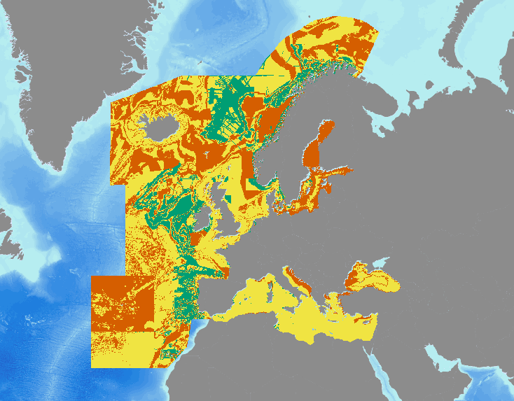
Output of the 2016 EUSeaMap broad-scale predictive model, produced by EMODnet Seabed Habitats and aggregated into the predominant habitats of the Marine Strategy Framework Directive. The extent of the mapped area includes the Mediterranean Sea, Black Sea, Baltic Sea, and areas of the North Eastern Atlantic extending from the Canary Islands in the south to Norway in the North. The map was produced using a "top-down" modelling approach using classified habitat descriptors to determine a final output habitat. Habitat descriptors differ per region but include: Biological zone Energy class Oxygen regime Salinity regime Seabed Substrate Riverine input Habitat descriptors (excepting Substrate) are calculated using underlying physical data and thresholds derived from statistical analyses or expert judgement on known conditions. The model is produced in Arc Model Builder (10.1). For more information on the modelling process please read the EMODnet Seabed Habitats The model was created using raster input layers with a cell size of 0.002dd (roughly 250 meters). The model includes the sublittoral zone only; due to the high variability of the littoral zone, a lack of detailed substrate data and the resolution of the model, it is difficult to predict littoral habitats at this scale.
-
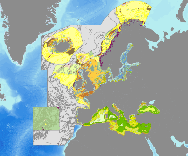
Output of the 2016 EUSeaMap broad-scale predictive model, produced by EMODnet Seabed Habitats. The extent of the mapped area includes the Mediterranean Sea, Black Sea, Baltic Sea, and areas of the North Eastern Atlantic extending from the Canary Islands in the south to Norway in the North. The map was produced using a "top-down" modelling approach using classified habitat descriptors to determine a final output habitat. Habitat descriptors differ per region but include: Biological zone Energy class Oxygen regime Salinity regime Seabed Substrate Riverine input Habitat descriptors (excepting Substrate) are calculated using underlying physical data and thresholds derived from statistical analyses or expert judgement on known conditions. The model is produced in Arc Model Builder (10.1). For more information on the modelling process please read the EMODnet Seabed Habitats The model was created using raster input layers with a cell size of 0.002dd (roughly 250 meters). The model includes the sublittoral zone only; due to the high variability of the littoral zone, a lack of detailed substrate data and the resolution of the model, it is difficult to predict littoral habitats at this scale. The map follows the EUNIS 2007-11 classification system where it is appropriate.
-
Landslides and gravitational features mapped within French metropolitan EEZ at 1 : 250 000 in the framework of work-package 6 (Geological Events and Probabilities) of the european project EMODNet Geology. These datasets were delivered during the phase 2 of the project.
-
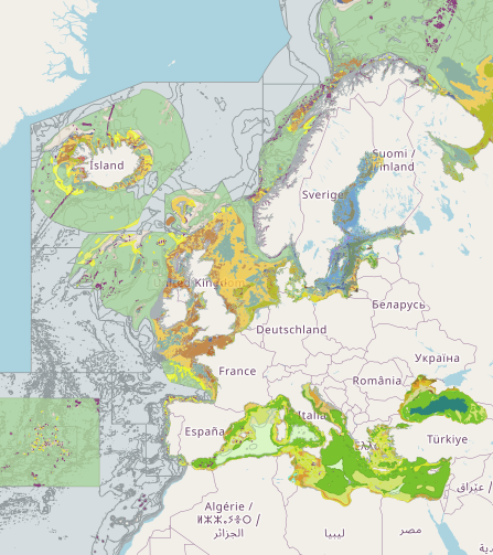
Output of the 2019 EUSeaMap broad-scale predictive model, produced by EMODnet Seabed Habitats. The extent of the mapped area includes the Mediterranean Sea, Black Sea, Baltic Sea, and areas of the North Eastern Atlantic extending from the Canary Islands in the south to the Barents Sea in the north. The map was produced using a "top-down" modelling approach using classified habitat descriptors to determine a final output habitat. Habitat descriptors differ per region but include: Biological zone Energy class Oxygen regime Salinity regime Seabed substrate Riverine input Habitat descriptors (excepting Substrate) are calculated using underlying physical data and thresholds derived from statistical analyses or expert judgement on known conditions. The model is produced using R and Arc Model Builder (10.1). The model was created using raster input layers with a cell size of 0.00104dd (roughly 100 metres). The model includes the sublittoral zone only; due to the high variability of the littoral zone, a lack of detailed substrate data and the resolution of the model, it is difficult to predict littoral habitats at this scale. This map follows the EUNIS 2007-11 classification system where it is appropriate. It has also been classified according to MSFD Benthic Broad Habitat types. This report details the methods used in the previous version (v2016) - a new report is in progress: Populus J. And Vasquez M. (Eds), 2017. EUSeaMap, a European broad-scale seabed habitat map. Ifremer Available from: http://archimer.ifremer.fr/doc/00388/49975/
-
Aggregates map at 1 : 250 000 of the French metropolitan EEZ produced in the work-package 7 (marine minerals) of the European project EMODnet Geology. This version of the dataset corresponds to the phase IV of the project.
-