/Human activities/Fisheries
Type of resources
Available actions
Topics
Keywords
Contact for the resource
Provided by
Years
Formats
Representation types
Update frequencies
status
Resolution
-

The primary aim of the Fisheries and Resources Monitoring System (FIRMS) is to provide access to a wide range of high-quality information on the global monitoring and management of fishery marine resources. FIRMS draws together a unified partnership of international organizations, regional fishery bodies and, in the future, national scientific institutes, collaborating within formal agreement to report and share information on fisheries resources. For effective fisheries information management, FIRMS also participates in the development and promotion of agreed standards. FIRMS system is part of the Fisheries Global Information System (FIGIS). Information provided by the partners is organized in a database and published in the form of fact sheets. This system provides the data owner with tools to ensure controlled dissemination of high quality and updated information.
-

The GRSF, the Global Record of Stocks and Fisheries, integrates data from three authoritative sources: FIRMS (Fisheries and Resources Monitoring System), RAM (RAM Legacy Stock Assessment Database) and FishSource (Program of the Sustainable Fisheries Partnership). The GRSF content disseminated through this catalogue is distributed to test the logic to generate unique identifiers and review collated stock and fishery data. This beta release can contain errors and we welcome feedback on content and software performance, as well as the overall usability. Beta users are advised to use caution and to not rely in any way on the application and/or trust content and accompanying materials. What is the GRSF? A comprehensive and transparent inventory of stocks and fisheries records across multiple data providers.
-

This is the FAO Fishery and Aquaculture Reference Data repository: Codes and reference data for fishing gear, species, currencies, commodities, countries and others.
-

The Commission for the Conservation Southern Bluefin Tuna collects a variety of data types from its Members and Cooperating Non-Members, including total catch, catch and effort data, and catch at size data. Catch, size and trade information is also collected through the Commission's Catch Documentation Scheme, Japanese import statistics, and other monitoring programs. Annual catches provided on this page are reported on a calendar year basis. CCSBT Members use quota years (not calendar years) for managing catching limits, but quota years differ between Members, so calendar years are used to provide catches on a common timescale. Relevant subsets and summaries of these data are provided below. All figures are subject to change as improved data or estimates become available. In particular, reviews of SBT data in 2006 indicated that southern bluefin tuna catches may have been substantially under-reported over the previous 10-20 years and the data presented here do not include estimates for this unreported catch. Also, data for the last reported year of catch (2020) are preliminary and are subject to revision. Any latitudes and longitudes presented in these summaries represent the north western corner of the relevant grid, which is a 5*5 grid unless otherwise specified. Other information on Members and Cooperating Non-Members fishing activities appears in the reports of the Extended Scientific Committee, Compliance Committee and Extended Commission.
-

OSPAR is the mechanism by which 15 Governments & the EU cooperate to protect the marine environment of the North-East Atlantic. OSPAR started in 1972 with the Oslo Convention against dumping and was broadened to cover land-based sources of marine pollution and the offshore industry by the Paris Convention of 1974. These two conventions were unified, up-dated and extended by the 1992 OSPAR Convention. The new annex on biodiversity and ecosystems was adopted in 1998 to cover non-polluting human activities that can adversely affect the sea. The fifteen Governments are Belgium, Denmark, Finland, France, Germany, Iceland, Ireland, Luxembourg, The Netherlands, Norway, Portugal, Spain, Sweden, Switzerland and United Kingdom. OSPAR is so named because of the original Oslo and Paris Conventions ("OS" for Oslo and "PAR" for Paris). OSPAR Data & Information Management System (ODIMS) is a fully featured platform for accessing OSPAR's geospatial maps, data and metadata. 61 Maps and 254 layers regarding: - Cables and pipelines - Comprehensive atmospheric monitoring programme - Discharges of radionuclides from the non-nuclear sectors - Discharges, spills and emissions from offshore oil and gas installations - Dumping and placement of wastes or other matter at sea - Environmental monitoring of radioactive substances - Fishing for litter - Vulnerable marine ecosystems - etc.
-
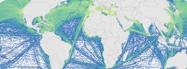
This is a portion of the data used to calculate 2008 and 2013 cumulative human impacts in: Halpern et al. 2015. Spatial and temporal changes in cumulative human impacts on the world's ocean. Seven data packages are available for this project: (1) supplementary data (habitat data and other files); (2) raw stressor data (2008 and 2013); (3) stressor data rescaled by one time period (2008 and 2013, scaled from 0-1); (4) stressor data rescaled by two time periods (2008 and 2013, scaled from 0-1); (5) pressure and cumulative impacts data (2013, all pressures); (6) pressure and cumulative impacts data (2008 and 2013, subset of pressures updated for both time periods); (7) change in pressures and cumulative impact (2008 to 2013). All raster files are .tif format and coordinate reference system is mollweide wgs84. Here is an overview of the calculations: Raw stressor data -> rescaled stressor data (values between 0-1) -> pressure data (stressor data after adjusting for habitat/pressure vulnerability) -> cumulative impact (sum of pressure data) -> difference between 2008 and 2013 pressure and cumulative impact data. This data package includes 2008 and 2013 raw stressor data. The 2008 data includes 18 raster files (preceeded by raw_2008_). The 2013 data includes 19 raster files (preceeded by raw_2013_). There is no sea level rise data for 2008.
-

Maps of potential biomass catches (tons/year) per surface unit (0.25º latitude x 0.25º longitude) based on 3-D probability of occurrence for the main commercial fish species of the Atlantic. To map potential catches, first, mean catches (tons/year) were calculated according to Watson (2020) Global fisheries landings (V4) database for period 2010-2015 and then the total mean catch value for each species was redistributed according to the occurrence probability value that was modelled in 3-D using Shape-Constrained Generalized Additive Models (SC-GAMs). Potential catch value of each cell integrates the catches along the water column (from surface until 1000 m depth). See Valle et al. (2024) in Ecological Modelling 490:110632 ( https://doi.org/10.1016/j.ecolmodel.2024.110632 ), for more details.
-

ICES hosts data collected from both net trawl surveys (primarily bottom trawling), and from echo sounding (acoustic sampling in the pelagic zone). The net trawls are primarily hosted in the DATRAS data portal, and the acoustics in the acoustic trawl surveys portal. DATRAS (the Database of Trawl Surveys) stores data collected primarily from bottom trawl fish surveys coordinated by ICES expert groups. The survey data are covering the Baltic Sea, Skagerrak, Kattegat, North Sea, English Channel, Celtic Sea, Irish Sea, Bay of Biscay and the eastern Atlantic from the Shetlands to Gibraltar. At present, there are more than 45 years of continuous time series data in DATRAS, and survey data are continuously updated by national institutions. The acoustic database hosts information on fisheries observations collected from various pelagic surveys coordinated by ICES and falls into two categories: acoustic data, derived from readings taken on vessels, and those obtained through trawls in the open ocean – pelagic – zone. Combined, this provides key biological data on fish stocks such as herring, mackerel and blue whiting as well as krill and other prey species. The data from both systems are used for stock assessments and fish community studies by the ICES community and form the basis of management advice to the relevant regulatory bodies.
-
The observation of sales consists of periodically measuring the size of individuals of the main species at auctions and landing points, taking into account the commercial names used at the point of sale. This system, called ObsVentes, is applied in metropolitan France and in the French overseas territories : Guyane, Guadeloupe, Martinique, Réunion and Mayotte.
-

The observation of catches at sea, whether landed or discarded by professional fishing vessels, provides a better understanding of the interactions between fishing activity, resources and marine ecosystems. This system, called ObsMer, is applied in metropolitan France, excluding Corsica.
 Catalogue PIGMA