 Catalogue PIGMA
Biotoxins
Type of resources
Available actions
Topics
Keywords
Contact for the resource
Provided by
Years
Formats
Representation types
Update frequencies
status
Scale
-

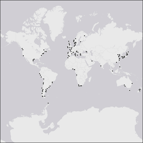
REPHYTOX dataset includes long-term time series on phycotoxins in marine bivalve molluscs, since 1987, along the whole French coast. The dataset covers results on lipophilic toxins, PSP toxins, ASP toxins, and palytoxins. REPHYTOX was a full part of the REPHY network until 2015. The whole dataset is available.
-
The table represents the global and regional distribution of DST measurements in marine animals, in Dinophysis cells from field sampling and in culture, as well as in the seawater (using solid phase adsorption toxin tracking, SPATT). The data encompass the locations, species and toxin profiles of Dinophysis spp. or taxa when marine animals were analyzed. Data were obtained and updated from Lee et al. (1989), Blanco et al. (2005), Reguera and Pizarro (2008), Reguera et al. (2012a) and Reguera et al. (2014). Scientific publications on Dinophysis occurrences but without associated toxin profiles or quantifications were not included. Toxin content of Dinophysis spp. were reported in a per cell basis (pg cell-1) or in few cases in per volume (ng mL-1), when the concentration in a per cell basis was not available in the publications, while in marine animals, presence or absence of the toxins were shown. Marine animals are grouped by taxa (e.g. C. gigas and C. virginica = oysters). This work represents 461 records (from 1978 to July 2020) from 163 scientific publications, conference papers, reports and conference abstracts.
-
The definitive coastal information system, Quadrige stores coastal observation and monitoring network data. In order to manage coastal monitoring data, Ifremer developed the Quadrige² information system. Quadrige is one element of the Water Information System (SIE) http:// www.eaufrance.fr, et à ce titre, contribue aux travaux du Secrétariat d'Administration National des Données Relatives à l'Eau (SANDRE) http://www.sandre.eaufrance.fr. Quadrige Marine Zones is a reference source unique to the Quadrige system. It is used to break down the coast of the French mainland and overseas territories into large areas and to connect each one with observation and monitoring locations.